All Activity
- Past hour
-
That's cheating!
-
Second round weakened as it came thru which is fine. It must be wild near Wheaton to west of Columbia because radar looks stronger than it was here and it was HEAVY
-
Absolute sheet of downpouring whiteness
-
104 in NYC on Tuesday lol
-
Aha! 12z EURO has southerly winds on the coast for Monday, most of NYC has dropped into the 80s and some 70s by 8PM. But Tuesday might still look hot, I don't have it yet but winds go westerly overnight/very early Tuessday morning.
-
4 complete days no sun here
-
New England into the Mid-Atlantic/Southeast... Strong heating is expected across a broad, moist warm sector with dewpoints in the upper 60s to low 70s east of the Appalachians by Thursday afternoon. This will result in moderate to potentially strong instability across much of the East Coast. The best chance for more organized storms will be from central Virginia northward where stronger shear will be present beneath 50 knot mid-level flow. A zone of potentially greater severe weather probabilities may be present across the Mid-Atlantic where the greatest instability/shear are expected to overlap. It appears the cold front will lag well behind with the majority of convection developing along a pre-frontal trough during the afternoon. Without the stronger frontal forcing, some concerns about convective coverage/intensity exist, precluding higher probabilities at this time.
-
I seen that had to call a couple coworkers and tell them to get inside. (They never look at the weather really)
-

E PA/NJ/DE Summer 2025 Obs/Discussion
JTA66 replied to Hurricane Agnes's topic in Philadelphia Region
Trash night. I expect nothing less than flying cows 84F/DP 75F...a bit sticky -
Yes, the higher-end severe threat is definitely tomorrow.
-
PWS has already picked up 101 lightning strikes and counting. Sub-severe here but POURING and tons of thunder. Messy looking radar as well. Appetizer for tomorrow?
-
Decent thunderstorm 0.42” in 15min.
-
I’m going with 90 kts at the interim advisory
-
We’ve had some nasty stretches, but I never saw this week as crap. I’d argue yesterday was better here than today lol.
-
It has been muggy! My standing joke is: if you want a sweater for Christmas, I'm your guy! 5.35 inches of rain this month in Pleasant Gardens. 26.57 for the year.
-
Tomer Burg has been all over the EPS & Euro being too hot in the extended, see below tweet:
-
Landscaping now with Gatorade in hand. Today if you are outside working you needs extra hydration and electrolytes.
-
Likely some certainly helping but I think they've also been along an instability gradient and there have been subtle vorts moving through
-
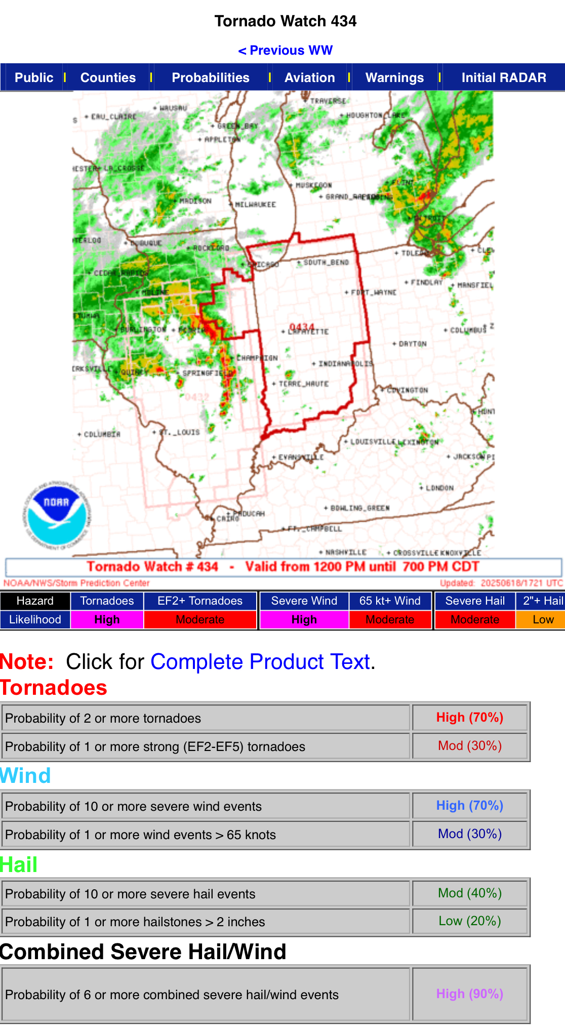
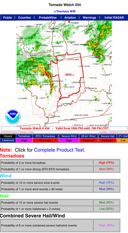
Nice probs on the new Tornado Watch.
-
The VIL on that severe warned storm is big time
-
Sunny as can be and muggy here Got the feeling
-
Not a drop here yet loud thunder
-
This will likely be another case of a strengthening hurricane til landfall. A Cat 4 at LF wouldn't surprise me.
-
Tornado possible near Detroit
-
Yeah, all that ...and, I'm personally suspect that these global model '2-meter temp' depictions are not in fact the actual 2-meter temperatures, but are really just stopping the adiabats at 1000 mb level and taking whatever it calculates at that sigma level. Pretty sure they lack the resolution in that lowest 20 someodd mb of the floor ... where the 2-meter slope temperature really is. It can be 95 at the top of downtown church steeples and 101 on the sidewalk going by.... Although, in the winter, they do better ... but then in the winter the sounding is pretty uniform ( typically..) in the lower 100mb