All Activity
- Past hour
-

December 2025 regional war/obs/disco thread
WinterWolf replied to Torch Tiger's topic in New England
Hilarious how 6z and 18z change all the time from 0z and 12z. -
December 2025 regional war/obs/disco thread
WinterWolf replied to Torch Tiger's topic in New England
Kevin in convince himself mode lol Coating to 2” at most currently. But we’ll take it. -
Not surprising at all. It’s been such a cold start to the month, knew we’d snap back the other way. With that said, GFS always shows extreme swings in long range. Probably more like upper [emoji[emoji[emoji638][emoji639][emoji[emoji6[emoji640][emoji638]][emoji640][emoji6[emoji640][emoji637]]][emoji[emoji638][emoji639][emoji[emoji6[emoji640][emoji638]][emoji640][emoji640]][emoji[emoji6[emoji640][emoji638]][emoji640][emoji640]]]][emoji[emoji[emoji638][emoji639][emoji[emoji6[emoji640][emoji638]][emoji640][emoji6[emoji640][emoji637]]][emoji[emoji638][emoji639][emoji[emoji6[emoji640][emoji638]][emoji640][emoji640]][emoji[emoji6[emoji640][emoji638]][emoji640][emoji640]]]][emoji639][emoji[emoji6[emoji640][emoji638]][emoji640][emoji6[emoji640][emoji637]]][emoji[emoji638][emoji639][emoji[emoji6[emoji640][emoji638]][emoji640][emoji640]][emoji[emoji6[emoji640][emoji638]][emoji640][emoji6[emoji640][emoji637]]]]][emoji[emoji6[emoji640][emoji638]][emoji640][emoji6[emoji640][emoji637]]][emoji[emoji[emoji638][emoji639][emoji[emoji6[emoji640][emoji638]][emoji640][emoji6[emoji640][emoji637]]][emoji[emoji638][emoji639][emoji[emoji6[emoji640][emoji638]][emoji640][emoji640]][emoji[emoji6[emoji640][emoji638]][emoji640][emoji640]]]][emoji[emoji[emoji638][emoji639][emoji[emoji6[emoji640][emoji638]][emoji640][emoji6[emoji640][emoji637]]][emoji[emoji638][emoji639][emoji[emoji6[emoji640][emoji638]][emoji640][emoji640]][emoji[emoji6[emoji640][emoji638]][emoji640][emoji640]]]][emoji639][emoji[emoji6[emoji640][emoji638]][emoji640][emoji6[emoji640][emoji637]]][emoji[emoji638][emoji639][emoji[emoji6[emoji640][emoji638]][emoji640][emoji640]][emoji[emoji6[emoji640][emoji638]][emoji640][emoji6[emoji640][emoji637]]]]][emoji[emoji6[emoji640][emoji638]][emoji640][emoji6[emoji640][emoji637]]][emoji[emoji638][emoji639][emoji[emoji6[emoji640][emoji638]][emoji640][emoji6[emoji640][emoji637]]][emoji[emoji638][emoji639][emoji[emoji6[emoji640][emoji638]][emoji640][emoji640]][emoji[emoji6[emoji640][emoji638]][emoji640][emoji640]]]]]][emoji[emoji638][emoji639][emoji[emoji6[emoji640][emoji638]][emoji640][emoji640]][emoji[emoji6[emoji640][emoji638]][emoji640][emoji640]]]s. .
-

December 2025 regional war/obs/disco thread
moneypitmike replied to Torch Tiger's topic in New England
good luck. -

December 2025 regional war/obs/disco thread
Sey-Mour Snow replied to Torch Tiger's topic in New England
I like 2-4” for ct as of now as a ceiling, hoping we start locking in and mid levels produce some good growth and fluff. But we really can’t afford a gfs euro compromise if so it’s a coating to 2” type deal. -

Winter 2025-26 Medium/Long Range Discussion
Baum replied to michsnowfreak's topic in Lakes/Ohio Valley
Yes. It was. -
Winter 2025-26 Short Range Discussion
Baum replied to SchaumburgStormer's topic in Lakes/Ohio Valley
Ground zero -

December 2025 regional war/obs/disco thread
Baroclinic Zone replied to Torch Tiger's topic in New England
Yeah, this thing is hauling ass and our trough just does not amplify enough. I see at most a 1-3” type deal. Will still make for a festive mood and raise those ‘s spirits. I’m not sure we see a full whiff. -
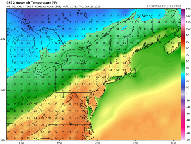
GFS mid to upper 70s Christmas Day. Euro gets a small front through on Christmas but 70s on Christmas Eve. Yuck
-

December 2025 regional war/obs/disco thread
Damage In Tolland replied to Torch Tiger's topic in New England
I’m fully expecting 3-5” inch type deal of fluff . Small chance it amps more , but as of now that’s what it looks like -
I was thinking the opposite. Imo it has some boom potential, especially from AA County NE towards South NJ. It doesn't look great for the snow drought areas.
-
Santa got his shorts for Christmas?
-

December 2025 Short/Medium Range Forecast Thread
Carvers Gap replied to John1122's topic in Tennessee Valley
That post was from November 21st as an example of how quickly things changed(back to cold) in modeling. I was commenting at the time about a standing wave which never materialized in reality. I will have some comments hopefully this morning about the possible upcoming pattern change to a ridge over the East. And yes, I do think it is probably a pattern change which will last through the last ten days of December and through most of January....but that isn't a slam dunk just yet, but more of a strong likelihood. -

Minor snow possible sunday 12/14/25
MJO812 replied to WeatherGeek2025's topic in New York City Metro
Euro shifted slightly north with the precip. 1-3 inches is a good call. Nice little event before it warms up -

Central PA Winter 25/26 Discussion and Obs
Superstorm replied to MAG5035's topic in Upstate New York/Pennsylvania
I feel the weekend we will see a snow event marking the start of the pattern change to warmer weather. . -

December 2025 regional war/obs/disco thread
Snowcrazed71 replied to Torch Tiger's topic in New England
Do like I did with him and a few others. I just blocked him. He won't stop and he will not be flagged. J -

Minor snow possible sunday 12/14/25
BxEngine replied to WeatherGeek2025's topic in New York City Metro
Regionwide in the next region south of us…. -
Troll should be 1 posted
-
Sign me up as well.
-

Central PA Winter 25/26 Discussion and Obs
mahantango#1 replied to MAG5035's topic in Upstate New York/Pennsylvania
Took this pic yesterday afternoon when it was snowing. The creek is freezing over. Imperssive for this time of year. -
06z euro improved again after the regression at 00z. I don’t think this one has a high ceiling though. There’s just not enough room. But it could be a solid advisory event maybe.
-
Still looks good for DC
-
December 2025 regional war/obs/disco thread
Snowcrazed71 replied to Torch Tiger's topic in New England
Well, I guess things went south overnight. Sucks. -

Winter 2025-26 Medium/Long Range Discussion
A-L-E-K replied to michsnowfreak's topic in Lakes/Ohio Valley
looking at the eps this morning -

December 2025 Short/Medium Range Forecast Thread
Holston_River_Rambler replied to John1122's topic in Tennessee Valley
URGENT - WINTER WEATHER MESSAGE, HOLSTON'S WEATHER EMPORIUM, Mossy Grove, TN 6:30 AM EST ****YE OLEN CLIPPER WARNING*** * WHAT...Light to occasionally moderate snow. Snow accumulations 1 to 4 inches, greatest across higher terrain. Winds gusting as high as 7 mph will produce pretty sights. * WHERE...Eastern KY, SW VA, and possibly Bristol, TN and Mountain City, TN The greatest additional accumulations will focus across the higher terrain of the High Knob and peaks on the KY and NA border above 2500 feet. * WHEN...Starting late this evening * IMPACTS...Plan on some snow covered and slippery road conditions as well as the comfortable ease of a clipper's accumulations. Hot chocolate is recommended for these trying times. SUMMARY...SW VA and eastern KY is in danger of getting hit by the first traditional clipper to hold together all the way to the southern Apps region in what seems to me like 7.5 million years. Some of the Hi Res models clip extreme NE TN too. Pretty much all the Hi Res models show the same thing, even the ever stingy NBM.


