All Activity
- Past hour
-

White Christmas Miracle? December 23-24th
weathafella replied to Baroclinic Zone's topic in New England
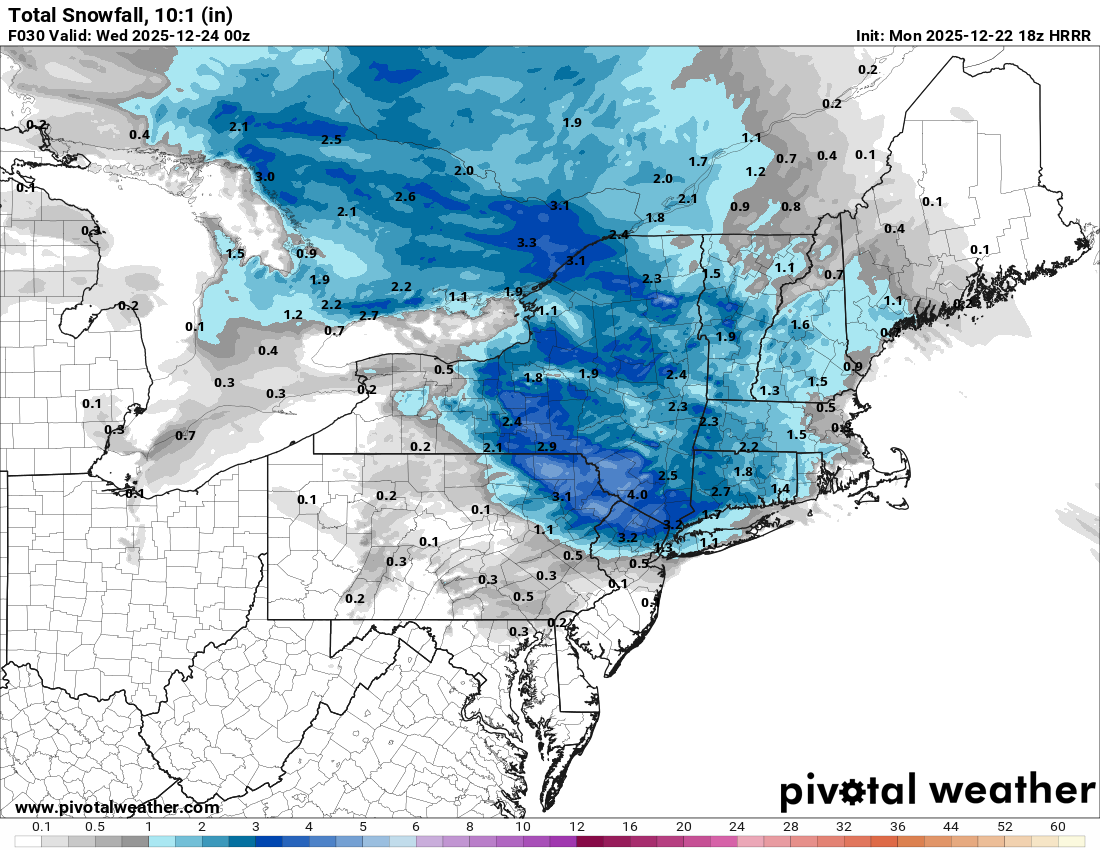
NAM is hitting much of sne into NNE in the 18z run. -
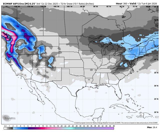
Also on AIFS ens.... please remember we seem to have pretty much decided it can't tell the difference between snow/IP/FRZA/etc - but I see this as the total amount of wintry precip it's seeing for Friday. Just gotta mentally convert it to a QPF map
-
i am seeing weenies post this map on social media. It looks like a combo of the 93 blizzard and blizzard of 96. Who gave JB the autopen?
-
 Hrrr too
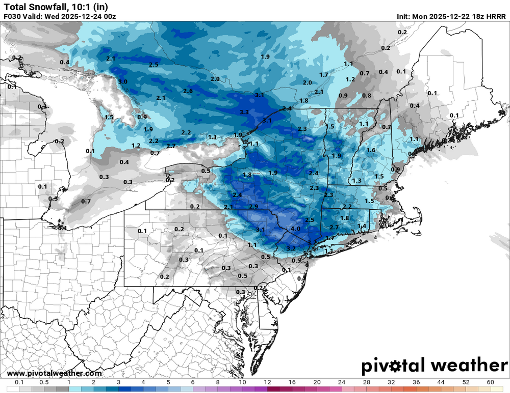
-

2025-2026 ENSO
PhiEaglesfan712 replied to 40/70 Benchmark's topic in Weather Forecasting and Discussion
lol, January isn't coming close to 21 inches of snow. The snowiest January since the 2016 storm was 2022, and that was 15.3 inches, and 2018 is the only other year since then that has even topped 10 inches. I'd be willing to bet that January ends up with less than 10 inches of snow and an above average temperature departure. -

Mid to long range discussion- 2025
Leesville Wx Hawk replied to wncsnow's topic in Southeastern States
We sure do. Let’s see how it trends? My guess is that it won’t move much further. Canadian Ensemble mean showing extended GOA to Baja which isn’t a terrible look with Greenland blocking. It’s a crap shoot right now LOL. . -
12z Euro ENS try to kill the western Canada trough around New Years and dump a respectable eastern US trough on us. Maybe this warmup will be muted?
-
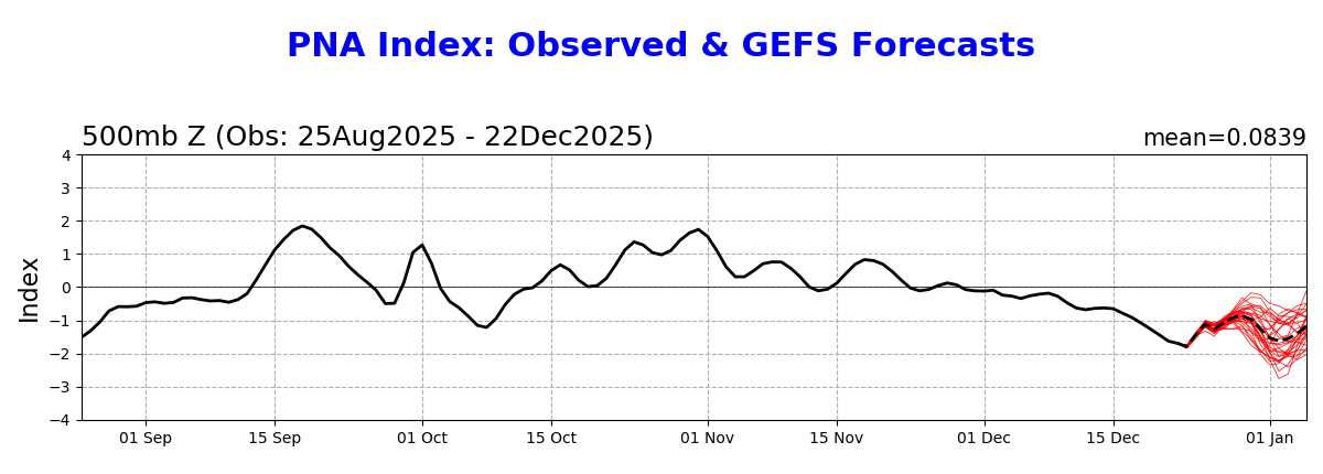
August 1st through December 21st has averaged 60.7°F at DCA, the coldest for that stretch since the year 2000 (58.4°F), and 1.5°F below the 30 year average.
-

December 2025 Short/Medium Range Forecast Thread
Matthew70 replied to John1122's topic in Tennessee Valley
NWS is sure on the ball issuing dense fog advisories. Already one for Christmas Eve. -

White Christmas Miracle? December 23-24th
The 4 Seasons replied to Baroclinic Zone's topic in New England
Here comes the cracked out NAM run, jacks SW CT and LHV. -

Occasional Thoughts on Climate Change
TheClimateChanger replied to donsutherland1's topic in Climate Change
-
 Careful predicting anything this far out. Models have been horrendous in the long range.
 -

White Christmas Miracle? December 23-24th
Lava Rock replied to Baroclinic Zone's topic in New England
But I know what you really mean -

Central PA Winter 25/26 Discussion and Obs
Itstrainingtime replied to MAG5035's topic in Upstate New York/Pennsylvania
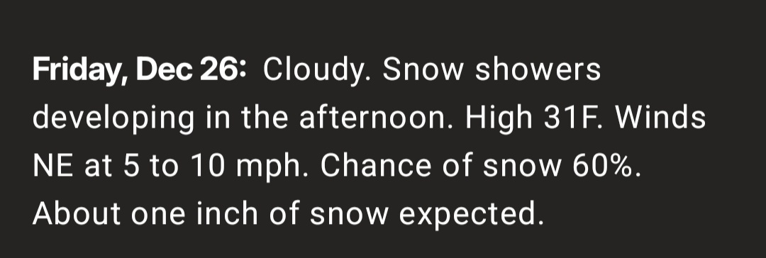
Not bad - CTP dropped my projected high for Friday from 58 to 37 in about 12 hour's time. Depending on the strength of the high, it might go even lower. -
Nam increased amounts along the coast
.thumb.png.984308b781ef9dd7dababb5bd54854d0.png)
-
Occasional Thoughts on Climate Change
TheClimateChanger replied to donsutherland1's topic in Climate Change
-
Deep range but AIFS is lit up at the very end of the run. Quite a signal for days 14-16… mock it all ya want.
-
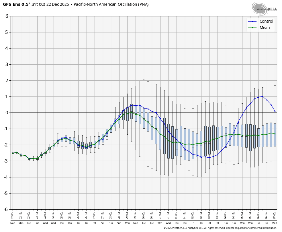
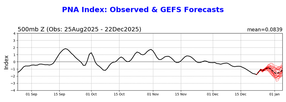
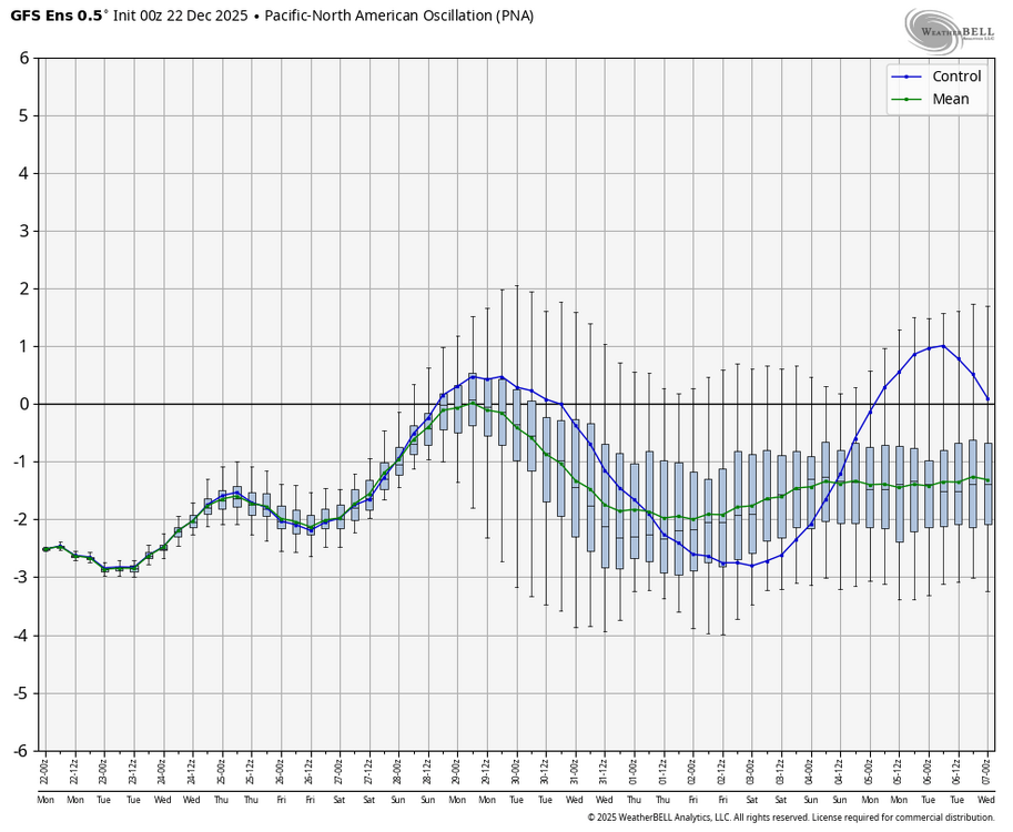
Even though I posted the WxBell charts, I admit that there are often discrepancies in their tele charts vs NOAA. For example, check out the initializations: NOAA is -1.8 today (which is what’s actually listed for today) and it’s forecasted to rise to -1.5 tomorrow. But WxBell has -2.5 today and with it headed down to -2.9 tomorrow! It seems like WxBell often has wider variations up and down among other things.
-
 WWA here from 4am to 4pm. Expecting 2-3” here, a smidge less than the last storm where I had almost 5”. This is proving to be one of my snowiest Decembers in recent history. I hope we can get a KU out of this pattern before it snaps. January is looking like a torch for most of the country.
 -
 Forecast high: 39 high so far temps ranging from 36.5 on my station at parents and 35.8 at my house, both of which temps are dropping.
 -
Anyone check out the cold over NW Canada? Currently -40's to -50's F over Yukon and NWT. Even a few spots at -60F currently. Mid to LR forecasts continue to build the cold over the next week. Where it goes beyond that is the question. Does it stay bottled up in Canada and slide more east than south or does in make a run south into the U.S. either is pieces or a large Arctic plunge? I think all options are on the table but something worth following.
-
December 2025 regional war/obs/disco thread
The 4 Seasons replied to Torch Tiger's topic in New England
"...And Papi with the walk-off home run! We're goin to game 5." -
The Weather Channel already has it lol
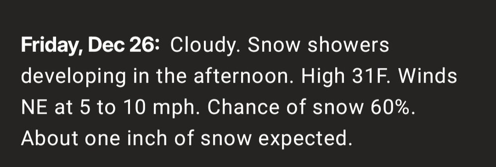
-
It sure is. I already posted after the first storm a prediction of 21” minimum for Jan+, alone, on top of whatever Dec ends up with.
-

White Christmas Miracle? December 23-24th
TheMainer replied to Baroclinic Zone's topic in New England
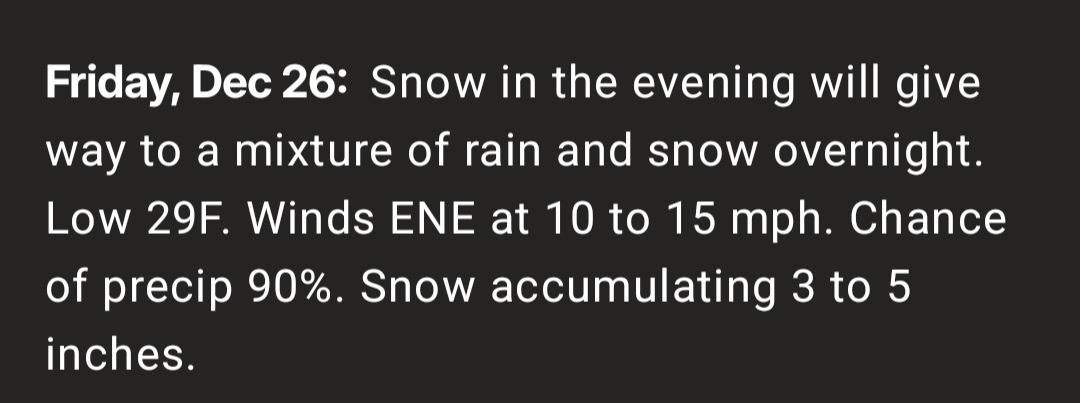
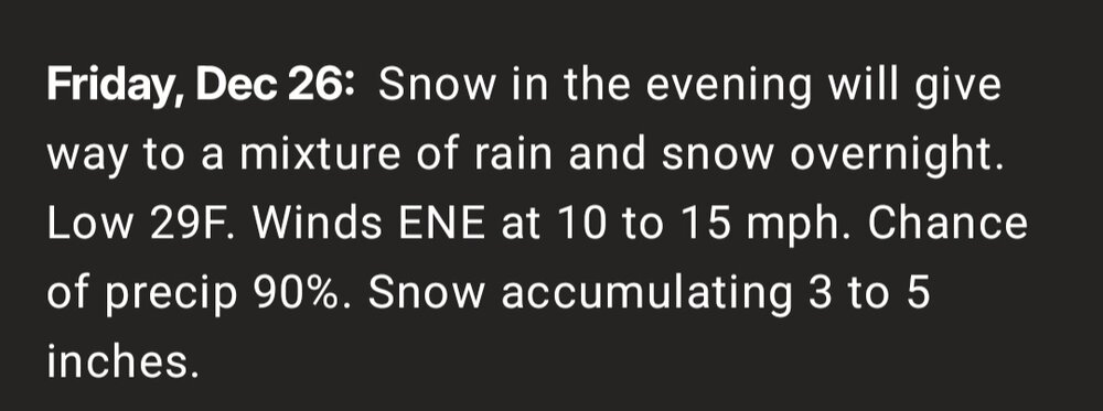
I'll take my 3-5 inches and let the southern Maine guys have the fun, I think we're in a slightly better position as things play out in the longer term


.png.1f4b549a441ae8aa458a5d624b66f6e9.png)