All Activity
- Past hour
-
I'm hugging the RGEM so hard that it has difficulty breathing.
.thumb.png.8921ee84b51765575a8e2afee775fb81.png)
-
I didn’t know that. That’s surprising to me. It usually takes until sometime in May for it to be warm enough for dandelions around here. I usually don’t have to cut my lawn until May though either so I guess NYC is like San Juan compared to here when it comes to plant life. lol
-
Chuck was high on this period I think before you, me, and PSU. I think a Chuck storm might be exactly what we need. But if he makes a single post about a negative fucking PNA it automatically gets transferred to someone else.
-
I feel confident that we have the equipment already in place in Kingsport which can seed clouds. Those little ground based, propane powered silver iodide dispersers...ain't got nothin' on the thermal ability of the Model City.
-
YOS.
-
I'm hoping for more than mood flakes on Sat as I expect that to be the snowier day for me. I think LI and southern NJ has a decent shot of accumulating snow on Sun. But I'm not closing the door on a significant west trend.
-

Storm potential January 18th-19th
Brian5671 replied to WeatherGeek2025's topic in New York City Metro
Round and round we go...but think a small event is in order here -
RGEM very westerly.
-
The model thats gonna replace the NAM the RRFS A.

-
Toss. (Except for model huggers. Enjoy the next 6 hours.) Our flagship American model is just as unreliable.
-

Storm potential January 18th-19th
WeatherGeek2025 replied to WeatherGeek2025's topic in New York City Metro
reggie is rain to long lasting snowstorm 4-5 inches -

Another Coating of Snow Saturday - "It's all we Got"
CoastalWx replied to Sey-Mour Snow's topic in New England
Reggie west. Let’s sacrifice Saturday for Sunday night -
First Legit Storm Potential of the Season Upon Us
CoastalWx replied to 40/70 Benchmark's topic in New England
I just looked. Nice little event -
Lovely write up. For a change I don't think it's all hype and BS. I seem to remember this feedback loop being enhanced when PVA tracked close to the Gulf states and picked up additional moisture inflow... which is what is forecast by most models to occur.
-

January 2026 regional war/obs/disco thread
dendrite replied to Baroclinic Zone's topic in New England
34 and ripping -GSSN -
My temp didn’t go above 31 this afternoon and at 4:30 already down to 27.5
-

Storm potential January 18th-19th
Tar Heel Snow replied to WeatherGeek2025's topic in New York City Metro
This is a wildly difficult forecast. I mean it could literally be nothing outside of some Saturday mood flakes or we could see legitimate accumulations closer to the coast. I don’t envy the Mets who have to communicate this stuff to the public. -
18z RDPS further West with more moisture, but too warm at the surface for most east of 77.
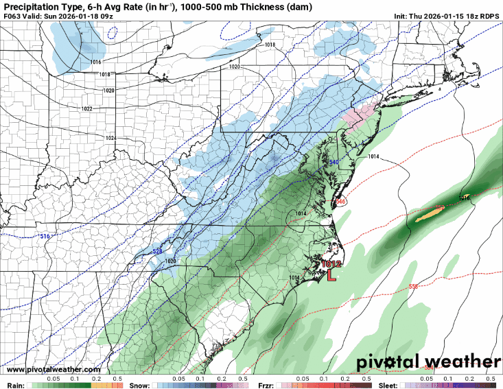
-
So we've moved on to the next head fake have we? Ok, cool. Count me in. Ya know, we do this to ourselves.
-

Central PA Winter 25/26 Discussion and Obs
Mount Joy Snowman replied to MAG5035's topic in Upstate New York/Pennsylvania
Thank you good sir. Yes, I’ve been to that Brimmer’s a number of times over the years. Today I just went to the Rohrerstown DMV and believe it or not I was in and out, got there right when they opened. ‘Twas quite pleased. I believe you have to go to a PennDot center for real ID, so no dice on Brimmer’s. -
So our options are so far out to sea or so far west it’s rain?
-
We need you to come wade through our mess and be the voice of reason. You know how we get when there’s model madness. In the same boat as many of you! Hang in there, we’ll score eventually. Mother Nature hasn’t been too kind for eastern Tenn through the foothills of NC.
-
I love how it's snowier than 12z. Lovely model battle
-
I have always hated the Germans.
-
Storm potential January 18th-19th
Tar Heel Snow replied to WeatherGeek2025's topic in New York City Metro
From Eric Webb (aka my current hopium dealer) There are positive feedbacks between warm advection, precip, latent heat release, and wave tilt/amplitude that a lot of, if not most, models are going to miss in setups like these, which make them especially tricky to forecast. It’s easy for a lot of people and forecasters alike to get caught up in the models and underestimate the effect these processes and the magnitude of impact they can have on even a short range forecast. This positive feedback loop involves warm advection and upglide aloft generating more precip and latent heating, which force -PVa ahead of our upper trough, causing the wave to slow and tilt the over more negatively/less positively. The increased wave tilt is able to advect more warm/moist air aloft over the Arctic front, which triggers more precip, etc.When your air mass is super marginal like this and the large-scale flow is diffluent downstream (ridging off Newfoundland), you’re even more vulnerable to this positive feedback running away in a hurry and amplifying the short-term changes in the models. This is just the kind of recipe that can lead to big forecast busts, especially on the north & west side of these systems where the warm advection is weaker but also closer to the snow growth zone aloft

.png.d38ed8486099afc97138275ab8c7e910.png)


.thumb.jpg.9707d4addca3d84715ae3d888c5c10d6.jpg)