All Activity
- Past hour
-
A buddy down there improvised and tied a telephone pole to his backhoe and used it as a rake to move hail.
-

Texas 2024 Discussion/Observations
Powerball replied to Stx_Thunder's topic in Central/Western States
Spoke too soon. May 2024 will tie for the 10th warmest on record. -
no real heat this upcoming week so i am happy...
-

Texas 2024 Discussion/Observations
donsutherland1 replied to Stx_Thunder's topic in Central/Western States
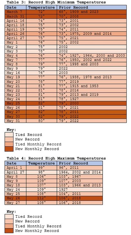
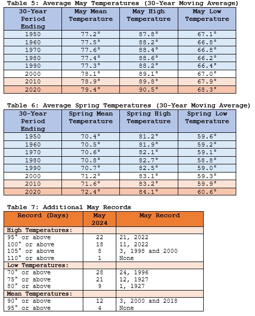
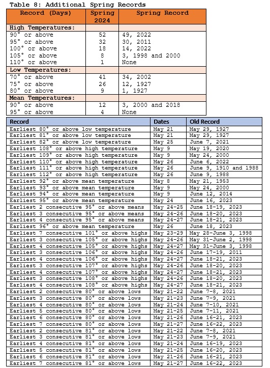
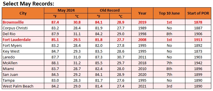
Brownsville experienced its warmest May on record. Brownsville's May was also warmer than any June on record. Some records from Florida, Puerto Rico, and Texas: Del Rio demolished its May and Spring records. It also had its first May extreme heat event (Clarke et al., 2014 methodology) on record. Some highlights from Del Rio: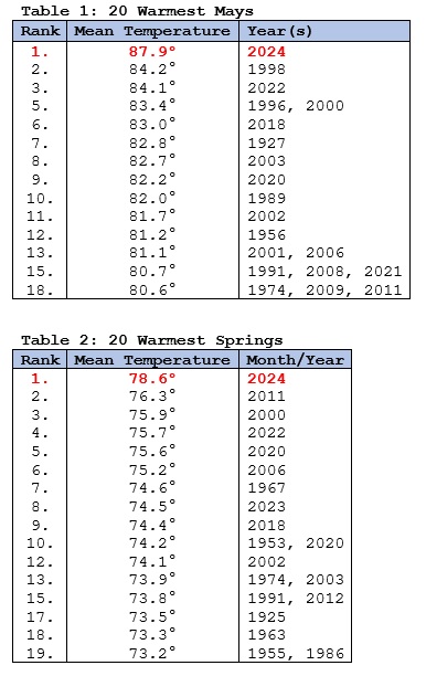
-

Central Pa. Spring 2024
Mount Joy Snowman replied to mahantango#1's topic in Upstate New York/Pennsylvania
Low of 50. Another 10 forthcoming. -
Hi Don, All valid data points are meaningful....like this one. That does not of course imply that during our current warmer cycle that likely lower mean highs offset by higher mean lows will show overall warmth.
-

Texas 2024 Discussion/Observations
Stx_Thunder replied to Stx_Thunder's topic in Central/Western States
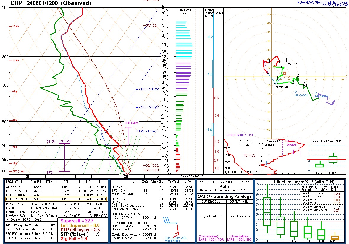
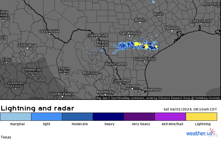
12z CRP obs sounding this morning is convectively primed with a P. Only caveat is a bit of 700Mb warm nose. - - - Will see how much of that built-up energy is used today/night, but already seeing a line of cells popping up fairly quick in the past hour just south of San Antonio - near Victoria, with an outflow coming from the overnight upstream MCS activity in the panhandle and western hill country. There appears to be a decent mid/upper shortwave approaching the region from the west on 12z UA compiled data this morning also (decent area of 300Mb divergence just west of middle Rio Grande).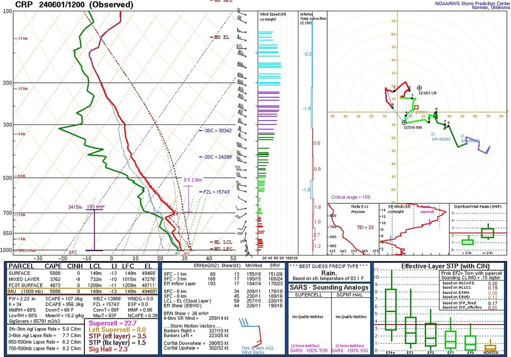
-

May 2024 Discussion - Welcome to Severe Season!!!!
tamarack replied to weatherwiz's topic in New England
Another morning near 40. While we were in SNJ celebrating the HS graduation of our oldest granddaughter, it rained one night (7th) plus a shower on the 29th. Back here, the max-min showed a high of 75, low of 38 (prob. 30th) during May 25-31. Had 1.76" during the period, with other sites indicating it came all/most on the 27th into early 28th. Had a great trip, including a journey to Lancaster PA on the 30th to pick up rustic furniture for the family's new enclosed porch. Coming home yesterday, hit a real mess on I-495; shortly after we came onto it from I-290, the update sign said 26 miles to I-93, estimated 62 minutes - not good. And we didn't get clear of the stop-n-go until Haverhill. No cause seen, just too many cars. -

Mid to Long Range Discussion ~ 2024
WinstonSalemArlington replied to buckeyefan1's topic in Southeastern States
Last evening while walking out, I felt that “nip in the air” feeling of October. It will be back to stay in less than four months. -

Occasional Thoughts on Climate Change
Typhoon Tip replied to donsutherland1's topic in Climate Change
I find the suppression in latitude fascinating - not a climate introspective, but for the Meteorology. The pattern foot so far this spring has been limiting expansion, perhaps masked by seasonality. In other words, folks would be inclined to suggest 'Hey, it's only May'. Yeeeeah, but I suspect there's some relativity going on. My personal suspicion is that the background planetary environment passed through a global threshold at some point over the last 10 years - together with some fantastic singular warm anomaly events, when then aggregating those synergistic heat bomb phenomenon together with the early in 2023 total GW spike ( air and sea, everywhere!) ... I just think we're staring at a duh situation trying to understand the specter so vast the boundaries of which are just very obvious. Kind of like a deer caught the headlights cliche ( so to speak..) But maybe given time any such threshold to be defined. Within the confines of that new paradigm, we should be seeing more of these heat expansions prior to the solstice insolation - that's the relativity, in that we may merely be seeing a suppression of that new norm, endemic to this spring. I'm looking at the long lead telecons, out through the third week of June, and suppression of 'big heat' and/or SW expulsion events, N-E of St Louis ( ~ ) is favored. Yet if that is materialized in the spatial synoptics ... I have a funny feeling that Mexico to Florida and S. TX ...possibly as high as Dallas to Alabama and the Carolinas from time to time, may swelter while ORD-BOS is mollycoddled with temperate spoils. -

Pittsburgh/Western PA Spring 2024
TheClimateChanger replied to Ahoff's topic in Upstate New York/Pennsylvania
Yes, warmest and second wettest meteorological spring on record. -
New thread for summer.
-
This SSTA animation is showing very well defined tropical instability waves (“TIWs”), which are indicative of real healthy La Niña event developing. Enhanced trade winds and easterly wind bursts usually follow. To me, this suggests that at the very least, a moderate event becoming more and more likely. It is forming more rapidly than both ‘98 and ‘10 were at this point in time
-
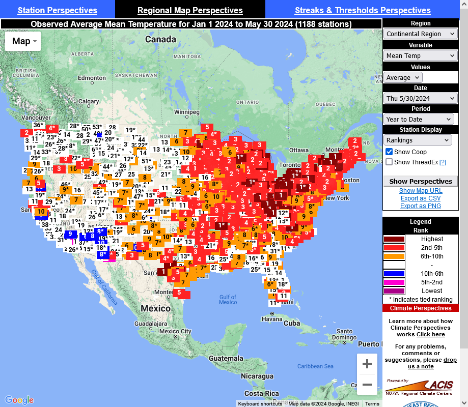
Nope. He is tracking the daily temperatures on ACIS. Here's the year to-date from ACIS

-
My goodness that looks like snow!
-
41 degrees this morning. The coolest June 1 in 40 years! In 1984 it was 39.
-
of course.....with the adjustments applied to arrive at the official altered data.
- Today
-
The Newark last week of May including Memorial day weekend summer preview maximum temperature came in on the lower side since 2010 not reaching 90°. If the summer patterns since 2010 remain in effect this year, then it means that Newark may be able to avoid a top 10 warmest summer for 90° day count and average temperature. The years under 90° during the last week of May are bolded. The temperature departures for the similar summers were -0.4 to +1.9 with the 90° days between 15 and 31. So if this late May to summer pattern holds, it suggests Newark won’t see the typical 40+ days reaching 90°+ as was the case during the previous El Niño to La Nina transition summers in 2016 and 2010. It also means that it could avoid a top 10 for warmest summer for average temperature and number of 90° days. Time Series Summary for NEWARK LIBERTY INTL AP, NJ Click column heading to sort ascending, click again to sort descending. Ending Date Highest Max Temperature May 25 to May 31 Annual # 90° days +Departure +top 10 ranking 2024-05-31 84 ? 2023-05-31 80 29….+0.6 2022-05-31 98 49…+3.5…#1…warmest summer #2 for 90° days 2021-05-31 94 41….+2.6….#4…warmest summer…#4 for 90° days 2020-05-31 86 31…..+1.9 2019-05-31 90 27….+1.3 2018-05-31 92 36….+1.3….#8 for 90° days 2017-05-31 80 22 2016-05-31 96 40….+2.4…9th warmest summer #5 on 90° days 2015-05-31 91 35…..+1.4……#9 on 90° days 2014-05-31 88 15…..-0.4 2013-05-31 94 25….+1.1 2012-05-31 92 33….+1.7 2011-05-31 92 31….+2.8…5th warmest summer 2010-05-31 95 54….+3.5….2nd warmest summer and #1 for 90° days
-

Mid to Long Range Discussion ~ 2024
Upstate Tiger replied to buckeyefan1's topic in Southeastern States
I posted in obs that it was 47 this morning in West Lincoln County. Pretty amazing to be less than 5 weeks from July 4. Love it. Pic from last evening sitting on deck waiting on deer. Almost needed a sweater.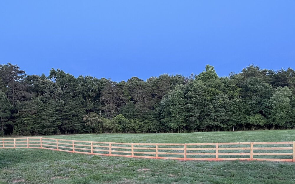
-
Occasional Thoughts on Climate Change
donsutherland1 replied to donsutherland1's topic in Climate Change
Numerous U.S. cities had their warmest #May on record, some by tremendous margins. In a number, May 2024 would have ranked among the 10 warmest Junes on record. In Brownsville and Fort Lauderdale, the May temperature exceeded both the May and June records.
-
47 this morning in West Lincoln county. Wow.
-
It was a passage I had found in a 19th century US climate book, quoting a person who witnessed it.
-
Nice site for solar activity. https://solen.info/solar/index.html
-
58 was my low. Off to Arlington for a funeral. Hope it’s not too muggy in the fishbowl.