All Activity
- Past hour
-
(002).thumb.png.6e3d9d46bca5fe41aab7a74871dd8af8.png)
Central PA Fall Discussions and Obs
ChescoWx replied to ChescoWx's topic in Upstate New York/Pennsylvania
Quite a few stations across Chester County have remained in the 25 to 27 degree range for maximum temperatures so far today. If temperatures don't rise much more before midnight today will finish in the Top 3 coldest December 5th daytime highs since records began in 1893. So far here in East Nantmeal our high has been 25.7 degrees we are currently at 25.4 degrees. Below are the top 5 lowest max temperature days.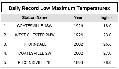
-
No that's just an add on.
-

Winter 2025-26 Short Range Discussion
mimillman replied to SchaumburgStormer's topic in Lakes/Ohio Valley
Individual SREF members are kind of all over the place -

Central PA Fall Discussions and Obs
Ruin replied to ChescoWx's topic in Upstate New York/Pennsylvania
Ro far away atm -
12/11 looks like crap....prob just a FROPA....maybe a few showers (maybe some wet snow interior higher terrain if we dont get the BL torched too much ahead of it)....you are prob thinking of the one behind it 12/12-13.
-
E PA/NJ/DE Winter 2025-26 Obs/Discussion
ChescoWx replied to LVblizzard's topic in Philadelphia Region
Quite a few stations across Chester County have remained in the 25 to 27 degree range for maximum temperatures so far today. If temperatures don't rise much more before midnight today will finish in the Top 3 coldest December 5th daytime highs since records began in 1893. So far here in East Nantmeal our high has been 25.7 degrees we are currently at 25.4 degrees. Below are the top 5 lowest max temperature days.
-
salt in the wound for you. have a beer
-
Everything earlier today stayed south of here. First snow of the day now. Decent shower with big flakes. 28°.
-

December 2025 regional war/obs/disco thread
Damage In Tolland replied to Torch Tiger's topic in New England
As of this morning the talk was ls that was snow -

December 2025 regional war/obs/disco thread
SouthCoastMA replied to Torch Tiger's topic in New England
Yeah - selling anything before 12/13 at this point. CMC ENS had a couple big hits. -
December 2025 regional war/obs/disco thread
SouthCoastMA replied to Torch Tiger's topic in New England
Looking forward to my inverted trough rain shower -
March 1st of 09, was one of my favorites as well, first time seeing thunder snow. Was a quick hitting upper low pivoting up from ATL and crushed parts of Catawba County with nearly 8"+ of heavy wet snow. All fell from 5-6 pm and was done by 11 pm. Trees were absolutely beautiful.
-
That 12/11 clipper is basically a glorified FROPA at this point if its gonna track into CYUL But EPS looked better for the 12/12-13 threat behind it. That had some decently snowy members in there.
-
Damn must be 1 free article
-
@SnowenOutThereafter those beautiful dendrite conglomerates earlier, getting some snow grains and needles now with these very light returns
-
Cause most models show it.
-
December 2025 regional war/obs/disco thread
Damage In Tolland replied to Torch Tiger's topic in New England
Why is Box talking about rain end of week? -
That was some of my highest snow drifting in Long Beach since February 78.
-
Accumulating snow line was 10 miles from here too lmao let’s hope everyone who missed gets it tonight
-
On the 18z run the HRRR continues to show some snow showers delivering maybe a half inch for this area overnight. Hopefully it's correct and we wake up to a nice little coating of snow tomorrow morning.
-
12/5: 1.8”
-
The radar of that upper level energy pivoting through was something else! Definitely the best two part system of recent memory. I lived in Maiden at the time and we only had 4-5 inches out of day one, turned to sleet that night and the next morning we picked up 6"+ out of the upper low in about 4-5 hrs. Great storm!
-
December 2025 regional war/obs/disco thread
Damage In Tolland replied to Torch Tiger's topic in New England
Again ? -
Dec 2018 (above) will be hard to replicate but 4 years earlier is still the goat for me. That Valentines storm in 2014, I was living in Mt. Airy and day 1 was cool but as the storm was departing, we got under that upper level death band and watched us eclipse day 1 totals in a quarter of the time. By far the heaviest snow I’ve ever witnessed. Believe we came close to 20”. .
-
Unfortunately, it looks like we might have to shut the blinds for a bit over here. Both of the next clippers will likely head to our north, with maybe some light rain for our area. On the backside, cold and dry once more. Colder than normal weather seems to be nearly guaranteed for the foreseeable future. But no snow in sight.


