All Activity
- Past hour
-

Winter 2025-26 Medium/Long Range Discussion
Baum replied to michsnowfreak's topic in Lakes/Ohio Valley
Salt shortages everywhere. Same as last season. Not sure why. Won’t be long rivers will freeze up and get shipments down river. -

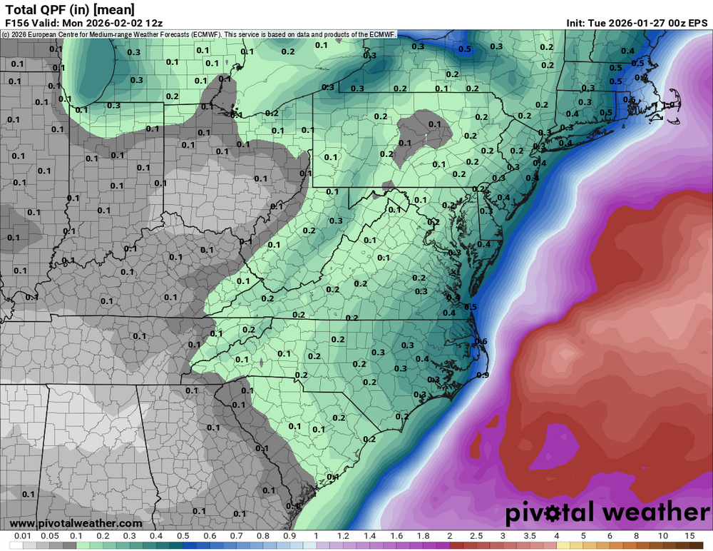
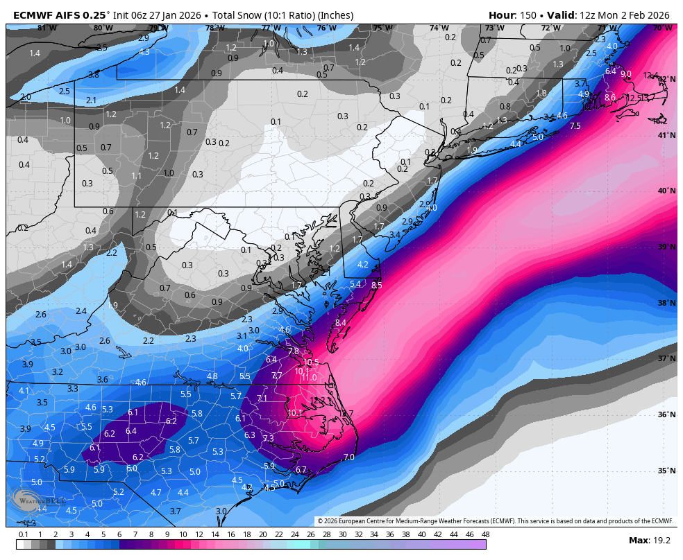
Possible coastal storm centered on Feb 1 2026.
Kitz Craver replied to Typhoon Tip's topic in New England
I just think within that ENS spread we would see some serious eye candy on OPs(well we did have that on the Canadian yesterday) I dunno, I just don’t like the double barrel low look as of late -

Possible coastal storm centered on Feb 1 2026.
ineedsnow replied to Typhoon Tip's topic in New England
GEFS are great! -

The “I bring the mojo” Jan 30-Feb 1 potential winter storm
timnc910 replied to lilj4425's topic in Southeastern States
Looking at the 6z icon it did appear to come back west quite a bit compared to 0z. -

The “I bring the mojo” Jan 30-Feb 1 potential winter storm
Snowncanes replied to lilj4425's topic in Southeastern States
6z euro AI looks a few ticks better at 5H. Goes neutral a little earlier and negative a little further SW -

E PA/NJ/DE Winter 2025-26 Obs/Discussion
MJO812 replied to LVblizzard's topic in Philadelphia Region
Gefs looks great.thumb.png.3ba4c4acb9b83b2eef7e13639cb169ce.png)
-
Why is it odd ? Its still 5 days out.
-

E PA/NJ/DE Winter 2025-26 Obs/Discussion
Violentweatherfan replied to LVblizzard's topic in Philadelphia Region
It all depends on how much the surface low deepens off the coast. Anything sub 990 it’ll tuck and hug the coast. All of these sub 990/980 SLP going out to sea are hogwash. My concern is how strong the HP west of it is, along with the HP in Quebec might be nudging it OTS -
No one does, but this last storm showed big hits lots of snow for the area. Once data start getting injested things changed from big snows to a lot of sleet and freezing rain. What did the models for this storm? Something this far out big hits of snow and now moving to more ENE. Just my observation
-

Richmond Metro/Hampton Roads Area Discussion
eaglesin2011 replied to RIC Airport's topic in Mid Atlantic
The RIC is definitely again right on the line of a Major hit & a complete miss.. I was hoping that these early morning models would clarify this all more but it looks like it’s going to take until at least this little clipper goes through tomorrow for the models to come into more of agreement… -
WB 6Z EURO AI no change.

-
Possible coastal storm centered on Feb 1 2026.
Kitz Craver replied to Typhoon Tip's topic in New England
With almost all ENS leaning west with some really tucked and strong SLP’s even more west. It’s odd to me that every OP is skirting this off the coast and exit stage right. -
Thank you and yep about to go to the dealer for when they open.
-
Yes
(7).thumb.png.d3e0162234708b291445ab4fc56d57c5.png)
-

Possible coastal storm centered on Feb 1 2026.
Roger Smith replied to Typhoon Tip's topic in New England
Yep, the same low 100 miles east of Nantucket instead of 100 miles east of s DMV would give e MA what this model run gives Norfolk (30" snow). A track up towards Long Island and then over the islands and cape, with those pressures and air masses, would be a BECS like 1888. Or maybe it stalls where the Bliz of 78 stalled. Of course maybe none of the above, but I think this early in the winter season a block and a right turn are not realistic, that is March into April sort of weather. -

Possible coastal storm centered on Feb 1 2026.
Damage In Tolland replied to Typhoon Tip's topic in New England
Even without a direct hit it would snow for everyone -
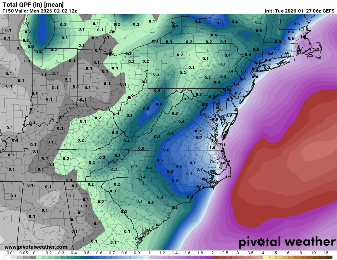
Wow big jump west by the 6z GEFS. The mean shows a nice hit for a lot of the area.
-
6z mean isn't bad. Better than 0z.
-

Possible coastal storm centered on Feb 1 2026.
CoastalWx replied to Typhoon Tip's topic in New England
Kind of an occluded mess on models. Although the precip arc would have the goods. -

Winter 2025-26 Medium/Long Range Discussion
A-L-E-K replied to michsnowfreak's topic in Lakes/Ohio Valley
Riding it^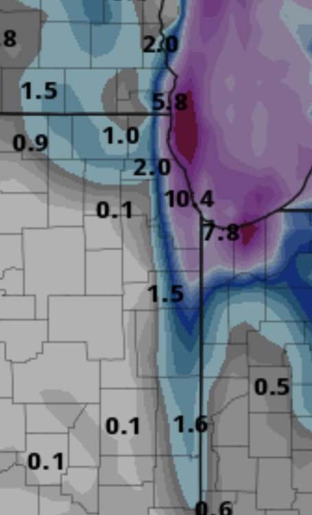
-

The “I bring the mojo” Jan 30-Feb 1 potential winter storm
BooneWX replied to lilj4425's topic in Southeastern States
I believe the chart I had was shared by a meteorologist on X more familiar with the westhernext suite, so I’ll see if I can find that. -

The “I bring the mojo” Jan 30-Feb 1 potential winter storm
olafminesaw replied to lilj4425's topic in Southeastern States
Confidence growing for a light to moderate event across central NC. Still relying on early phasing for the higher totals (6" +)

-
 .5 after the 8pm clearing, 17.3" total for the storm
 -
This is guaranteed to get me weenied but I want to see a storm as bad as most of you but can a sub-980mb please not verify because that would be insane for this time of year and be a huge problem.
-

E PA/NJ/DE Winter 2025-26 Obs/Discussion
MickeyTim6533 replied to LVblizzard's topic in Philadelphia Region
this one seems like a southeast special. 6Z stalls off the Carolinas then heads ENE, squat for our area, need negative tilt and there isn't any. clock is starting to become a factor on this one.
.png.b09d7883c0df2a146c4cb25987b12764.png)


(7).png.4278e0737aca6ecf13e2464196189ff4.png)