All Activity
- Past hour
-
Heh... despite my conservative tone this morning - which I still suspect is warranted - the NAM arrives with a 90 F at least implicated in the FOUS grid 54000492730 -2403 212012 71261912 I don't expect anyone to know what these numerics are supposed mean - mainly because I've written, with pain staking detail, what those definitions are at least 20 times ( ). Anyway, that profile for 18z on Wednesday would 89 to 91 over down town streets and parking lots...ranging to 82 or 84 where the hill people down play heat. sarcasm aside ...I'm not sure the NAM physics has smoke contamination built in ? maybe Brian or someone knows.
-
Another chilly one this morning. Some notable lows: 32F, at Zelienople: National Weather Service 35F, at Cambridge, Ohio: National Weather Service 36F, at New Castle: National Weather Service 36F, at Butler: National Weather Service 36F, at DuBois: National Weather Service 36F, at Indiana: National Weather Service 37F, at Washington: National Weather Service 37F, at Franklin: National Weather Service 37F, at Connellsville: National Weather Service 38F, at Zanesville, Ohio: National Weather Service 39F, at New Philadelphia, Ohio: National Weather Service 39F, at Latrobe: National Weather Service 40F, at Morgantown, W. Va.: National Weather Service 40F, at Wheeling, W. Va.: National Weather Service 40F, at Pittsburgh: National Weather Service 41F, at Allegheny County Airport: National Weather Service
-
Yeah... we were around 9.25-9.5" in my hood for May. Dewy
-
minus the late may period, spring was great.
-
Part of a tree is on the roof of friend's garage out near Linglestown. It was wild - the city itself didn't see much issue this time with the wind somehow.
-
He isn’t saying NYC will never have a good winter again unless we have another Pinatubo or Yellowstone blows up (in which case we have more serious problems lol). We had a pretty good one in 2020-21. But we’re definitely in a steep downturn overall and it’s fairly easy to see why-it’s being ruined largely by the W Pacific on steroids. To me there’s not much if/but or deep analysis needed and it makes a lot of sense as much as I hate it. Reality doesn’t care. We see time after time decent setups literally blown/sheared apart by the fast Pacific jet or the ridge/trough orientation pushed too far east, or the SE ridge takes over and we get lousy cutters/SWFE that can be great for I-90 and the Lakes but horrendous here. You can just see how it keeps evolving. Until that base state changes where we’re in either a defined Nina or quasi-Nina with the warm W Pacific which cancels out even strong El Niño, I don’t see how our outcomes change. There can be a winter like 2020-21 every once in a blue moon in this state where other factors can overcome it but it will be the exception.
-
3 closet Davis stations to my house had 9.66, 9.89 and 10.21 inches for the month. No wonder I have mushrooms growing all over the yard.
-
All my vegetables are going to bolt with this heat
-

2025-2026 ENSO
PhiEaglesfan712 replied to 40/70 Benchmark's topic in Weather Forecasting and Discussion
Our last major volcanic eruption was Mt. Pinatubo (in 1991), but we didn't really get the full effects of the cooling due to a strong el nino. Just the fact that it was able to cause any type of cooling, despite the strong el nino, should tell you how strong that volcanic eruption was. If Pinatubo happens ahead of strong la nina, like in the summer of 2007, there's no doubt in my mind we would have had a longer lasting temporary cooling period. -
Maybe I am blind, but I am not seeing a true heat signal yet. We have a few well above average days this week, but then it is right back to normal/below normal. Highs in the mid 70s this time of year are normal. Today will be another well below normal day. Thursday should be +10 to +12 then right back down to the mid 70s. Anyone who is proclaiming high heat can you point me as to where you are seeing this? Maybe in the southern part of our forum?
-
That genuinely is.
-
Crazy - I never heard a thing nor did I see so much as a twig down around here.
-
He actually shaved 3-4 degrees off of his original projected highs - now he's only forecasting 83-87 on Wednesday. It was 86-90 over the weekend.
-

2025 Lawns & Gardens Thread. Making Lawns Great Again
dryslot replied to Damage In Tolland's topic in New England
Lowes or Home Depot has it.
-
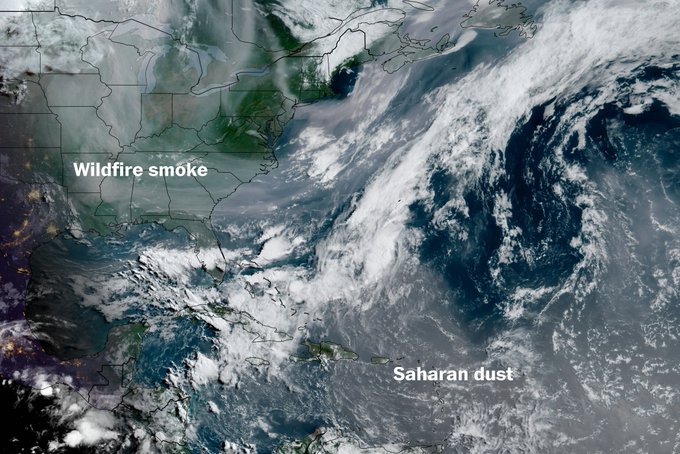
True. It was very hazy yesterday due to the smoke.
-

2025-2026 ENSO
michsnowfreak replied to 40/70 Benchmark's topic in Weather Forecasting and Discussion
Just a warning, some of us in the lakes forum have speculated that he is a former troll account. And same here; bluewaves theories, regardless of whether it is just to get the pattern correct, or its a convenient scapegoat to make nyc winters warmer/less snowy, or a mixture of both...would imply good winters here in MI so I would have NO issue with his outcome. I just dont like anyone talking in absolutes as if they have a crystal ball. While its very rare for NYC to have a better winter than here (tho it has happened- see 1957-58, 1960-61, 1995-96), it's a little more common for NYC to have a more favorable pattern for their local climate than we have for ours (even if the end result is still a "wintrier" winter here). So these assumptions that NYC is just never going to have a good winter barring a volcano eruption are imo ridiculous regardless of ANY background factors, let alone all of them. When it happens Ill be waiting patiently to hear the reasoning why it did. Especially from a snow perspective since this past winter was much, MUCH colder than anticipated, so the lack of east coast snowfall took the spotlight away from temps. If we ever DO have one of those years where its a good NYC winter and not a good one here, Ill be in a shitty mood, so I will REALLY wait for that explanation -
Haven't seen any aurora pictures from MN/WI/IL from last night so I'm guessing the smoke busted it?
- Today
-
Let's see how much (if any) that the Canadian wildfire smoke mitigates it - MU thinks it will have an impact.
-
2025-2026 ENSO
michsnowfreak replied to 40/70 Benchmark's topic in Weather Forecasting and Discussion
How were they? Hot, hot, hot lol. The 1930s-1950s were by far the era of most 90F+ days here. We had a spike again in the 2010s (but even then, far less 100s than the 1930s-50s) but have already digressed in the 2020s. Detroit has hit 100F+ a total of 38 times in 155 years of record, and 21 of those 38 times fell between 1930-1955. -
I know. Quite chilly for June
-
Another cool start, 48F at DTW and cooler elsewhere, but this time its warming up rapidly.
-
33.1 with heavy frost this morning. The car's windshield had an amazing amount of ice - pretty wild for June 2nd.
-
Had to turn my space heater on...this is kinda insane, lol Although a fb memory that came up for 2020 I was talking about how weird it was that it was still this cool!
-
My low was 3C/37F. The smoke plume has arrived over me looking at sat. With how dank this May was, at least I wasn't breathing in the smoke with that haze blocking out 25% of the sun. Not sure about these sunny days coming up.


.thumb.JPG.418e8a9a2902ae687ec35ff4bc0e038e.JPG)