All Activity
- Past hour
-

The “I bring the mojo” Jan 30-Feb 1 potential winter storm
Stebaney replied to lilj4425's topic in Southeastern States
When I look at the NES radar I see all of this precip coming towards us in triangle. Is this supposed to be heavy or just flurries? I have over 5” in 4 hours so I can’t imagine it being that heavy. -
Just missed having a supreme couple of winter weeks.... As is the last 10 days have been epic - Looking at these huge snow/sleet piles - If you just sobered up from a week long alcoholic binge you would think a 2 foot+ blizzard slammed the area... It may not have been 96 or 2016 but combined with the temps this glacier storm ranks as a top 10 for myself...
-

January 30th- Feb 1st ULL and coastal storm obs
knowledgeispwr replied to JoshM's topic in Southeastern States
Things are winding down here in SW Winston-Salem, only on and off light snow and flurries now. We're at about 8" of snow. A good storm! -

February 2026 Medium/ Long Range Discussion: Buckle Up!
GreyHat replied to Weather Will's topic in Mid Atlantic
ICON 0z positive and flat out front allows system go ots. NAM 0z not as positive and has heights rising in the Atlantic and allows system to come up north. Of course it's at the long range that isn't accurate. Wait for AI models.
-

The “I bring the mojo” Jan 30-Feb 1 potential winter storm
Kristospherein replied to lilj4425's topic in Southeastern States
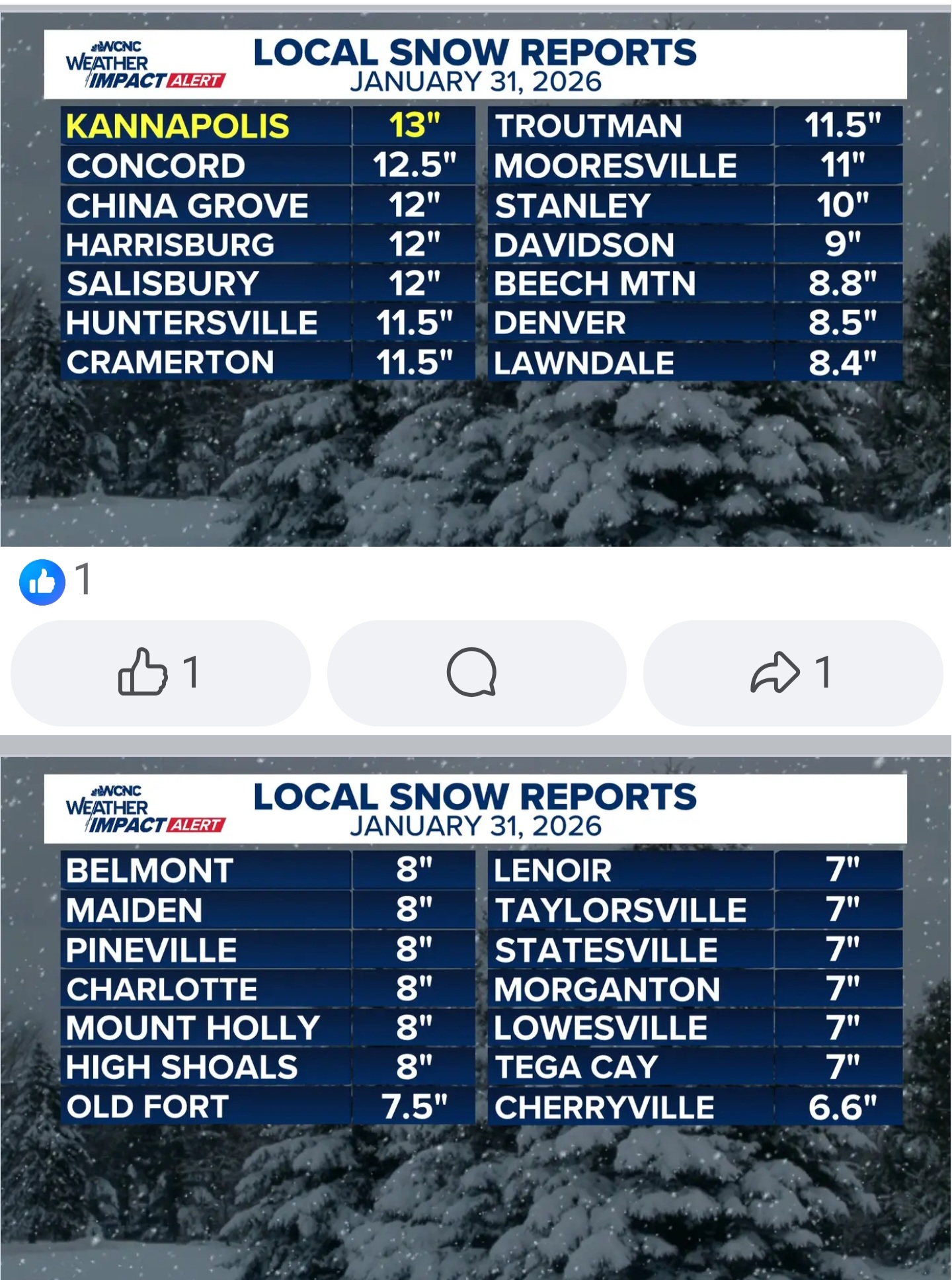
It was and appears inaccurate too. Here is what WCNC is reporting in and around Charlotte.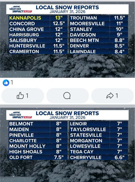
-
Ok, makes sense there. Not arguing that part. The part that doesn’t add up, is the thought(and not from you) that this is some how some sort of new regime, or idea. It is not. Kind of like the whole silly idea the past few years that clippers were a thing of the past. How come no more clippers? Where are the clippers? Well, now they’re back and in abundance once again. Whatever is causing the coastals to not get up here..or amplify close enough to the coast lately(forcing,flow etc etc), for SNE Will at some point change and that will be that. And I Appreciate your insight Ray on these ideas.
-
Dont agree with this.This is more or less some hybrid weather pattern this winter,plus while it can happen the atmospheric river into the west is more Nino than NINA,you cant possibly say the west has been dry this winter,California is over 300% in some parts of abnormal QPFS
-

Is we back? February discussion thread
40/70 Benchmark replied to mahk_webstah's topic in New England
I agree. -

The “I bring the mojo” Jan 30-Feb 1 potential winter storm
Orange county replied to lilj4425's topic in Southeastern States
No way we are at 2 in Garner But it is snowing -

Jan 30th-February 1st 2026 Arctic Blast/ULL Snow OBS Thread.
GBOVolz replied to John1122's topic in Tennessee Valley
Still got some flurries floating around . -
The “I bring the mojo” Jan 30-Feb 1 potential winter storm
Stebaney replied to lilj4425's topic in Southeastern States
I agree. We are over 5” now. -
Yeah! Thankful I got to experience the December 25th 2010 storm. Low formed in the gulf and went right up the coast. That’s how we get 12+ inches around here. I always keep in mind that norfolks biggest recorded storm was 18.5 inches in 1892. Reality check for when we see these crazy clown maps.
-
I have a freezer full.....
-

The “I bring the mojo” Jan 30-Feb 1 potential winter storm
sarcean replied to lilj4425's topic in Southeastern States
It's an hours old pic fwiw at this point and it dumped snow for a few hours after it -

January 30th- Feb 1st ULL and coastal storm obs
KrummWx replied to JoshM's topic in Southeastern States
im cold
-
The “I bring the mojo” Jan 30-Feb 1 potential winter storm
Aleksey replied to lilj4425's topic in Southeastern States
Yeah that map was older. I’m sure the updated one will fill in the entire state much more! . -

Possible coastal storm centered on Feb 1 2026.
Abbyme24 replied to Typhoon Tip's topic in New England
Yeah the Canadians look decent but Ukie is showing a bust for the southern half of the province including Halifax. Although looks like so far the system is west of what the globals have been predicting? Will be interesting to see what the short range models show in the morning. -
Yeah I am eating a little crow but I don't mind that
-
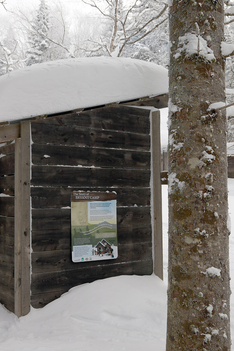
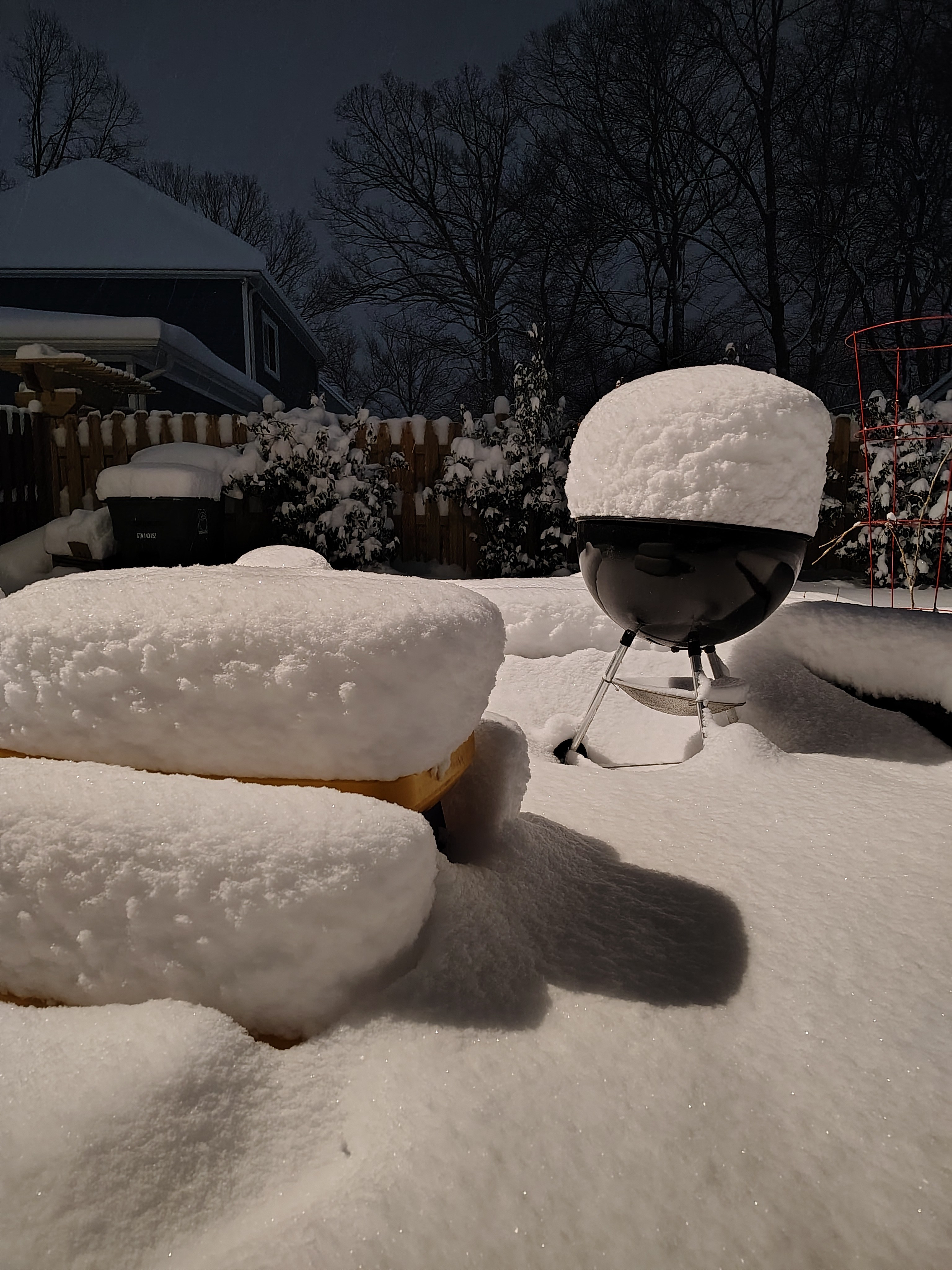
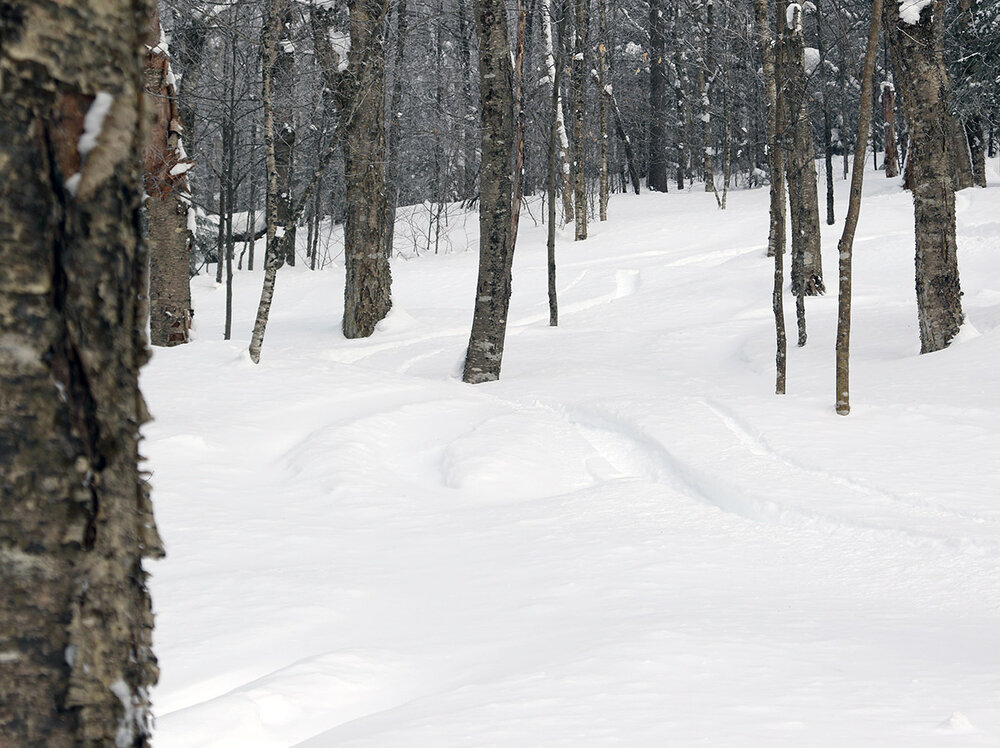
We had another cold January Saturday on our hands today, but temperatures were certainly up a notch from what we encountered last weekend. Instead of valley temperatures hovering around 0 F for highs, they were up around 10 F today, so I headed up to the mountain for a ski tour. The temperature was still only around 0 F when I arrived in the Bolton Valley Village around midday, and it was busy, but not “holiday weekend” type of busy, and I was able to get a parking spot right in the backcountry access lot. Thanks to Winter Storm Fern and the subsequent systems that have come through the area, we’ve had over two feet of new snow in the valley over the past week, and the Bolton Valley snow report was indicating 30 inches of snow at the resort in the past 7 days. The powder is still deep and plentiful, but the powder quality certainly isn’t up where it was right after Winter Storm Fern. That storm cycle concluded with a period of incredibly dry 1-3% H2O powder; that champagne was so incredibly light and dry that it skied like a dream on any sort of pitch. Powder of that airy nature would naturally settle rapidly on its own, and it’s easily been crushed by the snows of these more recent storms. The powder from this week’s smaller systems certainly wasn’t too dense, with snow densities in the 2-7% H2O range, but the tail end of our most recent one did finish off with some fine-grained flakes that came around 10% H2O. In combination with the powder settling on its own and under the new snow, I even encountered some areas of wind slab out there on my tour. All told, the combination of depth and density in the powder out there today couldn’t support good turns on low-angle terrain, so you had to hit mid-angle terrain or steeper. I toured up and around the Bryant Cabin today at elevations in the 2,000’ to 2,800’ range and settled powder depths were typically 14-15” on the low end, and 21-25” on the high end. So, I may be dissecting the finer points of the snow density, but there’s absolutely some fantastic powder out there. I initially descended through Gotham City and did a bit of exploring on new terrain, then I did another quick ascent to get a descent through Gotham in the Gun Sight area, which yielded some of the best turns of the day. There really hasn’t been a ton of traffic in many areas of the Nordic and Backcountry Network yet, so as long as you find those areas with appropriate pitches for the deep powder, you can get in some really nice turns. The resort looked like it was actually getting a little busier when I was leaving in the early to mid-afternoon period – the sun was coming out and the temperatures were climbing a bit, so that was the little extra nudge that people might have needed to get out for a few runs.

-
March 18 will find a way to happen again.
-

The “I bring the mojo” Jan 30-Feb 1 potential winter storm
Coach McGuirk replied to lilj4425's topic in Southeastern States
I measured 6 inches in December, A guy literally posted 5.5 inches a mile north of me and NWS Wakefield posted the map and we were 4 inches. -

January 30th- Feb 1st ULL and coastal storm obs
BornAgain13 replied to JoshM's topic in Southeastern States
8 1/4" Snow in Dry Fork. Still snowing but the heaviest is over i believe. What a Storm for so many! -
Possible coastal storm centered on Feb 1 2026.
Abbyme24 replied to Typhoon Tip's topic in New England
My wife is barely surviving NS winter, Newfoundland would break her -

Possible coastal storm centered on Feb 1 2026.
leo2000 replied to Typhoon Tip's topic in New England
The Canadian model runs today and the UkMet have been pretty good showing the storm closer to Nova Scotia. -

January 30th- Feb 1st ULL and coastal storm obs
olafminesaw replied to JoshM's topic in Southeastern States
9", should be about wrapped up