All Activity
- Past hour
-

Possible coastal storm centered on Feb 1 2026.
dendrite replied to Typhoon Tip's topic in New England
The ULL was a little slower and that trailing shortwave got a little more SE…maybe it feeling a bit of a “pull” last minute? I wish this s/w would just dive in sooner behind it.
-
Still not climbing as much as I want to get off the bottom.
-

2025-2026 Fall/Winter Mountain Thread
ncjoaquin replied to Buckethead's topic in Southeastern States
It's probably blasphemy to say that I would be thrilled with 7 inches and let the ENC fellows have the 24 inches that the GFS shows. There are too many problems that come with 2 feet of snow! I know I am a stranded loner on an island by myself with that opinion, lol! -

The Jan 31 Potential: Stormtracker Failure or 'Tracker Trouncing
Bob Chill replied to stormtracker's topic in Mid Atlantic
I'm thinking the gfs is overdoing it and our yards benefit somewhat from the northern stream closing off but not from the coastal CCB. Just a guess. Gun to head, 4-8 top end with 3-6 most likely. Will be high ratio snow on cold ground so we don't need a lot of qpf to have a nice event. -
With Monken we ride!!!!!
-

The Jan 31 Potential: Stormtracker Failure or 'Tracker Trouncing
Shad replied to stormtracker's topic in Mid Atlantic
Long ways still to go with this one but Id be shocked if this doesnt move North 100 miles in the next 48 hours.... -

The “I bring the mojo” Jan 30-Feb 1 potential winter storm
ADB83 replied to lilj4425's topic in Southeastern States
GFS really going to stick to their guns here. That is a very nice statewide win and here in Winston-Salem I would gladly take that snow and let the coast celebrate those big numbers. . -

The Jan 31 Potential: Stormtracker Failure or 'Tracker Trouncing
Ravens94 replied to stormtracker's topic in Mid Atlantic
1980. https://www.weather.gov/mhx/Mar011980EventReview#:~:text=On the afternoon and evening,eastern part of the state. -

The “I bring the mojo” Jan 30-Feb 1 potential winter storm
Buddy1987 replied to lilj4425's topic in Southeastern States
Do you feel like the models may be underestimating the precip shield or is it going to be more congealed, based around the baroclinity and then throwing it back? The wild card here is obv the ULL. Stronger that stays during it's trek of traversing better opportunity for folks further away from SLP forming off Hatteras. -

Possible coastal storm centered on Feb 1 2026.
CT Rain replied to Typhoon Tip's topic in New England
...for ACK. -

The Jan 31 Potential: Stormtracker Failure or 'Tracker Trouncing
dailylurker replied to stormtracker's topic in Mid Atlantic
I mean.. if it was over us I'd fully expect a 300 mile north jump. Happens all the time for southern NY. It looks like our storm and in the last 24 they go north. We can do that, right? RIGHT!? -

The “I bring the mojo” Jan 30-Feb 1 potential winter storm
StantonParkHoya replied to lilj4425's topic in Southeastern States
When are our players on the field? Today? -

1/30-1/31 Lake Effect Snow Threat - SE WI, NE IL, and NW IN
Chicago Storm replied to A-L-E-K's topic in Lakes/Ohio Valley
congrats southern cook and nw indiana? -
Minus a few ECMWF runs of this showing a blizzard , this was never our storm.
-

The Jan 31 Potential: Stormtracker Failure or 'Tracker Trouncing
Weather Will replied to stormtracker's topic in Mid Atlantic
WB 12Z GFS compared to 6Z basically a hold.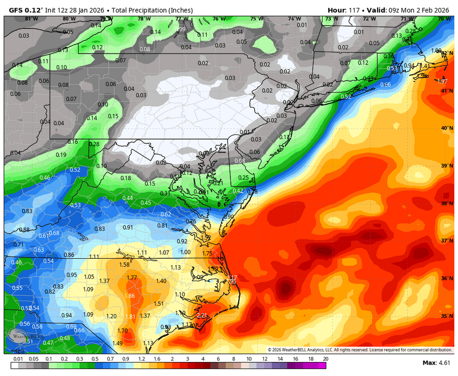
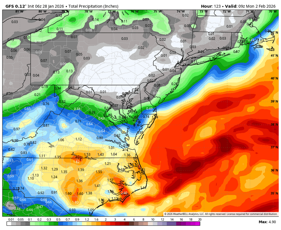
-
 Are the snow maps based on a 10 to 1 ratio?
 -

Possible coastal storm centered on Feb 1 2026.
EastonSN+ replied to Typhoon Tip's topic in New England
A miss would hurt due to what could have been. -

Possible coastal storm centered on Feb 1 2026.
40/70 Benchmark replied to Typhoon Tip's topic in New England
The only thing that has me bent over this month is the herniated disc I incurred from all of the shoveling....thanks, CC. -
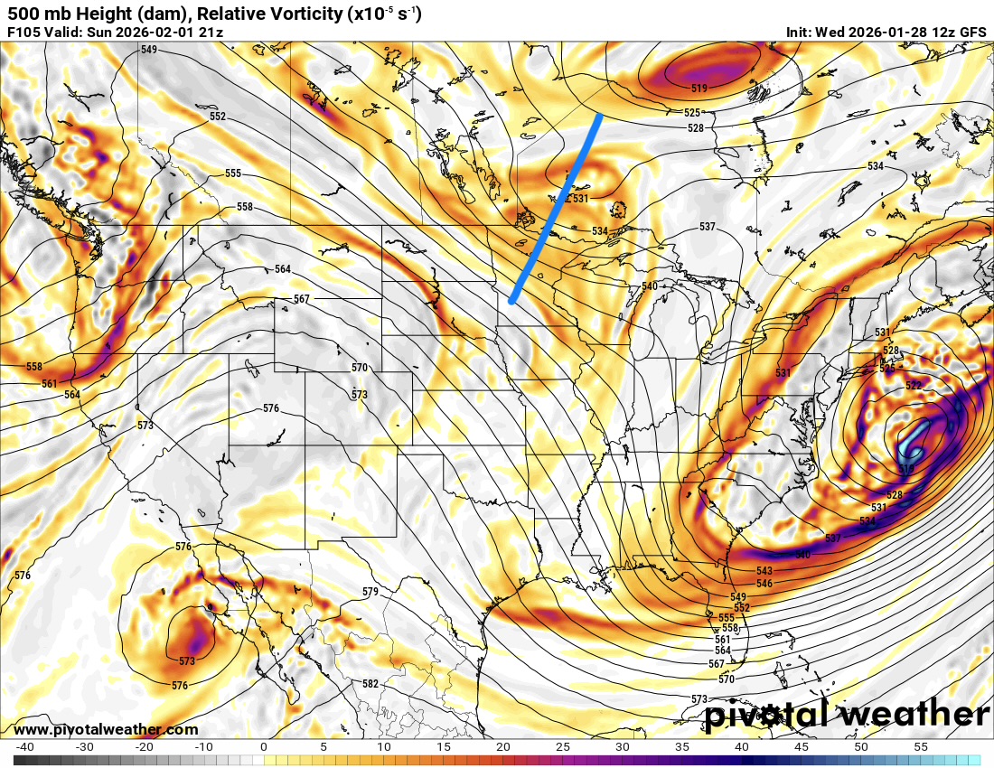
You can’t get a storm to turn the corner with a big positively tilted trough, especially when it starts that far South.
-

The Jan 31 Potential: Stormtracker Failure or 'Tracker Trouncing
clskinsfan replied to stormtracker's topic in Mid Atlantic
Is it possible to have a closed 500 on the GA/SC border and a surface low way out to sea like that? I would think as early as 500 closed off it would tug a surface low well west. Frustrating hobby man. -

Possible coastal storm centered on Feb 1 2026.
weathafella replied to Typhoon Tip's topic in New England
That would be harder looking out at 2 feet. -

The “I bring the mojo” Jan 30-Feb 1 potential winter storm
NorthHillsWx replied to lilj4425's topic in Southeastern States
Fundamentally not much at all has changed across modeling. I think we’re now honing in on the specifics of where the coastal cranks, and a possible interaction with multiple areas of SLP. Trough digging and going neutral to negative captures the southern stream energy (textbook) pulling everything to coast wrapping up a bomb like GFS is insisting. I’m at a loss for how perfect that run was -

The Jan 31 Potential: Stormtracker Failure or 'Tracker Trouncing
DJnVa replied to stormtracker's topic in Mid Atlantic
Well that's just mean. US SEVA folks want some snow too. -

Possible coastal storm centered on Feb 1 2026.
Damage In Tolland replied to Typhoon Tip's topic in New England
Here it comes -
There was a bit more precip on the NW side but it was a setup back in the upper levels.