All Activity
- Past hour
-
was going to areate this morning. Can't do that in puddles. had to move the reservation to tomorrow :-)
-
Last winter the storm track was even suppressed south of me in extreme NW NC. Thankfully we always get consistent upslope snow so we still ended up with 43.5 inches but very little was from larger synoptic events even this far south.
-
This band is cookin” right now
-
Overperformer here. I underestimated how well our windward side areas can do with an Atlantic coastal.
-
WOW! What luck.. 2.34 inches of rain over the last 24 hours! Very unexpected amounts here in my backyard!
-
.91" yesterday, and another .11" already today.
-
Biggest drought monitor of our lives?
-

2025 Atlantic Hurricane Season
NorthHillsWx replied to BarryStantonGBP's topic in Tropical Headquarters
I keep hearing about comparisons to last year’s slow start to September and while there are similarities with SAL and wave breaking, this one is simply much slower. At this point in September last year we had a cat 2 (landfall in Louisiana) and a TS. We haven’t even had a named storm yet, though that might change by tomorrow. Looking further into seasons comparison, 2024 was WAY more active to this point. Yes system numbers are similar, but at this point last year, we had had 4 hurricanes including a devastating cat 5, a US cat 2 landfall, and a very impactful cat 2 landfall on Bermuda plus Debby, a cat 1 that hit Florida. We have legitimately a 1 storm season this year. Erin was a named storm for 11 days. If you add up the rest of this years systems, you don’t even get 11 days combined from the other 5 systems. Heck 3 of them were only named for a day or less. The inactivity of the entire basin is simply stunning. We are now at 1/2 of our average ACE and that is including a 30+ unit ACE storm! I could go on and on but the point is, this is not like 2024 besides both shared an extended dead period mid season. The difference is 2025 wasn’t active before the dead period. 1 storm does not make the basin “active”. While I am sure future threats will materialize in the gulf and climo favored areas, I am simply shocked by how dead the Atlantic and entire northern hemisphere has been. -
They really need to change their opposition to air conditioning since Europe has some of the fastest summer warming on the planet. https://www.cnn.com/2025/07/02/climate/europe-air-conditioning-heat-wave-intl-latam
-
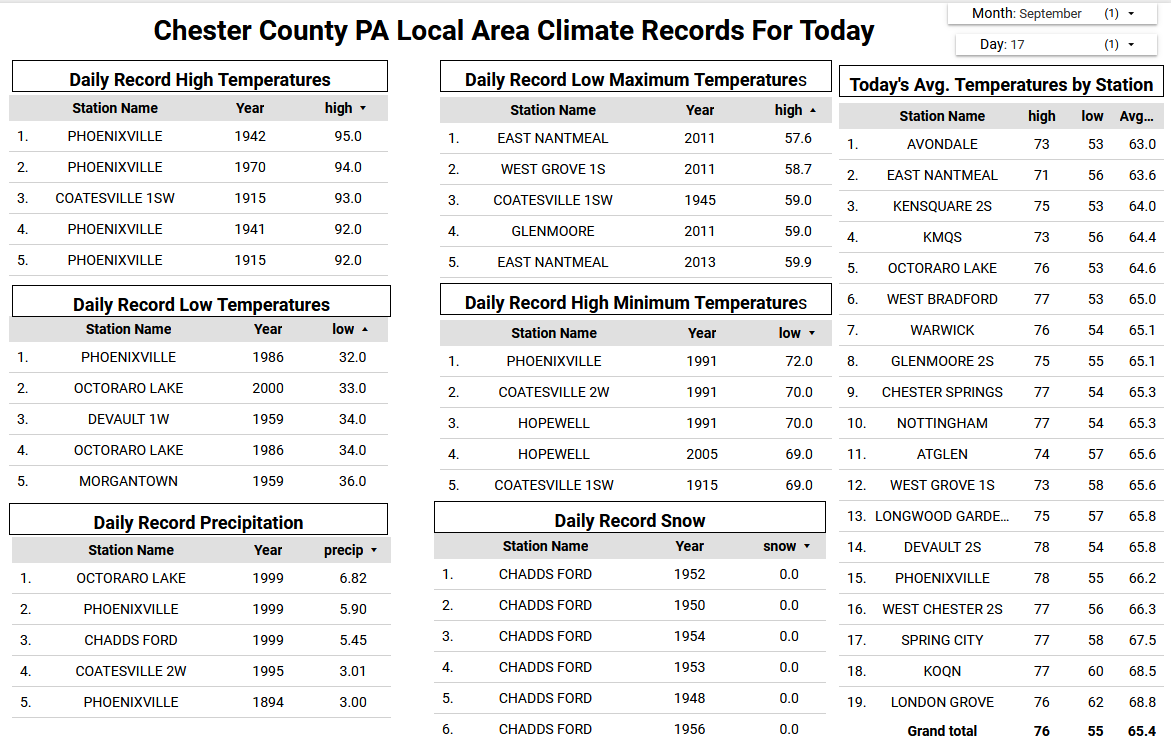
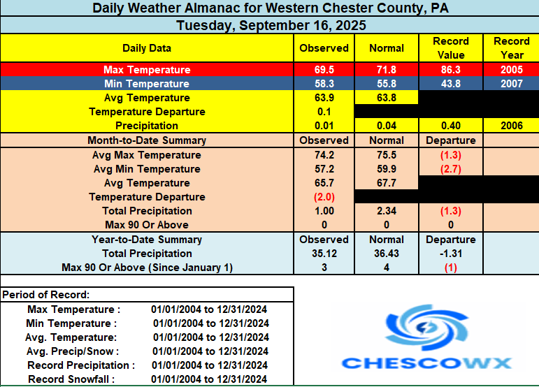
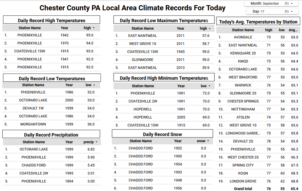
Most spots have picked up at least a little rain since last night. The most I can find is the 0.27" down south in Nottingham with the least at Chester Springs with 0.01". Today we should see a continuing chance of some showers but again with the greatest amounts across Southern Chester County and down into Maryland. We stay in the chilly 60's with the ocean flow continuing through today. We start a brief warm up with both Thursday and Friday reaching near 80 degrees especially across the valley locations. We turn much chillier by Friday night and could again see some 40's for low temperatures across the typically chilly valley locations by Sunday morning. High temperatures in the lower 70's. Of note today is the date of the earliest freeze in recorded Chester County weather history when we reached 32 degrees at Phoenixville in 1986.
-
(002).thumb.png.6e3d9d46bca5fe41aab7a74871dd8af8.png)
E PA/NJ/DE Autumn 2025 Obs/Discussion
ChescoWx replied to PhiEaglesfan712's topic in Philadelphia Region
Most spots have picked up at least a little rain since last night. The most I can find is the 0.27" down south in Nottingham with the least at Chester Springs with 0.01". Today we should see a continuing chance of some showers but again with the greatest amounts across Southern Chester County and down into Maryland. We stay in the chilly 60's with the ocean flow continuing through today. We start a brief warm up with both Thursday and Friday reaching near 80 degrees especially across the valley locations. We turn much chillier by Friday night and could again see some 40's for low temperatures across the typically chilly valley locations by Sunday morning. High temperatures in the lower 70's. Of note today is the date of the earliest freeze in recorded Chester County weather history when we reached 32 degrees at Phoenixville in 1986.
-
So jealous dude. Not only a beautiful part of the world, but they do winter right. My extended family down the road in Tupper just get nailed from early November into mid April.
-
0.56 overnight... light rain still falling with that rain band from the NE 0.92 since August 1st.
-

September 2025 OBS-Discussion centered NYC subforum
Picard replied to wdrag's topic in New York City Metro
Don, I'm curious where you pull your data? Is it accessible to anyone? If it's intuitive enough, I want to play around with the numbers some more for my area. Thx. -
.52. Much needed rain!!!!
-
Yeah, it’s funny that most of the seasonal model forecasts for this winter are defaulting to figure 1 full trend.
-
Patiently waiting
-

September 2025 OBS-Discussion centered NYC subforum
SACRUS replied to wdrag's topic in New York City Metro
66 / 58 cloudy. Offshore cut off ULL spins around. NNE/NE flow today, steadiest and heaviest rains in SNJ and staying focused there with light / scattered showers , rain - drizzle north as the systems pulls sway. Clearing out and warming up Thu/ Fri ahead of a front Friday evening (dry). Cooler but dry / nice weekend. Overall warmer from Monday and beyond. Another low under the ridge cuts off next week to our west but the next chance of rain later next week, overall warm. 9/17 - 9/18 : clouds - showers , breezy - clears 9/18 9/18- 9/19: Warm up 80s (warmest spots to mid/upper 80s on Friday ahead of front 9/20 - 21 : Cooler / but dry weekend 9/21 - Beyond : Warmer overll cut off low may come east by the 25th with next rain chances otherwise dry -
East, SE, NE are a good trajectory for your area. Upslope instead of downslope.
-

2025-2026 ENSO
donsutherland1 replied to 40/70 Benchmark's topic in Weather Forecasting and Discussion
He's done invaluable work. I share your sentiments. -
First time I've seen wet ground in over a month. And it's pretty rare here to see rain rotate in from the NE.
-
Wrong side of the 'haves/have nots' here this time. Would have hurt more if it was 25 degrees in Feb. A few sprinkles around 3 pm and again around dusk. Not even enough to dampen objects. Currently 57.3/55.3.
-
definitelyt making up for the 14 wet wknds in a row
-
Wait for real?
- Today
-
Yawn