All Activity
- Past hour
-

Possible coastal storm centered on Feb 1 2026.
Typhoon Tip replied to Typhoon Tip's topic in New England
WPC's caught on -
Globals always struggle with mix lines. They excel at qpf but ptype is often more muddy. This is where forecasters earn there money. Applying historical/past experience and the region's favored climo outcomes can often make sense of this and produce a solid forecast that doesn't mirror any specific weather model output. Hobbiests should do the same. I agree, it was obvious based on soundings and mid level temp panels that the zr threat was overdone the euro. Easy mental adjustment. Models aren't perfect and rarely nail a forecast top to bottom. The nam 3k is unpredictable and inconsistent with qpf output but it's pretty good with thermals. Apply that skill to the euros qpf output and see what happens to your expectations. Snow maps and snow output is an algorithmic map and also a new phenomenon. They didn't exist when I joined Eastern wx and they have always been unreliable. They are a good snapshot/data point tool but without applying critical thought they should never be used verbatim as an expectation. In the past we used to (as a group) decide how much qpf will likely fall as snow and create our own estimates. I still do this and will continue. Snow maps are fun to look at but make terrible wives. Don't marry them. Use your brain. If you are using the ensemble snow maps at short range and setting expectations then you will often not be correct. Euro AI ens are great upper air tools in the mid range and seem pretty good at qpf in the mid range but when you're inside of 48-72 hours, op runs are the heavyweights by a large margin.
-
I’m very happy you showed the Hazards Forecast for the CONUS as it’s a pretty good product for stakeholders to utilize in order to look out for potential weather hazards in the medium range for decision making purposes. However, just to correct, and only doing this because it’s my office that does it, this is a WPC product, not SPC. SPC is a different office that specializes in severe and fire weather with mesoscale discussions for winter weather created as well. Just an FYI, we are different
-

January 2026 Medium/Long Range Discussion
NorthArlington101 replied to snowfan's topic in Mid Atlantic
Eh - I think it’s pretty clear where the favored spots are for something like this and that’s all this shows. Maybe we are saying the same thing but I don’t take this as a massive negative. I don’t think there’s enough confidence to have anywhere but the spots that jut into the Atlantic yet… doesn’t mean we’d be out of the game at all. -
Took me a while this morning, my side of street is where all the snow goes. Shoveled when the snow changed to sleet, this morning when I woke up I had like 2-4” on my sidewalk of just crust I could walk across without sinking in .
-

The “I bring the mojo” Jan 30-Feb 1 potential winter storm
Orange county replied to lilj4425's topic in Southeastern States
And this is why the next week or ten days would be nice................ -
Let's just stomp this idea out right now. This is not going to cut. The closest we would get is a coastal runner, and that's going to be a dry(er) solution for most - and is not likely with a 530 DAM isobar over Kentucky. No.
-
 That 13 is right on me and I have 19
 -
it's well known the only reason Ji is still here is because he has pics of the mods in bed with the JMA
-
.thumb.png.4150b06c63a21f61052e47a612bf1818.png) Big dendrites here with moderate snow. half inch new the past hour.
Big dendrites here with moderate snow. half inch new the past hour. -
 Practically zero moisture. Probably wont groom real well. Id like to ride local this wknd but not sure how well trails will be. Sent from my SM-S921U using Tapatalk
 -
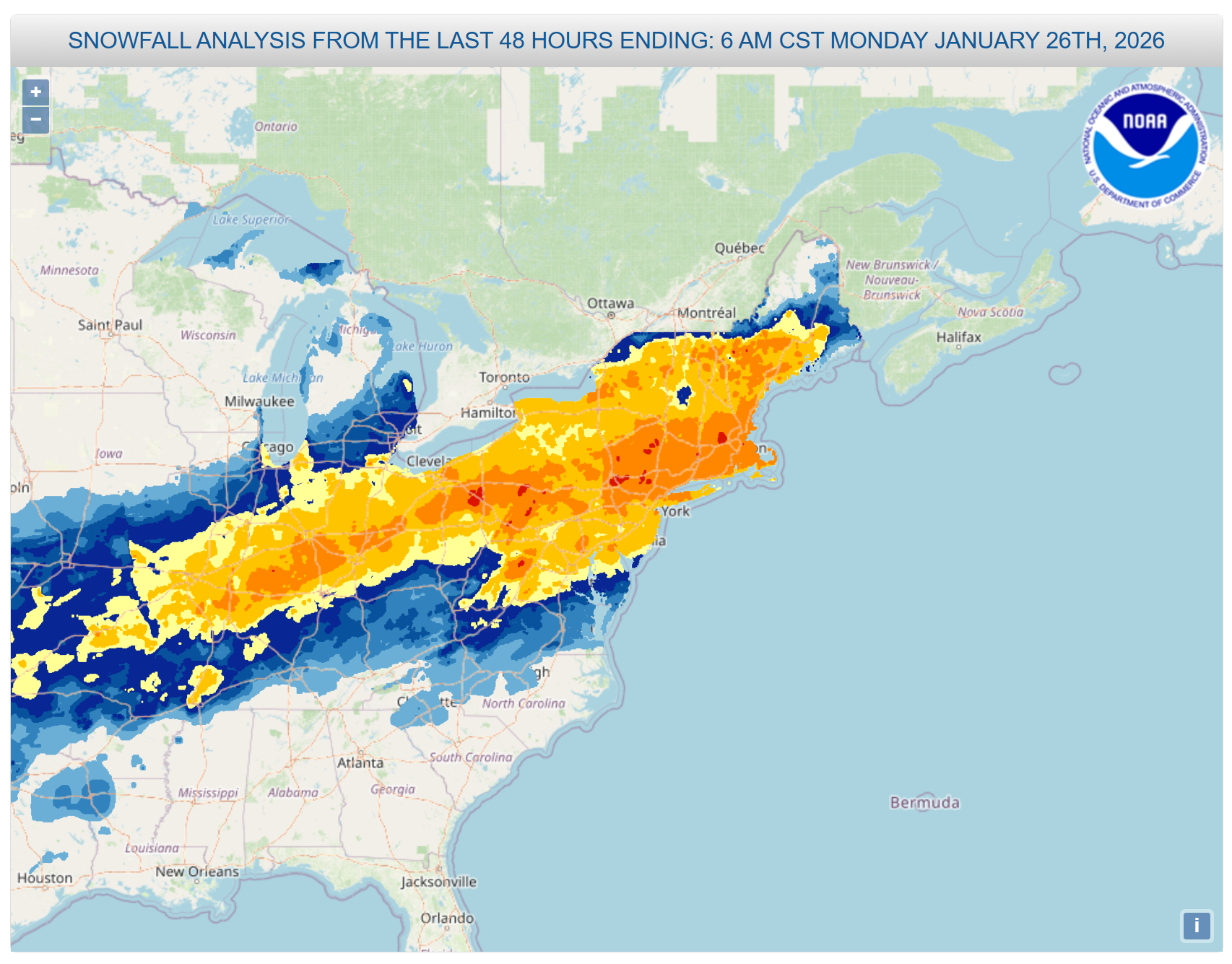
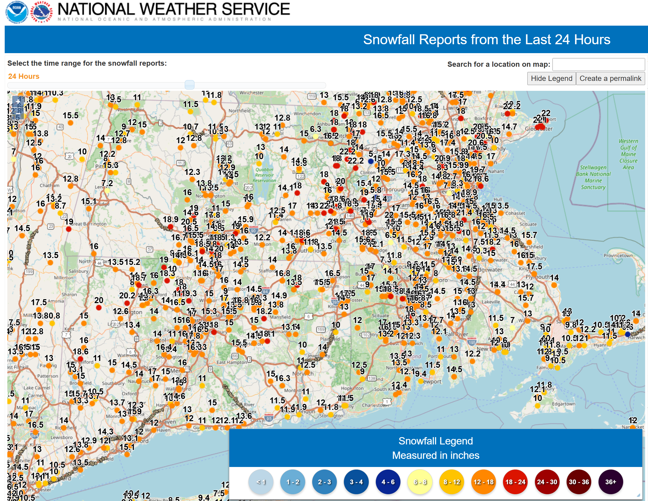
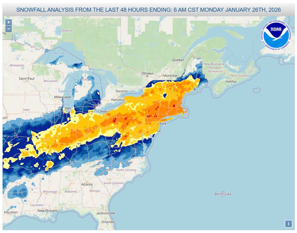
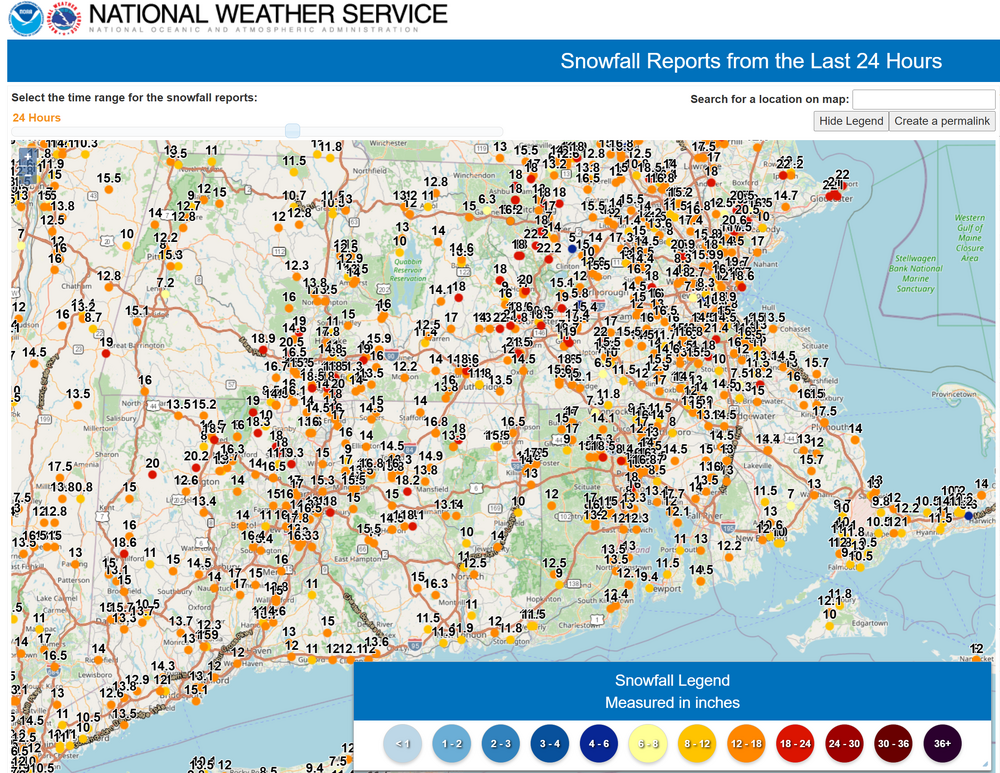
I hope this ok, i know there is an obs thread for this but it's 72 pages so far and reports get lost in the sea of posts. This is a major KU, so i wanted a place for people to put their final storm totals for the event. NYC did this and i thought it was a good idea. It will be super helpful for me as well when constructing a final map for SNE. North Haven, CT - 14.1" Seymour, CT - 16.0" Bethany, CT - 16.5" Snowfall Reporting Resources NWS BOX PNS NWS OKX PNS NWS ALY PNS NWS 72-Hour Interactive Map NWS 72-Hour Snowfall Total Analysis CoCoRaHS daily reports CoCoRaHS Interactive Map Cocorahs/COOP/Climo Reports
-
I fully trust that DCA has accurate and reliable snow measurements. What I disagree with is the notion that DCA is in any way representative of the region when it comes to snowfall. It is a zero elevation warm spot on a river and in the midst of the DC heat island. That’s why their snow totals are what they are.
-

The “I bring the mojo” Jan 30-Feb 1 potential winter storm
Upstate Tiger replied to lilj4425's topic in Southeastern States
And unlike 1980, the preceding days will not be mild. -
 Dang
Dang -
This says a lot about where they really think the storm track is going to be.
-

-
 Ok...Im right on the Springfield/Longmeadow line, the kid measured 14 out in the open in an unplowed section of road. There was three already otg before the storm started on many grassy surfaces...just seems a little high but Springfield is huge. We also had terrible snowgrowth and there's some serious meat in this arctic sand so I have no doubt believing we got 1.4 inches qpf.
 -

1/24-1/25 Major Winter Storm - S. IL, IN, and OH
Torchageddon replied to A-L-E-K's topic in Lakes/Ohio Valley
Thank you for all the details, much appreciated! -
This is crap about any micro climate warming DCA or decreasing snowfall during a raging snow and sleet storm . Let’s see if you do know something. Give me initials of the last mic at DCA. I can tell you he told me that it’s an FAA facility not a NWS one so they don’t exit the facility to do any measuring. The use a melt down device from outside the office and apply the ratio they believe us accurate
-
That’s what the J actually stands for
-
Ji is slacking .
-

The “I bring the mojo” Jan 30-Feb 1 potential winter storm
StantonParkHoya replied to lilj4425's topic in Southeastern States
March 1st is also a tricky time to snow in the South. Yes it can, but the sun angle is STRONG by then so any BL problems are amplified. Not as much the case late Jan. -

January 2026 Medium/Long Range Discussion
IUsedToHateCold replied to snowfan's topic in Mid Atlantic
This is in their example - so they use GFS data. from earth2studio.data import GFS -
Oh hell yes