All Activity
- Past hour
-
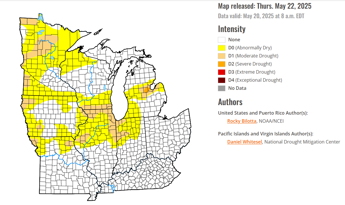
Through 5 pm, Bridgeport, Islip, New York City-Central Park, New York City-LaGuardia Airport, and Newark are in line to set new record low maximum temperatures for May 22. JFK Airport is in line to tie its record. After an unseasonably cool start, temperatures will top out in upper 50s and lower 60s tomorrow in the New York City area. There could also be some scattered showers. A partly to mostly sunny Memorial Day weekend will then follow. The below normal temperatures could persist into early next week. However,it could turn noticeably warmer during the closing days of the month or opening of June. The ENSO Region 1+2 anomaly was 0.0°C and the Region 3.4 anomaly was +0.1°C for the week centered around May 7. For the past six weeks, the ENSO Region 1+2 anomaly has averaged +0.55°C and the ENSO Region 3.4 anomaly has averaged -0.07°C. Neutral ENSO conditions will likely continue through at least mid summer. Early indications are that summer 2025 will be warmer than normal in the New York City and Philadelphia areas. The potential exists for a much warmer than normal summer (more than 1° above normal). The SOI was -8.71 today. The preliminary Arctic Oscillation (AO) was +0.091 today. Based on sensitivity analysis applied to the latest guidance, there is an implied near 62% probability that New York City will have a cooler than normal May (1991-2020 normal). May will likely finish with a mean temperature near 63.0° (0.2° below normal).
-
Drove thru a brief torrential downpour on 70 west. There’s some meat to the clouds today
-
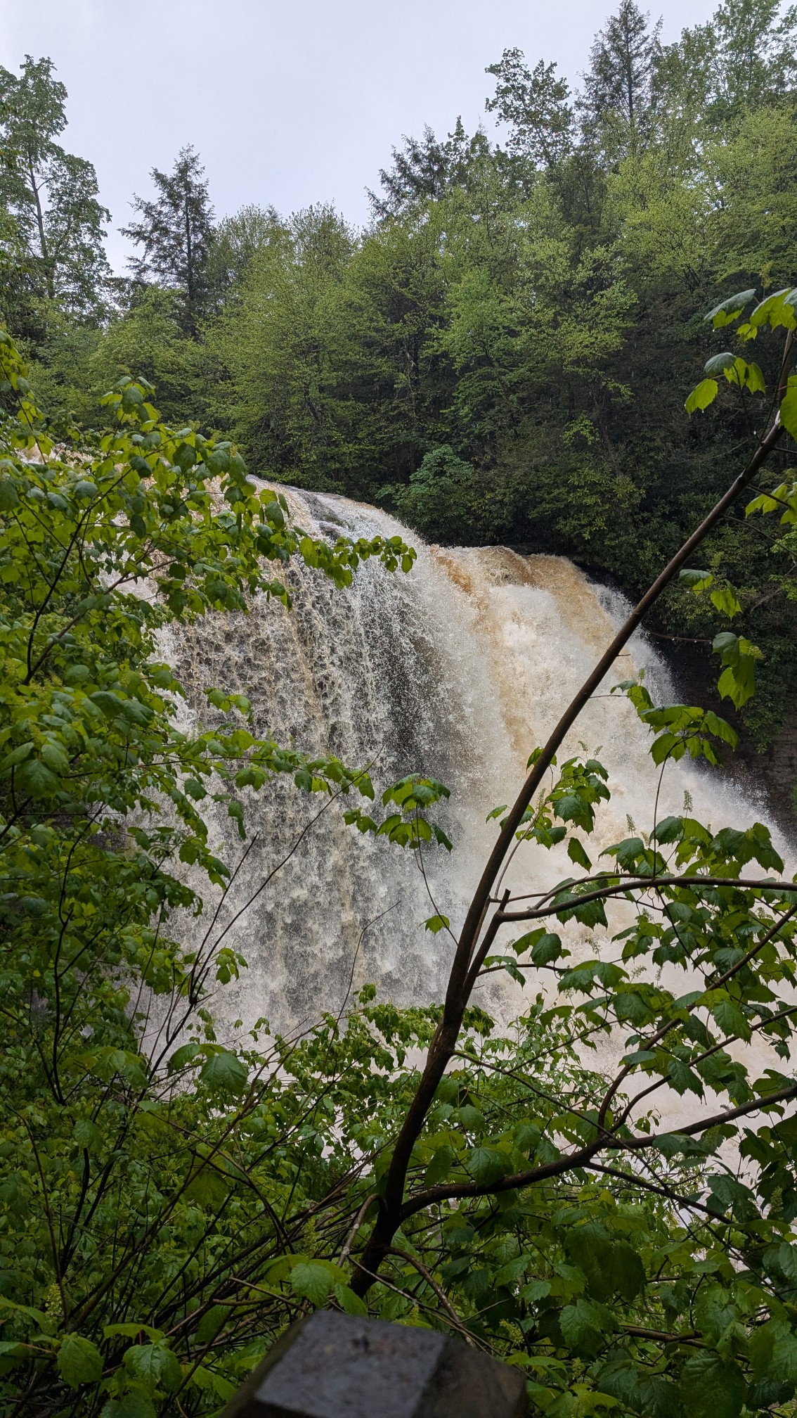
Some legit downpours in these showers.
-
NAMS and EURO too far west yet again....we only got about .65 here
-
Fucking oak dongs clogged my gutters.
-
I game her options to warm herself up. I got the cold shoulder.
-
Maybe 40 now. Love a good coastal.
-
It is absolutely pouring and about 35+ now.
-
-
I think a little over 1k? Maybe it’s just big drops reflecting the light. 37-38 in that area now.
-
Ope.

-
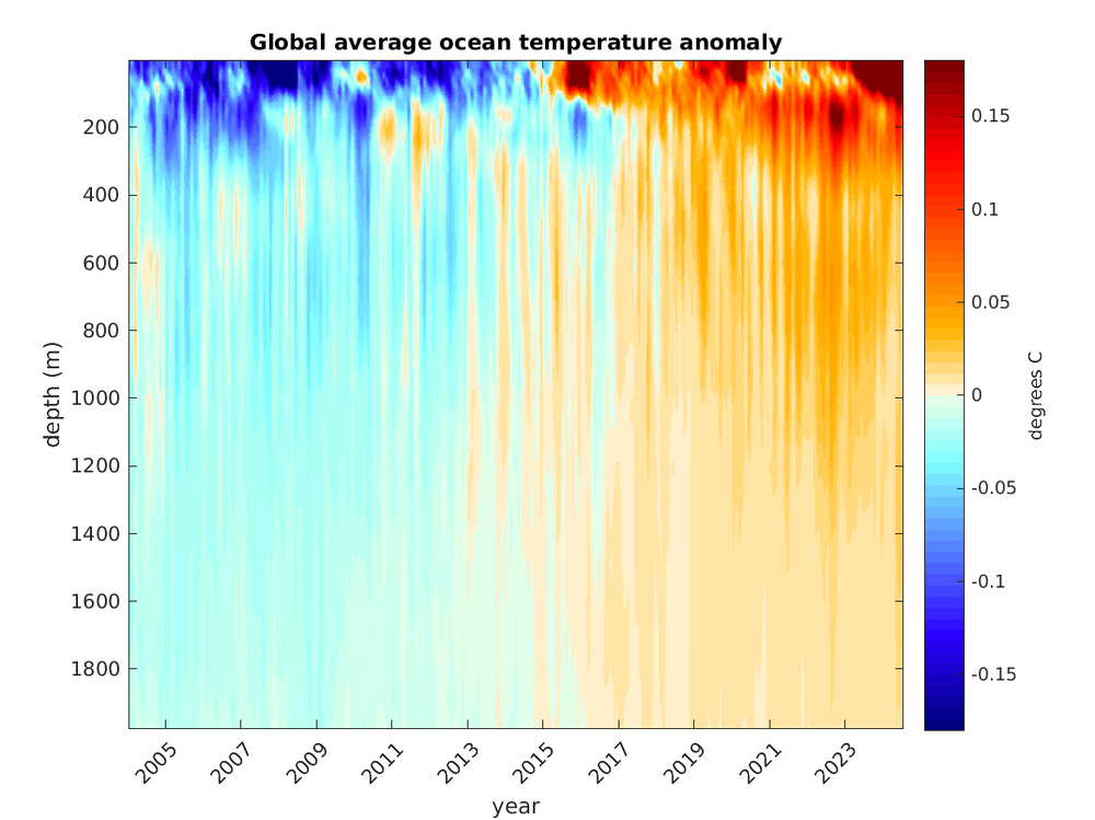
Not sure how anyone could come to that conclusion since this is a top down ocean warming process. https://www2.whoi.edu/site/argo/impacts/warming-ocean/
-
Definitely possible on top of the pocono plateau. Elevations over 2,000’. It’s been snowing and accumulating all day on top of the southern greens in Vermont.
-

2025 Spring/Summer Mountain Thread
Met1985 replied to Maggie Valley Steve's topic in Southeastern States
Yeah the wind has really picked up here this afternoon in Hendersonville. -
wind train in my hood
-
Pouring and blowing about 30ish now. Nearing 1".
-
What their ele?
-
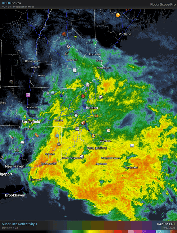
Just absolutely pouring rain right now.
-
-
Miserable day at DCL. Gusty winds to 30mph and constant drizzle, rain at 48F. Went to cranesville swamp and swallow falls and had both places entirely to ourselves. Thank goodness for gore-tex.

-
I was expecting thunderstorms today, but I did not think we’d get a warning in the local area.
-

2025-2026 ENSO
michsnowfreak replied to 40/70 Benchmark's topic in Weather Forecasting and Discussion
Just hearing a POSSIBILITY of 2013-14 is orgasmic. A weak knock off would still be a fantastic winter. - Today
-
Def looks like something now.
-
The warm spots topped out in the upper 80s. This delayed first 90° could mean that the warm spots like Newark could avoid a top tier summer for 90° days. The only season following a May with no 90° days to reach 40 days of 90° highs was 1983. But that was a super El Niño and this is a La Niña. If Newark can go on to avoid a very high 90° day count over 40 days, then it would probably mean a very wet and humid summer for us. Since Newark needs a dry summer for a very high number of 90° days. Data for January 1, 2025 through May 22, 2025 Click column heading to sort ascending, click again to sort descending. OCEAN COUNTY AIRPORT WBAN 89 NEWARK LIBERTY INTL AP WBAN 88 HARRISON COOP 88 Newark Area ThreadEx 88 TETERBORO AIRPORT WBAN 87 ESTELL MANOR COOP 87 TETERBORO AIRPORT COOP 87 ATLANTIC CITY INTL AP WBAN 86 LONG BRANCH-OAKHURST COOP 86 HIGHTSTOWN 2 W COOP 86 NEW BRUNSWICK 3 SE COOP 86 CALDWELL ESSEX COUNTY AP WBAN 86 BELMAR FARMINGDALE ALLAIRE AP WBAN 86 SOMERSET AIRPORT WBAN 86 All years at Newark with no 90° days in May Monthly Number of Days Max Temperature >= 90 for NEWARK LIBERTY INTL AP, NJ Click column heading to sort ascending, click again to sort descending. 2025 0 0 M M M M M 0 2020 0 0 5 17 9 0 0 31 2014 0 0 2 8 2 3 0 15 2009 3 0 0 1 10 0 0 14 2008 0 0 6 11 2 3 0 22 2005 0 0 10 11 12 4 0 37 2003 0 0 5 8 7 0 0 20 1997 0 0 7 10 3 0 0 20 1990 2 0 5 9 9 1 0 26 1989 0 0 4 12 8 3 0 27 1984 0 0 8 6 8 0 0 22 1983 0 0 7 15 11 7 0 40 1982 0 0 1 10 1 0 0 12 1976 2 0 7 2 4 0 0 15 1973 0 0 5 9 12 5 0 31 1972 0 0 0 16 4 1 0 21 1971 0 0 6 7 7 2 0 22 1968 0 0 4 9 9 1 0 23 1967 0 0 5 1 1 0 0 7 1966 0 0 10 14 8 1 0 33 1963 0 0 6 11 3 0 0 20 1961 0 0 4 13 8 9 0 34 1960 1 0 3 2 8 1 0 15 1958 0 0 2 11 6 2 0 21 1954 0 0 5 10 3 0 0 18 1952 0 0 8 17 2 4 0 31 1950 0 0 8 6 3 1 0 18 1946 0 0 5 5 2 0 0 12 1940 0 0 2 11 1 1 0 15 1938 0 0 4 4 9 0 1 18 1935 0 0 1 11 2 0 0 14
-
88 has been the high in the warmest spots