All Activity
- Past hour
-
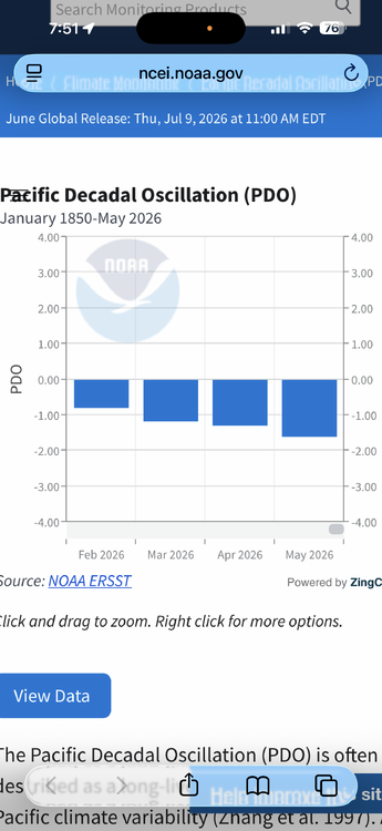
PDO trending in the wrong direction at this time.
-

2026-2027 Super El Nino
Stormchaserchuck1 replied to Stormchaserchuck1's topic in Weather Forecasting and Discussion
It worked last December. -

Junorch obs and discussion 2026
Damage In Tolland replied to Damage In Tolland's topic in New England
We’ve needed and run AC 8-10 days/ nights since that Napril furnaced 4 days that kicked off summer -
fun times ahead? @weatherwiz
-
not bad... .48 on the day and .41 from this afternoon storm.
-
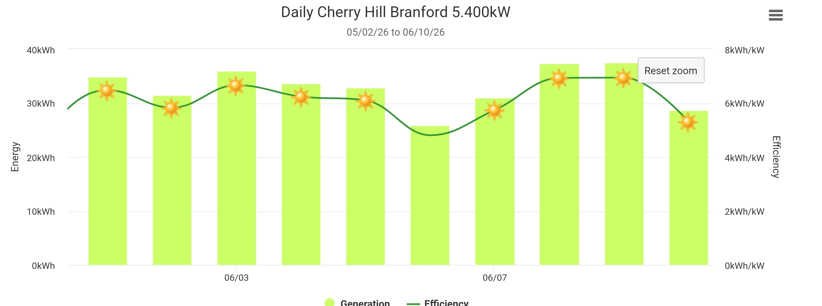
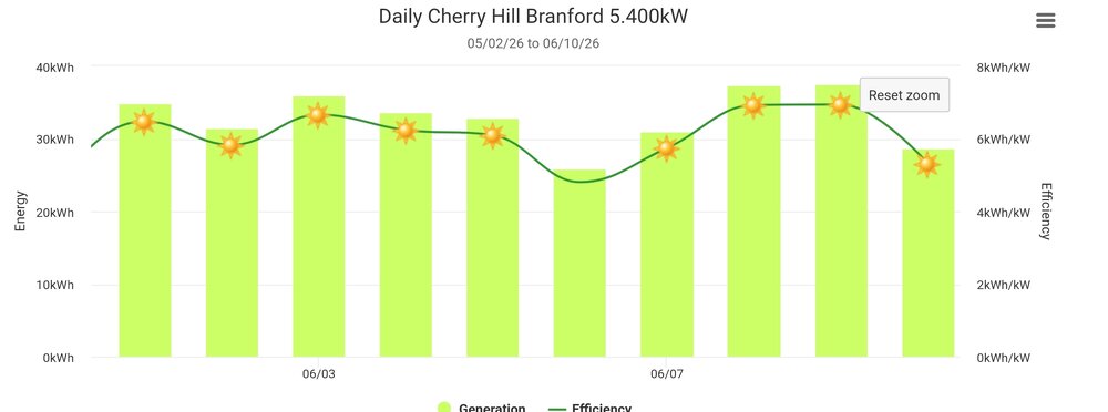
Yeah. I lived in the Burlington area back in the early 2000s and was blown away how cloudy it was up there. Its been like 10 straight days of sun here on the CT shoreline. My solar panels have been absolutely cranking in production efficiency.
-
This thing moved in very quickly. Temps dropped into the 60s here, so this thing is probably developing a cold pool. Had a nice burst of 50mph winds and continuous lightning.
-
A period of above normal temperatures is developing. The temperature will likely top out in the upper 80s to lower 90s tomorrow through Saturday. Parts of the region could experience a heatwave during the second half of the week. Humidity levels could make the heat particularly uncomfortable. In addition, strong to severe thunderstorms could develop tomorrow and again on Friday. Sunday will remain very warm with highs mainly in the upper 80s. Cooler weather will return for at least the first half of next week. Some rain is also likely early next week, but rainfall amounts could be fairly light. The ENSO Region 1+2 anomaly was +2.6°C and the Region 3.4 anomaly was +1.3°C for the week centered around June 3. For the past six weeks, the ENSO Region 1+2 anomaly has averaged +1.95°C and the ENSO Region 3.4 anomaly has averaged +0.98°C. The ongoing El Niño will continue to strengthen through the summer. The SOI was -5.69 today. The preliminary Arctic Oscillation (AO) was +0.630 today. Based on sensitivity analysis applied to the latest guidance, there is an implied near 80% probability that New York City will have a warmer than normal June (1991-2020 normal). June will likely finish with a mean temperature near 74.9 (2.9° above normal). That would make June 2026 the fifth warmest June on record. Supplemental Information: The projected mean would be 3.5° above the 1981-2010 normal monthly value.
-
I am watering my front lawn, it just seems rain falls apart in the spring and summer as it moves east across NYC toward Long Island.
-
Just over an inch of welcome rain this afternoon. Good thing I heavily watered the garden this morning lol.
-
High was 81 here today. Down to 71 now. No need to install yet.
-
it's a magical thing.
-
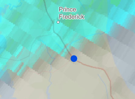
I finally got to see a thunderstorm with some good lightning while visiting my parents in northern Calvert. Prince Frederick got a flush hit with the Mesonet station there recording 1.19 but my place (blue dot) was just outside of it. So close though!
-
79° / 69° the breeze feels nice. Going to give it another night without an install. Window fan should suffice.
-
How we feeling about things out west chicago gang
-
Do the CAMS have the complex developing from the current severe outbreak over N Missouri? If that complex stays far enough south and weakens there should be a return flow behind it. If it expands north overnight and rains all over the place instability will be trashed.
-
Reverse jinx worked here too. Thanks @Chicago Storm!
-
Missed a bunch of overnight rainfall on the obs. We’ve had 0.57” today
-
Dry gust front hopped over MBY then cells filled in to the east while original line fell apart. Rain screwed.
-

Central PA Summer 2026 Discussion/Obs Thread
AccuChris replied to Voyager's topic in Upstate New York/Pennsylvania
Picked up 1.20” of rain in Lebanon from the cells before with pretty gusty winds…true gully washer here before . -

E PA/NJ/DE Summer 2026 Obs/Discussion
Birds~69 replied to PhiEaglesfan712's topic in Philadelphia Region
Underwhelming...lights flickering was the highlight. -

Central PA Summer 2026 Discussion/Obs Thread
canderson replied to Voyager's topic in Upstate New York/Pennsylvania
Heat advisories issued for Thursday and Friday. Picked up .85” rain today. Glorious desperately needed rain. -
Fog lifted for a couple hrs this morning, and the sun came out jacking temps into the upper 60's, then the fog returned with temps in the low 50's. Fog has lifted this evening with some showers moving thru. It'll be back tonight.
-
18z GFS