All Activity
- Past hour
-
It rained here all night... mostly light to moderate, but with a few downpours mixed in. My total is up to 2.30".
-
We hit 42 in Somerset this morning. Felt very fall like with the breeze too. Perfect afternoon weather though
-

E PA/NJ/DE Spring 2025 Obs/Discussion
ChescoWx replied to PhiEaglesfan712's topic in Philadelphia Region
One nice last day today before we see a wet and unseasonably chilly few days as we head toward the Memorial Day Weekend. Today's high temperatures will be around 5 degrees below normal but by tomorrow we could be more than 20 degrees below seasonable levels for late May with temperatures staying in the low 50's. The rain begins just after rush hour tomorrow morning and many areas will see at least an inch of rain by Thursday night. Most places with this next rain event will move to above normal rainfall for the year to date. We can see some showers continuing at times both Friday and Saturday but generally a drying trend. We finally see the sun back by Sunday with temperatures while warmer still well below normal with highs in the mid to upper 60's. Memorial Day looks sunny and a cooler than normal with temperatures approaching 70 degrees.

-
One nice last day today before we see a wet and unseasonably chilly few days as we head toward the Memorial Day Weekend. Today's high temperatures will be around 5 degrees below normal but by tomorrow we could be more than 20 degrees below seasonable levels for late May with temperatures staying in the low 50's. The rain begins just after rush hour tomorrow morning and many areas will see at least an inch of rain by Thursday night. Most places with this next rain event will move to above normal rainfall for the year to date. We can see some showers continuing at times both Friday and Saturday but generally a drying trend. We finally see the sun back by Sunday with temperatures while warmer still well below normal with highs in the mid to upper 60's. Memorial Day looks sunny and a cooler than normal with temperatures approaching 70 degrees.
-
Cyclical climate change anyone?
-
Much needed rain. The wind this Spring has been relentless. Gusting 30-40mph now.
-
Play with the settings to get it how you like it. http://www.weather.gov/wrh/hazards?&zoom=8&scroll_zoom=false¢er=43.070894210672506,-72.03460693359376&boundaries=false,false,false,false,false,false,false,false,false,false,false&tab=observation&obs=true&obs_type=air_temp&obs_popup=false&obs_density=20&obs_provider=ALL
-
Congrats! But honestly this far out it's a crapshoot
-
Gorgeous evening and morning. More please.
-
I have begun intense model-watching, as I am getting married in Westhampton on Saturday 5/31. Weather looks unsettled at 240+ range... Crossing my fingers!
-
Yeah it is when it's excessive and out of season. This is the time of year for afternoon thunderstorms, not cold, raw, upper level lows and nor'easters.
-
https://phys.org/news/2025-05-north-central-china.html
-
Here we go again ... https://phys.org/news/2025-05-north-central-china.html this has been going on for 20 years where eastern, mid -latitude North America, yeah ...we're warming ( mainly in the low temperatures ) in this region like everywhere else, but we are routinely the coldest (also) relative to everywhere else. Australia also had a summer that apparently 'could not end' according to press down there. Haven't heard from Europe - but the various climate monitoring sources are still pimping the global aspect. April was #2 - I think...
-
I started to a little nervous about the gardens overnight, ended up with a low of 42/34. Not far from patchy frost territory
-
What an awesome morning walk! WOOT WOOT! Was only down to 49 in MBY, but was a great way to start the day!
-
53 right now Beautiful
- Today
-
Going to TX for Memorial Day weekend. Will be quite a shock to the system going from 50s in a nor’easter to possible mid 90s.
-
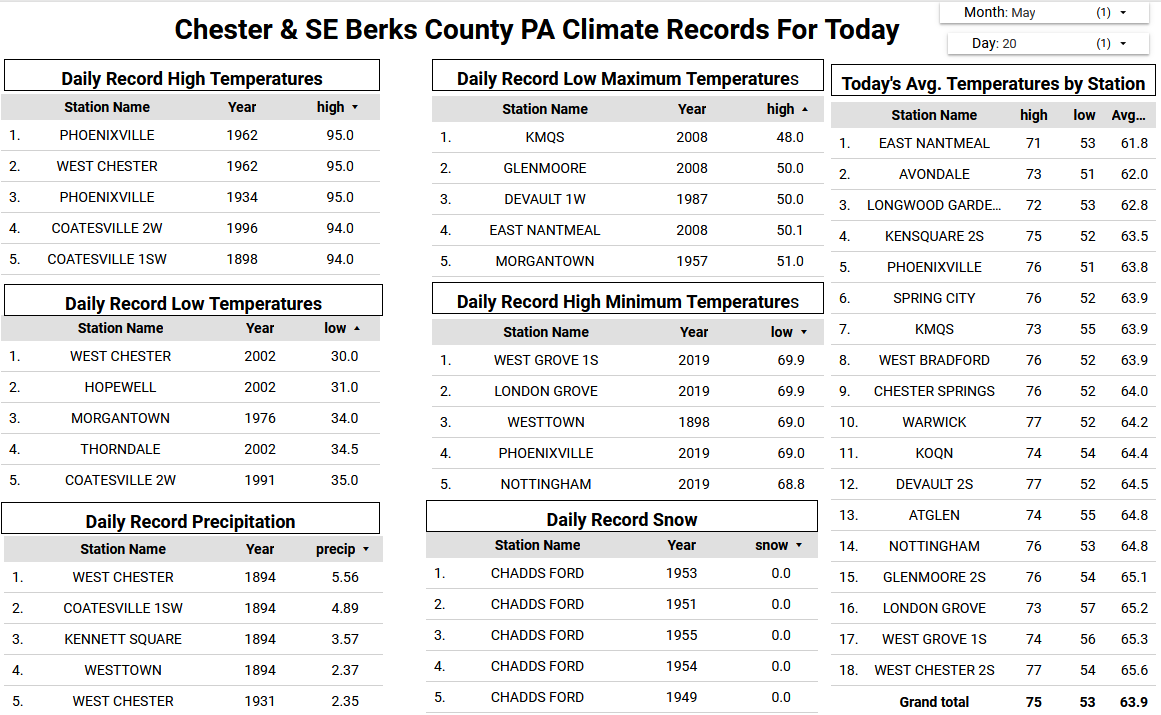
Records: Highs: EWR: 99 (1996) NYC: 96 (1996) LGA: 97 (1996) JFK: 95 (1996) Lows: EWR: 41 (2002) NYC: 43 (2002) LGA: 44 (2002) JFK: 42 (2002) Historical: 1892: Snow and high winds pelted western New England, leaving 10 inches on the ground at Strafford, VT. 1894 - A record late snow of two to eight inches whitened parts of central and eastern Kentucky. Lexington KY received six inches of snow. (The Weather Channel) 1916 - A tornado struck the town of Codell, KS. A tornado struck the town on the same day the following year (1917), and a third tornado hit Cordell on May 20th in 1918. (The Weather Channel) 1949: Eight or more tornadoes were involved along an 85 mile long track across the counties of Gray, Ford, Hodgeman and Pawnee. Newspapers in the area used headlines such as Tornado army attacks Kansas to describe the record breaking number of tornadoes, at least 40 that hit the central and western part of the state. No people were killed, but hundreds of animals perished. Four funnels were seen moving northeast about 6 miles northwest of Dodge City. A tornado moved northeast from 7 miles southwest of Coldwater, KS and just missing that town, and ending at Wilmore. The "huge rotating column" sent the entire town of Coldwater running to storm cellars. Most of the $200,000 damage was at Wilmore, as the entire town was torn apart. This is only one of two days in recorded U.S. history up to this time when 100 or more tornadoes occurred. The other was April 3, 1974. 1957 - A tornado touched down to the southwest of Kansas City and traveled a distance of seventy-one miles cutting a swath of near total destruction through the southeastern suburbs of Ruskin Heights and Hickman Mills. The tornado claimed the lives of forty-five persons, and left hundreds homeless. It was the worst weather disaster of record for Kansas City. About all that remained of one house was a small table and a fish bowl atop, with the fish still swimming about inside the bowl, rather unconcerned. (The Kansas City Weather Almanac) 1987 - Thunderstorms in southern Texas produced grapefruit size hail, near the town of Dilley ("by dilly"), and produced wind gusts to 73 mph at Lake Amistad. The large hail broke windows, killed small animals, and damaged watermelon. Thunderstorms developing along a warm front produced severe weather from Indiana to the Dakotas. Thunderstorms produced baseball size hail at Denver IA, and wind gusts to 80 mph in southern Henry County IL. (Storm Data) (The National Weather Summary) 1988 - Thunderstorms in the south central U.S. produced wind gusts to 70 mph at Omaha, NE, and wind gusts to 80 mph at Midland and Dallas, TX. Temperatures in California soared into the 90s and above 100 degrees. San Jose CA reported a record high of 97 degrees. (The National Weather Summary) (Storm Data) 1989 - Pre-dawn thunderstorms produced large hail in eastern Oklahoma and northwestern Arkansas. Later in the morning thunderstorms in North Carolina produced dime size hail at Hanging Dog. Thunderstorms also produced severe weather from the Lower Mississippi Valley to the Central Plains Region later that day and night, with baseball size hail reported around Lawn, Novice and Eola TX. (The National Weather Summary) (Storm Data) 1990 - Thunderstorms produced severe weather across the southeastern quarter of the nation through the day and night. Severe thunderstorms spawned six tornadoes, including one which injured two persons at Algoma, MS, and another which injured nine persons at Rogersville, MO. There were 119 reports of large hail or damaging winds. Thunderstorms produced baseball size hail at Houston MO and damaging winds which killed one person at Toccoa GA. (Storm Data) (The National Weather Summary) 2002: A cold wave across the eastern and central U.S. led to many cities recording record low temperatures for this day. Among them was Hartford, CT where the low of 31° was the latest in the season below freezing temperatures have been recorded. This cold wave began two days earlier with 54 record daily lows set, followed by another 96 on the 19th.
-
54 / 38 off a low of 41. Sunny and cool a bit less breezy highs around 70 / low 70s. Clouds to EPA and look to arrive in the next 6 - 8 hours or 2PM - 4PM. Miserable stretch of weather Wed - Sat (AM) showers Wed with cool onshore flow developing as trough cuts off highs in the 50s the next 3 days, coastal develops off the ULL near NJ coast and winds and rain Thu - Fri AM. Clouds and some showers linger Friday into Saturday (AM). 1.00 - 3.00 inches in the heaviest spots E/NE sections. Slowly clears out Saturday but stays cool. Sunny Sunday and Monday /Memorial Day but highs only approaching 70 / low 70s. Trough remains into the northeast to close the month with next cutoff around 5/28 - 5/29 with rain. Warmer air from the west/rockies heads east/north to open next month and a much warmer period by the first weekend next month.
-
yeah this week's a lost cause through Saturday. might see some improvement on that day but the more appreciable change comes in Sunday like others have noted. we've actually fared pretty well so far this spring at not getting into a cold-stalled scenario in the larger synoptic behaviors. most of the schlitz we've encountered has been progressive and carried on out of here in a day or maybe two. but this is more of a blocking scenario across mid and eastern Canada. I guess we're kinda "due" considering our climate in the spring. the NAO is trying to rise moving forward this week ... but there's some sort of vestigial non-linear aspect lingering, where the circulation in general still "behaves" like a train wreck- either way, we've lost the progression so things are slowed down.
-
No change in considerations for Wed afternoon-Thu night 2" g 50 part of LI and s CT. No thread as of today, per prior consideration of low stream flows and higher FFG, excepting parts of central and nw NJ. Am pretty of a gale as we're now 48-60 hours in advance for the LI shores. Regarding verification... it's how thorough we look and what we dismiss as poor siting etc. When you're out there gusting 35 knots... it becomes a significant threat to to general non-mariner. We'll see how OKX responds tomorrow regarding possible hazards.
-
Where do you get this map? Thanks
-
So it looks like the abnormal cold that was forecast is backing off a bit for my area, and most in the South East. Sure some of the high elevations could get cold, but as usual, the warmth prevails this time of year. I will enjoy the one or 2 slightly below normal temps, and low humidity. Come the end of the month though, looks like another shot of "cold"
-
Reading between the lines, the Hail outlook tells a lot. True supercells are only going to be out by the Delta. The pre-frontal trough farther east now looks like it'll be a little less volatile. Much of the severe farther east may end up bows and line segments. They can produce tornadoes, but yeah 45% wind seems to be the right issue on which to focus.
-
Haha, I thought literally the same thing.