All Activity
- Past hour
-
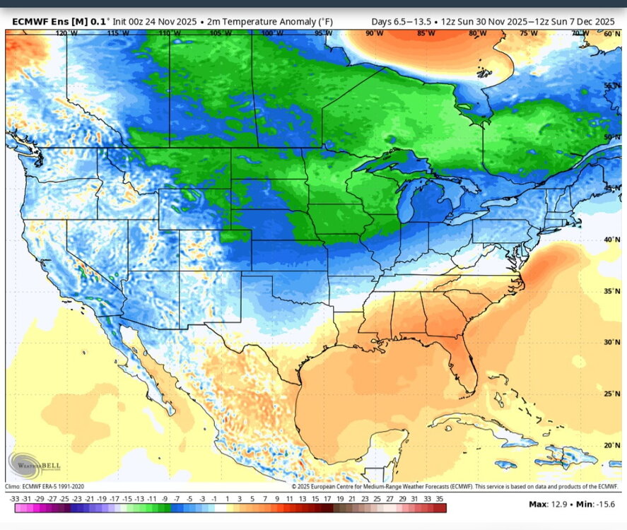
Euro weeklies yesterday vs new euro ensembles for the same week. Deamplying the ridge in the east. This is what we need.
-
Not really, worst possible scenario is the torch. A torch at Christmas is the equivalent of stubbing my toe at 3am. So you can keep that foolishness to yourself. Haha
-
Festive if anything, to open the holiday season. Maybe a whitening on the newly strung garland and lighting. Beats 62 and open golf courses in my world. LATE FRIDAY NIGHT THROUGH SATURDAY, A POTENTIALLY PROLONGED PERIOD OF WARM ADVECTION DRIVEN PRECIPITATION PAIRED WITH SUFFICIENTLY COLD TEMPS ALOFT AND AT THE SURFACE MAY SET THE STAGE FOR AN ACCUMULATING SNOW EVENT. WHILE THERE'S A LARGE SPECTRUM OF PLAUSIBLE OUTCOMES AMONGST ENSEMBLE MEMBERS, THE MULTI-ENSEMBLE PROBABILITY FOR 1"+ (10:1) SNOWFALL IN 24 HOURS CENTERED ON SATURDAY-SATURDAY EVENING IS >=60% EVEN AT THIS EXTENDED LEAD TIME. THE ECMWF/EPS DEPICTION HAS BEEN GENERALLY MORE ROBUST THAN THE OTHER GUIDANCE SUITES, BUT ULTIMATELY IT'S MUCH TOO FAR OUT FOR SPECIFICS, ASIDE FROM FEELING COMFORTABLE WITH ~60% POPS IN THE GRIDDED FORECAST. OUR MAIN MESSAGE IS TO KEEP A CLOSE EYE ON SUBSEQUENT FORECAST UPDATES AS THIS TIMEFRAME DRAWS CLOSER FOR THE POTENTIAL FOR WINTER WEATHER IMPACTS TO POST-THANKSGIVING TRAVEL. -LOT
-

Central PA Fall Discussions and Obs
mahantango#1 replied to ChescoWx's topic in Upstate New York/Pennsylvania
Just great...more wind! -
 Only looked real quick on phone but next couple weeks look windy? Storm track to west and north of region = CAA.
 -
Too soon. Let the hope and hype build for another 48-72 hours before you crush dreams.
-

2025-2026 ENSO
PhiEaglesfan712 replied to 40/70 Benchmark's topic in Weather Forecasting and Discussion
December 2021 was a very warm December in the Eastern US (I think only 2015 was warmer). If we're not going to get any snow in December, then I hope it's a torch. At least it can come back to average at some point in the winter (like January 2022). The worst possible outcome is a cooler December with no snow (like December 2022). -

November 2025 general discussions and probable topic derailings ...
dendrite replied to Typhoon Tip's topic in New England
Currently 32.3° with some snow melting. Min was 29° shortly after midnight. -
This is unbelievable. Thank you for doing this.
-

December 2025 Short/Medium Range Forecast Thread
Carvers Gap replied to John1122's topic in Tennessee Valley
The difference between 0z and 6z on the GFS is stark regarding the long range pattern. I think it likely we deal with warm temps through the first week of December, but that is not set in stone as there is a cold front possibly coming through Dec 6th(up in the air so to speak). -
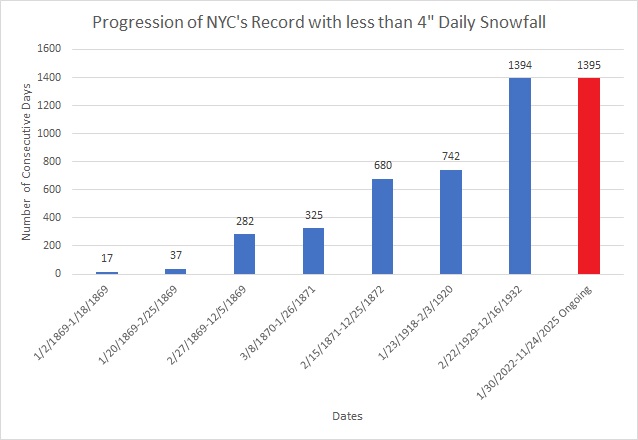
Today will be New York City's (Central Park) 1,395th consecutive day without a 4" (10.2 cm) or above daily snowfall. That will break the record of 1,394 days that was set during February 22, 1929 through December 16, 1932.
-

November 2025 general discussions and probable topic derailings ...
Kitz Craver replied to Typhoon Tip's topic in New England
EURO and GFS going for a coastal around the 5th. I believe Ray said chance of one around that period - Today
-

2025-2026 ENSO
Stormchaserchuck1 replied to 40/70 Benchmark's topic in Weather Forecasting and Discussion
Dec 2021 was one of the strongest -PNA's.. what I see on models right now is a "moderate -PNA event" in early Dec. I also don't know that it sustains beyond like a week. We'll see. If it lasts into mid-December that would be a little different from what we have seen this year (where -PNA's last 7-10 days then go away). -
Boston, MA - 53” NewYork, NY(Central Park) - 27” Philadelphia, PA - 21” Baltimore, MD- 16” Washington, DC- 13” Albany, NY- 65” Hartford, CT - 61” Providence, RI- 40” Worcester, MA - 71” Hyannis, MA - 33” Burlington, VT - 93” Portland, ME- 75” Concord, NH - 69”
-
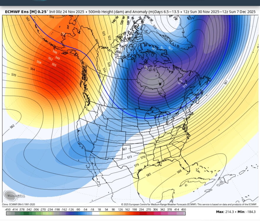
@Stormchaserchuck1 It looks like the record +PNA streak is finally about to come to an end. The ensembles (EPS, GEFS, GEPS) have the most negative long range PNA forecast I’ve seen in a very long time….years in fact
-
2025-2026 ENSO
Stormchaserchuck1 replied to 40/70 Benchmark's topic in Weather Forecasting and Discussion
I'm not going to bet you money, maybe another time, but I will bump this on Dec 14. I don't think you're going to get that snow. -
@Gawx Just looked at the new ECM zonal wind forecast, this is looking like almost a sure bet for a classic wave reflection event with a rapid recovery and strengthening of the SPV in December
-

Fall 2025 Medium/Long Range Discussion
A-L-E-K replied to Chicago Storm's topic in Lakes/Ohio Valley
Weekend duster starting to dab out and extended losing the sauce, sad -

Central PA Fall Discussions and Obs
Voyager replied to ChescoWx's topic in Upstate New York/Pennsylvania
Good temp inversion this morning. 31 at my house and 38 up in Hazleton which is 1,000ft higher than Tamaqua. -

Fall 2025 Medium/Long Range Discussion
sbnwx85 replied to Chicago Storm's topic in Lakes/Ohio Valley
I know @Chambanais pulling hard for the 00z Euro. -
-

Fall 2025 Medium/Long Range Discussion
cyclone77 replied to Chicago Storm's topic in Lakes/Ohio Valley
Looks like it'll take another day or two to work out the fine details with this lead wave. Lots of moving parts. The large scale pattern really does support a high-end storm evolving out of this immediately following the lead wave. Hope we can sync things up properly to take advantage of it. -
Still hovering just above freezing here.
-
I haven't looked at the UKMET in a while. The 0z is also significantly divergent from the (hideous) GFS as early as day 5 and pretty cold at the end of its 7 day run. It actually tries to get some snow into our area on Sunday with the weak in-between shortwave. Other guidance has this feature very weak or further north. I'm happy with any model run that doesn't send repeated cutoffs to CA. I'd love to see the ECM and EC-AI move away from the southwest cutoff at 0z.
-

December 2025 Short/Medium Range Forecast Thread
jaxjagman replied to John1122's topic in Tennessee Valley
Still look like its getting into Africa before Christmas
.png.bc299553c890ff9901eb6530194a8570.png)