All Activity
- Past hour
-
Gefs
-
Better than 12z, just manually inputted the URL to confirm lol
-
A Tuesday and a Friday. Stuck in slow traffic in the snow in the Tuesday storm, with the 1010 WINS guy saying it's looking like we'll have a repeat on Friday, which of course materialized. Best snow on snow to date for me. Neither tremendous in its own right, but with both what was on the ground already and what fell on the Friday both being substantial - it was great.
-

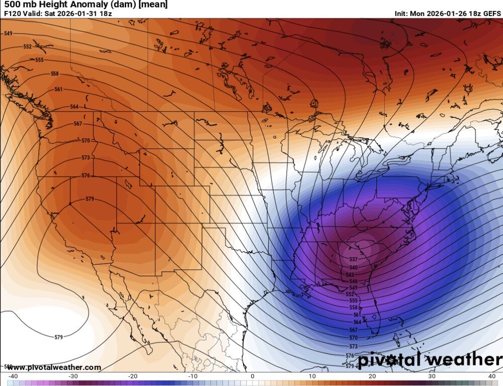
Possible coastal storm centered on Feb 1 2026.
ORH_wxman replied to Typhoon Tip's topic in New England
Well if you keep trending the main shortwave well northeast like the ICON did, eventually it will just be a low in the OH valley redeveloping off Mid-atlantic. Right now it's not doing that. -
-

Possible coastal storm centered on Feb 1 2026.
dryslot replied to Typhoon Tip's topic in New England
GFS hasn't handle east coast systems very well from longer lead times, Going to need a few more cycles. -

The “I bring the mojo” Jan 30-Feb 1 potential winter storm
eyewall replied to lilj4425's topic in Southeastern States
Smoking cirrus in Raleigh on the 18z GFS. -
 Still time for this to migrate north and west. Fun tracking ahead
 -
Here's a couple:
-

2025-2026 Fall/Winter Mountain Thread
Buckethead replied to Buckethead's topic in Southeastern States
1.4 with moderate snow. Over 3.5" now. Sent from my Pixel 10 Pro using Tapatalk -
Temps have plummeted in the last hour.! .
-

Richmond Metro/Hampton Roads Area Discussion
wasnow215 replied to RIC Airport's topic in Mid Atlantic
Icon a great hit -
 Best dendrites of the storm
 -
Yea but it’s Nina. We are lucky we for what we got
-
If you think I read through every single page of this thread, you’d be mistaken [emoji23]
-
I have not seen him on this forum in a long time. It's been ten years or more since he last posted, if I recall correctly. He had his own paywall website for a while, and a public FB page, but I don't think those exist anymore either. Sorry.
-
Gefs:
-
 That thing popped in one of the 16 windstorms we had thankfully
 -
What about trends on the Euro AIFS?
-
Not feeling this one. I hate coastals. It’s all or nothing. Overrunning lows from the SW are the way to go.
-
 You are going to be over 14 inches soon. Do I have to take back my congratulations
 -
I never saw snow like that before in Queens. The mounds were unbelievable. And then we got to 2016 and that was what my grandparents talked about when they said they couldn’t find the car
-
 Sorry not fresh, but wanted to add to thread for legacy / archival purposes... I thought this was a nice bit from the Box AFD last night detailing the storm. I'm still not sure why snowgrowth wasn't as good as many (including this AFD) expected... but with Cocorahs having generally 1.4-1.7 qpf / snow totals 15-20" (@Ginx snewx's call all week) with areas 20"+ in the expected north shore and Worcester hills... seems like SLRs ~10-12:1? Still achieved 1-1.5" / hr rates for almost entire duration. KEY MESSAGE 1...Major winter storm continues this evening and overnight. Difficult to impossible travel conditions persist through 12-2am with 1-3" per hour snowfall rates. After a bit of an early start, snowfall rates have increased to 1 inch per hour across much of the CWA this afternoon. These dangerous travel conditions continue well into the overnight as low pressure deepens offshore helping to increase mid level frontogenesis. The bulk of the snow falls through about 06z with gradual improvement into Monday morning as a dry slot works its way into the region. Storm totals are still holding steady as of the 18z update with totals expected to be in the 12"-18" range across the majority of southern New England, with 8"-12" expected on the Cape, Islands, and immediate southern coast. The higher elevations and northeastern MA will likely see 18"-24" for much of the 495 corridor including the Boston metro area. Coastal low takes shape off the Del Marva Peninsula this afternoon helping to further increase mid-level frontogenesis. In response, a deep and robust layer of lift will extend through much of the column including the dendritic growth zone (DGZ). BUFKIT soundings even show the potential for 2 favorable layers for dendritic growth, one in the mid to upper levels, and another closer to the surface with the deep and substantial near surface cold pool. Attention turns from mid level frontogenesis to lower level frontogenesis (925- 850mb) as a steep low level temperature gradient associated with an incoming coastal front approaches from the south. Coastal front initially races north across the ocean then slows to a crawl this evening as it encounters the wedge of low level cold air on land. Warm front aloft still continues north overnight, so expecting +SN to slowly transition to heavy sleet along the south coast and move inland between 00-05z Furthest inland extent looks to be along west to east corridor extending from Providence RI to Plymouth MA. In these locations the mid level warm nose increases to +1-2C. Perhaps a bit more exciting for us weather lovers is the non-zero chance for +TSSN as the mid levels warm enough for some elevated instability this evening into the overnight. Northeasterly LLJ increases to 30-40kts this evening as the low center passes just S of Nantucket. Thus, could see a period of gusty winds and blowing snow especially over the southern waters, Cape and Islands. HREF blizzard probs remain around 20%-30%, between 22 and 05z. The limiting factors for blizzard conditions along the south coast will be sleet and lower snow ratios as well as the short lived nature of the gustiest winds. Further inland, the mid level warm front stops short of changing the precip type to sleet and instead brings a lower ratio snow that that will help to cap totals between 12 and 18 inches for much of the interior. Impressive temperature gradient develops overnight with surface temps rising to near 32 as far inland as PVD but staying in the lower teens at ORH on the other side of the surface warm front! Prolific snow winds down from SW to NE as a mid level dry slot pushes into southern New England as 500-700mb RH values fall to 40- 60%. RH values like these are hostile to snow crystal growth and instead favor a period of "snizzle" or flurries. Any lingering snow eventually tapers to light flurries. Last hold out for light to moderate snow will be northeastern Massachusetts as northeasterly flow on Monday will allow for ocean-driven snow showers to persist into Monday afternoon. The next key message will better focus on Monday`s snowfall.
 -

Possible coastal storm centered on Feb 1 2026.
Typhoon Tip replied to Typhoon Tip's topic in New England
This evolution is less likely than the previous handling. +PNA ridge axis demos zero propagation toward the E between the 12z and 18z; there's really no mechanical reason to foist the deep layer farther E. If anything, the previous run ( and this one certainly by same convention - ) was too far E. -

The “I bring the mojo” Jan 30-Feb 1 potential winter storm
SouthboundYank replied to lilj4425's topic in Southeastern States
Good early reads, and TY all...but you know, if that would come to fruition, I'd gladly ask the snow gods to send that modeled wx to any of the surrounding environs except Myrtle Beach. Having said that, The Wilmington NWS team posted a good afternoon disco concerning the upcoming weekend...I couldn't include all of it in the screen cap, but there was a good two paragraphs of all of the moving pieces prior to what I pasted below.