All Activity
- Past hour
-
 2.0 _ 1.5 _ 1.8 __ 3.0 _ 3.2 _ 2.1 __ 5.0 _ 5.5 _ 1.5 101 _ 100 _ 99 __ 102 _ 102 _ 106 __ 100 _ 115 _ 98
 -

Occasional Thoughts on Climate Change
TheClimateChanger replied to donsutherland1's topic in Climate Change
Here's my little climate tidbit of the day. We can't even imagine how cold it used to be. There was so much ice in the upper lakes following the absolutely frigid winter and spring of 1836-1837, that the Saint Clair River closed to navigation in June as it was flowing downstream. -
If a cold summer followed an El Nino winter (which doesn't happen often like 1992), then expect the upcoming winter to be either Neutral or a 2nd-year Niño.
-
On June 1, 1837, the St. Clair River between Lake Huron and Lake Saint Clair closed up with ice. The schooner New York became caught in the ice at Recors Point and was carried downstream. In the same year, ice was harvested from the river until July 4th.
-
Occasional Thoughts on Climate Change
TheClimateChanger replied to donsutherland1's topic in Climate Change
First of all, the digits are Tony's rankings, not percentages. In fact, it looks like 82-83 percent of stations have reached 80F. But more importantly, this is a meaningless statistic for a number of reasons. It's affected by the average elevation, latitude, urban character, etc. of the station mix. If there's a higher percentage of stations in high latitudes and/or higher elevations, you would expect a lower percentage to have recorded an 80F day before the end of May [also, I doubt all of May 2024 has been included in the data -- the month is just now ending]. Further, it's affected by equipment changes. It's well established that a lot of the automated stations report somewhat lower maxima than traditional LiG thermometers housed in a shelter. Even ignoring all this, it's not really meaningful. It looks like pretty much every year at least 80 percent of stations have reached 80F by May 31. There's only about 15 percent or so of stations that vary in a given year - many of which are probably in the same general area [somewhere in the northern US]. Many of these places probably don't see 80+ until late in the spring, so all it would take is a cool spell in May to keep them from reaching that temperature. Meanwhile, the rest of the country could be baking... and even the places that fail to reach 80F might have been way above normal for the majority of the year. -

Central Pa. Spring 2024
Blizzard of 93 replied to mahantango#1's topic in Upstate New York/Pennsylvania
CTP strongly disagrees. Here is their current point & click forecast for Lancaster on Sunday. Sunday Partly sunny, with a high near 80. Calm wind becoming south 5 to 8 mph in the morning. - Today
-

2024 Spring/Summer Mountain Thread
Maggie Valley Steve replied to Buckethead's topic in Southeastern States
What an amazing stretch of weather! There's nothing better than mountain living!
-

May 2024 Discussion - Welcome to Severe Season!!!!
powderfreak replied to weatherwiz's topic in New England
The long daylight, warm afternoons, chilly radiational evenings…. it’s just pristine weather. Down to 52F with a 10F drop in an hour as the sun goes down. The rad pits cool off well in this type of air mass the past few days. Low dews are the clue to radiational cooling. TAN at 54F and vacating heat.
-
They'll eat worms and some crawling bugs but they're not gonna chase down a flying bug. They are peckers.
-

Occasional Thoughts on Climate Change
donsutherland1 replied to donsutherland1's topic in Climate Change
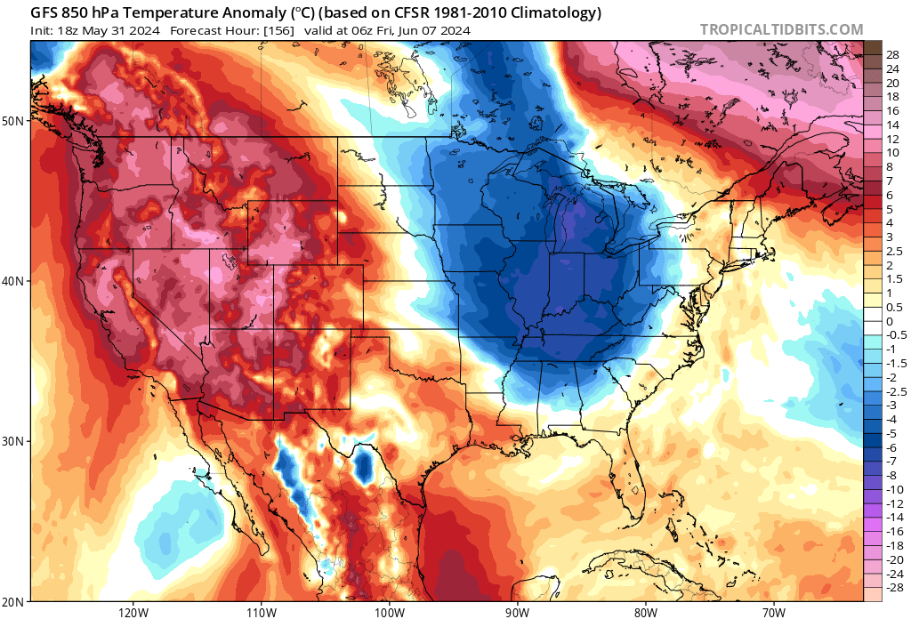
Far more meaningful for evaluating temperatures than Tony Heller's chart are the mean temperatures, mean low temperatures, and mean high temperatures. There is virtually no chance that 2024 will rank as the 4th coldest January-May on record when all the data is considered. Once the NOAA compiles the May data, the January-May 2024 period will likely rank as among the 10 warmest in terms of mean temperatures and mean low temperatures and among the 25 warmest in terms of mean high temperatures for the contiguous United States -

May 2024 Discussion - Welcome to Severe Season!!!!
ineedsnow replied to weatherwiz's topic in New England
can we just let the whole summer be like this? -
Welcome to meteorological/climatological summer.
-
Forecast Discussion Tuesday, August 13, 2024 11:58AM EDT A dangerous day of tornadoes is already underway. Make sure you know where your safe place is in your home (basement or interior room in the lower floor of a house or apartment). Arc of heavy rain and embedded supercells, some of which are tornadic, continues to lift north through the region and into northern/central MD with the warm front feature that has developed to the ENE of Joyce’s surface low center. With a potent shortwave trough swinging in and phasing with Joyce’s low pressure center, a mid-level dryslot has wrapped around the surface low to the east across Virginia and getting into Maryland along and south of the warm front. This is what’s allowing for some sunshine to continue to overspread the region. Dewpoints have risen into the upper 70s to around 80F south of the front and with the added sunshine temps will rise into the mid/upper 80s this afternoon. This combined with a modest cooling of mid-level temps associated with the approaching shortwave will allow for unusually large CAPE for a remnant tropical system (MLCAPE of around 2500 J/kg or so). The shortwave is also deepening the surface low so, as a result SE surface winds will strengthen across the region with 25-35 kt gusts commonplace. Hodographs will also be very large and curved with a strong 60+kt LLJ overhead resulting in effective SRH easily in excess of 400m2/s2. The sunshine combined with the ample low-level moisture will allow for large 0-3km CAPE of 250-300+ J/kg. All of this combining with 45-55kt effective bulk shear to make conditions highly favorable for a potentially significant tornado outbreak across the region. Currently some supercells which have already caused a number of confirmed tornadoes continue to move NNE into northern and central MD. To the southwest across central and southern VA along and east of the mountains arcs of low-topped supercells, some of which have ongoing tornadoes, continue to mature and strengthen with the increasing instability. As the afternoon progresses bands of supercells will move quickly through the area from SW to NE. These supercells will likely produce several strong to intense tornadoes, some long-track. The Storm Prediction Center is considering an upgrade to a HIGH risk to account for the tornado threat. Due to the slight cooling and drying of the mid-levels, these storms could also produce severe hail as large as 1 to 1.5 inches in diameter. Even if there is no tornado with a particular storm, the 2.25”+ Pwats and large CAPE combining with strong low-level flow could aid in wet downbursts/microbursts bringing severe surface wind gusts. Storms will move to the northeast and exit the area by mid evening as Joyce’s center moves across the region. By the late evening hours the cold front associated with the strong shortwave trough will move through from west to east bringing a 3 to 6 hour window of northwesterly winds gusting 40 to 50mph. A Wind Advisory is in effect for the region to account for this. Temperatures and humidity will fall sharply with this front. Winds will start to weaken towards dawn with temps bottoming out in the 50s in the Greater Metro regions with upper 40s in the far northwestern suburbs. The bottom-line is that this is the beginning of one of the most dangerous tornado outbreaks to impact this area. Please be weather aware and ready to get to your safe places the moment a tornado warning is issued. Wearing a helmet and closed-toed shoes while in your safe place is essential as well to protect from flying debris during a tornado and debris in the aftermath of a tornado. Stay tuned to the NWS for the latest updates available during this event. Forecaster Wannabe: George BM
-
I thought that was what the chickens were for, other than fresh eggs for breakfast more often than not. 76 at KIND today also but our dews were only in the low 40's. You win today!
-
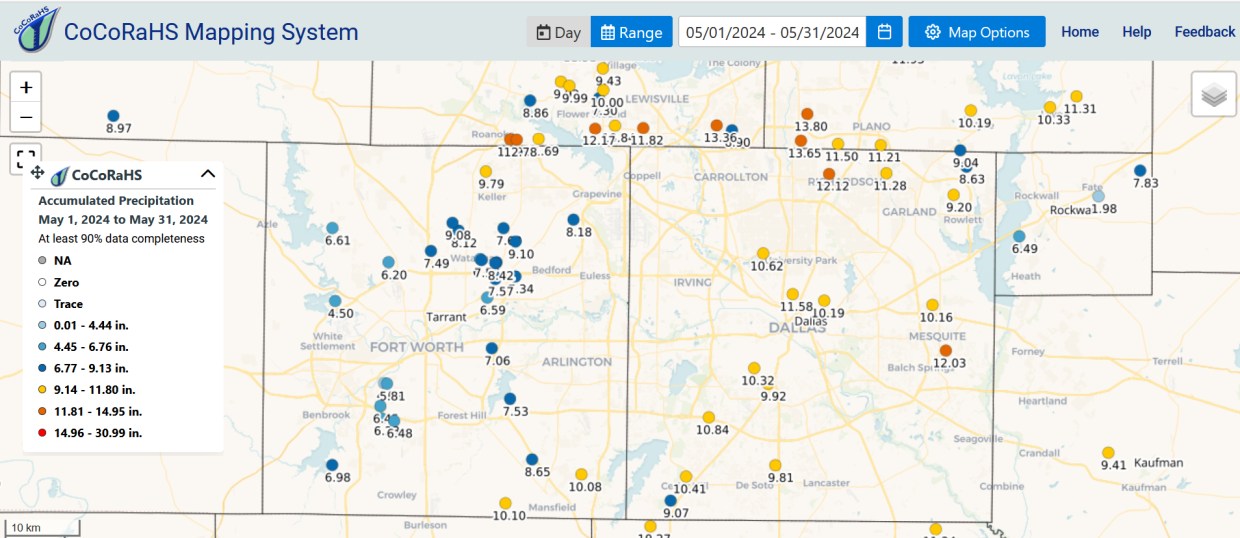
Dallas County had a foot of rain in May
-

Central Pa. Spring 2024
mahantango#1 replied to mahantango#1's topic in Upstate New York/Pennsylvania
77 was my high today. May total rainfall 6.07in. -
Had a low of 44 with a high of 66 and current temp of 56 beautiful degrees!
-
Another wet month ahead on tap...latest WB EURO weeklies. Second week of June below average.


-
100% expected actually given upcoming MJO progression/tropical forcing response. Won't last long tho, so enjoy.
-
 DCA: +2.0 102 NYC: +1.8 100 BOS: +1.7 99 ORD: +2.4 104 ATL: +1.5 102 IAH: +2.0 107 DEN: +2.4 104 PHX: +1.8 120 SEA: +1.3 99
 -
Highs: EWR: 79 ACY: 78 JFK: 78 TEB: 77 New Brnswck: 77 PHL: 77 ISP: 76 LGA: 76 TTN: 75 NYC: 75 BLM: 74
-
I’ll die on the hill of -10F < +90F as a fellow outdoor worker call me crazy but I move slow when it’s Arctic conditions haha
-
Yea, when we see the sun. The GFS sits a low over us for multiple days of showers and rain. Send that junk up to NE and extend their mud season.
-

May 2024 Discussion - Welcome to Severe Season!!!!
Sled replied to weatherwiz's topic in New England
Widowmaker. I need to get a hard hat. -
 DCA _ NYC _ BOS __ ORD _ ATL _ IAH __ DEN _ PHX _ SEA 0.5 0.7 1.0 1.0 0.5 2.3 1.5 2.1 1.5 98 98 96 99 97 102 101 120 95