All Activity
- Past hour
-
That John Denver guy is full of s***.
-
There are two micro climates on either side of the mountains from spring thru early fall there for about a 30-50 mile stretch S to N. When the wind direction is S to SW and storms form a tornado/hail alley is common from Greenville up to Grottoes on Rt 340 corridor and east side likes to form severe T-storms from C'ville up to Culpeper on Rt 29. I'm 99% sure the ridge there enhances stuff.
-
Until we get the mean trough to set up just up just to our west, we will have a repeat of last year....CAD with dusters here and there, always on the verge of a warm up. Hope that thing can dump just to our west but we need the PNA to cooperate.
-
At minimum, should at least be first flakes of the season for dc/annapolis. It would be pretty lame to go much longer not getting a trace in this pattern. We’re still at goose eggs at each airport. In Frederick, we already had a couple of coatings by mid-December…confirmed via camera roll.
-

December 2025 regional war/obs/disco thread
40/70 Benchmark replied to Torch Tiger's topic in New England
I'm going to stare at a series of terminally ill looking vorts and hope one digs enough to give me an inch. -
Thermal profiles are all over the place, both observed and forecast. Near freezing in the valley (Hendersonville, Asheville), 45F here at 3550', but up at 4230' (Bearwallow), it is 41 F. Going to be interesting to watch this profile flip, according to short range models.
-
I would think air that cold will drain south and east and cause wintry chances even if you aren't under the blue negative height anomalies.
-

December 2025 Short/Medium Range Forecast Thread
jaxjagman replied to John1122's topic in Tennessee Valley
Keep seeing it being to warm while the clown maps keep saying you'll get IP and SN,looks more cold rain here -

December 2025 regional war/obs/disco thread
TauntonBlizzard2013 replied to Torch Tiger's topic in New England
Wait, a fraudulent Norlun event, followed by dying clippers traversing 500 miles north of us doesn’t move the needle for you? -

December 2025 regional war/obs/disco thread
40/70 Benchmark replied to Torch Tiger's topic in New England
He gets excited over everything. -
We have the good karma going this year, I predict this one doesn't crap until MI
-
Yesterday's record snow for the date from 1971 when it used to snow more than a half inch. 16.3 inches. Of course, even a half inch is a struggle. YESTERDAY 0.0 16.3 1971 0.0
-

Central PA Fall Discussions and Obs
pawatch replied to ChescoWx's topic in Upstate New York/Pennsylvania
What for weather stations are most of you running? Ambient weather stations, Davis? Thinking after the first of the year upgrading my weather station. 30 degrees and snow flurries. -
They’re fun to bike and hike, though.
-

December 2025 regional war/obs/disco thread
weatherwiz replied to Torch Tiger's topic in New England
Maybe for Australia. JB gets excited about whatever will get him more clicks and subscriptions. JB could craft a post about how a family skunks spraying a dog in Colorado will translate to EC cyclogenesis and he'll gain 300 followers and re-posted information all over social media -
JB gets excited about the SOI. He has always said that watch out when the SOI tanks. Active weather will be on the way.
-

December 2025 regional war/obs/disco thread
SouthCoastMA replied to Torch Tiger's topic in New England
Oh how we pray that something akin to the 6z OP GFS pans out in the 12/15-12/21 timeframe. -
decent trends on this one, these nw flow waves can flip flop either way so it's nice to see this one picking up some steam again looks like 2-3 more in the pipeline, so any overlap areas could add nicely to their totals before temps look to become more problematic mid month
-
12k is noticeably drier this run for dc. This storm is fizzling on approach.
-

December 2025 Short/Medium Range Forecast Thread
Carvers Gap replied to John1122's topic in Tennessee Valley
Yeah, I don't trust any model at this point. Glad I don't have to put out a product tonight to the public! This is one of those which could bust either way. -
I also hate the mountains.
-

December 2025 Short/Medium Range Forecast Thread
Carvers Gap replied to John1122's topic in Tennessee Valley
Jax, looks like basically a reload. Lots of conflicting signals there. Great share. -
I’m like Griswold’s boss on the phone right now. “just give me something….anything!!”
-

The Return of the 12/5 Snowstorm
NorthArlington101 replied to SnowenOutThere's topic in Mid Atlantic
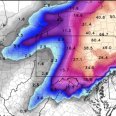
I think there is a pretty solid consensus right now that DC is about the northern extent of an inch. Further south - and you don't have to go too much further south - 1-3" seems right down to RIC. A casual 50mi shift north would help many of us, but some minor accumulations would be sweet.


