All Activity
- Past hour
-
Its actually tomorrow afternoon while my forecast is 45 and partly sunny
-
(002).thumb.png.6e3d9d46bca5fe41aab7a74871dd8af8.png)
E PA/NJ/DE Winter 2025-26 Obs/Discussion
ChescoWx replied to LVblizzard's topic in Philadelphia Region
-

Outta gas and Outta Time: Early March Winter Storm finale
stormtracker replied to Ji's topic in Mid Atlantic
Just looking at the GFS now and you just gotta laugh at how there's a ton of cold pressing just on top of us and the GFS in previous solutions not holding on to snow or frozen. Maybe this run will change -
-

Clipper Fires In Wednesday Feb 25 Disco/ Obs
Great Snow 1717 replied to Damage In Tolland's topic in New England
It is still snowing... -
Great to have you back doing PBP - much appreciated.
-

Clipper Fires In Wednesday Feb 25 Disco/ Obs
40/70 Benchmark replied to Damage In Tolland's topic in New England
Ha probably an inch. -
Since it is next, figured I would look at the UKMET trends leading in. FWIW it is trending more amped and a touch slower. It brought the precip a good jog north at 06z responding to this change. Another nudge like that and we probably get more precip at 12z. But I am not expecting snow even with an amped nudge; UKMET seems to run pretty warm.

-

February 2026 OBS & Discussion
WeatherGeek2025 replied to Stormlover74's topic in New York City Metro
GFS still shows that snow for tomorrow night. -
Clipper Fires In Wednesday Feb 25 Disco/ Obs
Great Snow 1717 replied to Damage In Tolland's topic in New England
Will update later on but I need to find something longer than a yard stick.... -

E PA/NJ/DE Winter 2025-26 Obs/Discussion
Duca892 replied to LVblizzard's topic in Philadelphia Region
Refreshing every 60 seconds for the 12z GFS for next week -
For tomorrow night?
-
Low of 14 and 1.25 inches of snow now it jumped quickly to 38 / 30. Clearing out and the melt-off resumes. Icicles from the house are quite the site / danger. 5 days of 40s and 50s (Saturday) will make a sizeable dent in the snow pack. Monday- Wed next threat GFS coldest and snowiest. Much colder in the 3/5 - 3/7 period before moderartion to and perhaps much above in the 3/8 - mid month period.
-

2/24 - 2/25 Clipper Obs (1 - 2" for many on forum)
Stormlover74 replied to Northof78's topic in New York City Metro
Yes I was being sarcastic -
72” after this one in Sherman CT. 13” to go for the biggest season since 1995-96 (117”).
-
The siting of the ASOS in Central Park is poor. A large chunk of heavy, wet snow could easily fall into the gauge from nearby trees during a wind gust. In addition, the lack of any augmentation and backup causes periodic erroneous measurements. The AWPAGs in ASOS are much better with frozen precipitation than the heated tipping buckets, but they are not foolproof. NYC deserves better. While the mesoscale models and NBM forecasted more accurately along the coast, the ECMWF and UKMET did the best in western NJ and eastern PA. Both opposing model solutions were accurate and inaccurate, at the same time. A Blizzard Warning 20+ miles west of NYC was not needed as the criteria was never met. In Somerset County, NJ I measured 12”, the NWS forecasted 15-26” and the NBM consistently forecasted about 20”. The errors were even greater further west. All in all an impressive and well forecast storm. It’s too bad the climatological record needs to be QCd, corrected and amended post-event. The ASOS at EWR is in Union County on the southeast corner of the airport property. Snow is measured approximately 2 miles northeast of the ASOS in Essex County. It’s still on airport property but the county boundary slices the airport in half.
-
ok thanks, yeah i know Jack. Thats great to know because those two reports line up extremely well so part of me thought they were the same reporter, good stuff. Vary narrow band of 20"+ in W CT, those reports are really close which is good for such a big long duration windy storm, i was just surprised to see 22 and 21 right next to each other
-
^ lol I guess it's not a surprise that they're different but 30% is a pretty big difference so I figured it was worth mentioning. I'm too stupid to remember to write things down so I'm not sure. I looked back through our threads at my posts the other day and came up with about 50 and didn't go back further. I'm sure I missed one or two small ones and only went to like mid December so...
-

Clipper Fires In Wednesday Feb 25 Disco/ Obs
WinterWolf replied to Damage In Tolland's topic in New England
Agreed. 13-15” here in the blizzard…so I know what you mean. Great storm but could have been double that amount if I got into the big banding more. But you win some, you lose some. Feb 13 pretty much jacked here. This one no dice. But it’s been a great winter so far. -

Clipper Fires In Wednesday Feb 25 Disco/ Obs
512high replied to Damage In Tolland's topic in New England
1" ASH/ 22F -
Really on an island
-
AiGfs barely clips MD/DCA and south compared to Gfs. Hardly any qpf north of PA/MD border.
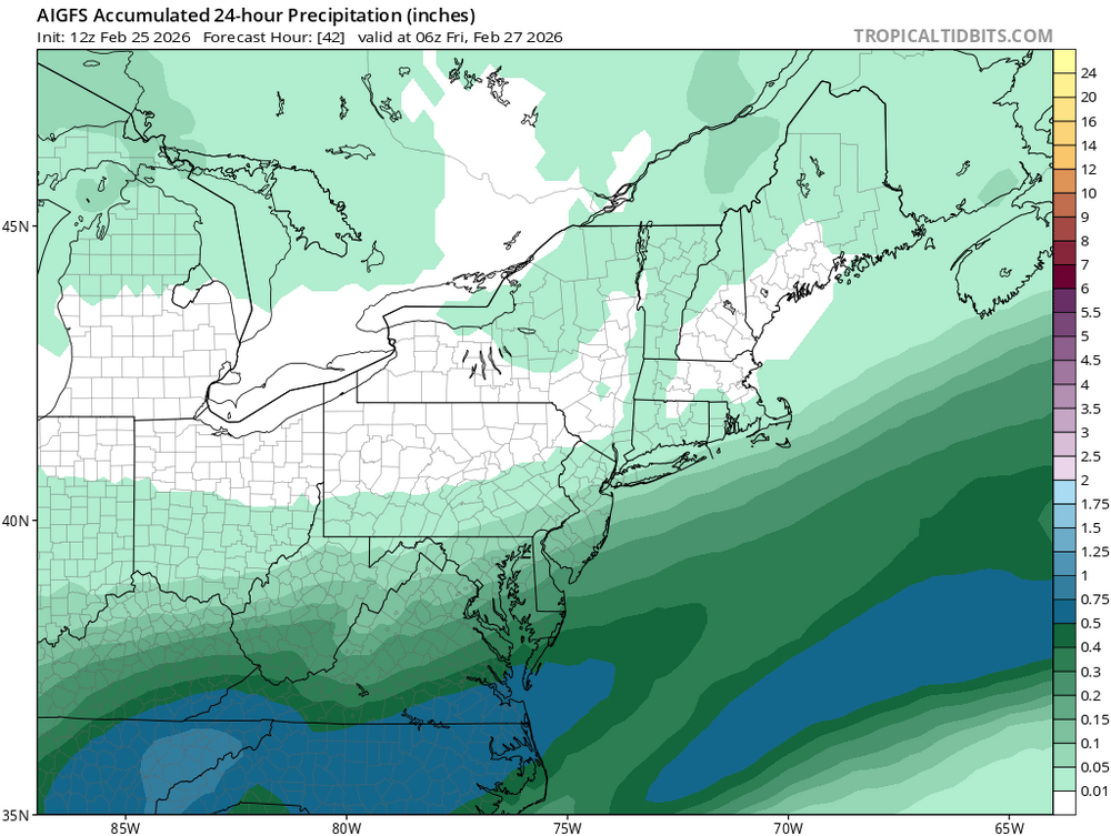
-
AIGFS also north. Even still, not much more than an inch On an island again - But I think this time it caves hard
-
AIGFS did come north but temps are bad.
-

"Don’t do it" 2026 Blizzard obs, updates and pictures.
The 4 Seasons replied to Ginx snewx's topic in New England
definitely... that whole package in that video is just something that would be absolutely priceless, i mean just amazing to have for every storm (at least modern storm)..man.