All Activity
- Past hour
-
Looks like an at least EF-3 hit Appleton, WI
-
.10" here, north side of town .37
-
 Cherry picking.
 -
2009 was one of my favorite summers back in Long Beach. Comfortable temperatures and smaller beach crowds. Really the last time that we had a cool June and July by long term climate standards. The 19th coolest June and July average temperature at Newark with records now back to the 1840s was very impressive. The actual coolest average temperature since 1940. Time Series Summary for NEWARK LIBERTY INTL AP, NJ Coolest June 1st to July 31st Periods. Click column heading to sort ascending, click again to sort descending. 1 1859-07-31 67.8 0 2 1862-07-31 68.2 0 3 1903-07-31 68.3 0 4 1857-07-31 68.8 0 5 1867-07-31 69.1 0 - 1863-07-31 69.1 0 6 1924-07-31 69.3 32 7 1860-07-31 69.5 0 8 1861-07-31 69.6 0 9 1902-07-31 70.1 0 - 1871-07-31 70.1 0 - 1864-07-31 70.1 0 10 1916-07-31 70.2 0 11 1918-07-31 70.5 0 - 1907-07-31 70.5 0 - 1869-07-31 70.5 0 12 1904-07-31 70.7 0 - 1851-07-31 70.7 0 13 1893-07-31 71.0 0 - 1875-07-31 71.0 0 - 1855-07-31 71.0 0 14 1868-07-31 71.1 0 15 1881-07-31 71.2 0 16 1897-07-31 71.3 0 17 1915-07-31 71.4 0 - 1914-07-31 71.4 0 18 1940-07-31 71.5 0 - 1884-07-31 71.5 0 - 1873-07-31 71.5 0 19 2009-07-31 71.6 0 - 1874-07-31 71.6 0
-
 That only goes through 12z Wednesday
 -
My cell and a bunch of others have SOS. No cell signal. Weird. In different towns too
-
https://x.com/Real_Wookie/status/2081800492649206062/video/1
-
 Wags west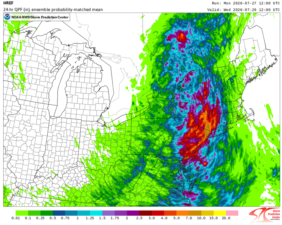
-
Warning for northern Middlesex Pretty stationary
-

Spring/Summer 2026 Pattern Discussion Thread
Carvers Gap replied to Carvers Gap's topic in Tennessee Valley
This is about the time of year that I start looking for the first fall air mass on ext LR modeling. Nothing is clear right now. All eyes are on Alaska. If we can stick a ridge in Alaska during late August, that will be something we haven't done in long time, especially at that time of year for any length at all. -
Midnight high of 76. Been in the 60's today. Early Fall feel again. Chilly actually.
-
A few storms popping up now
-

E PA/NJ/DE Summer 2026 Obs/Discussion
Hurricane Agnes replied to PhiEaglesfan712's topic in Philadelphia Region
Have been watching the cell just SW of Allentown. it seems to be reforming. -
I had my biggest Winter last year since returning from CA in 2017, 24" here. -AO was the reason for that: but it was a dry pattern. In normal precip we could have done better. Kind of disappointing the last 2 Winters have been cold with below average snowfall.
-
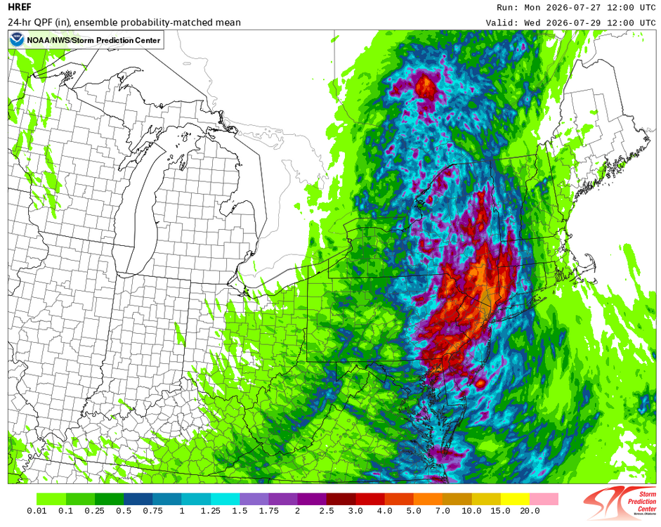
The 7/27/2026 12z HREF:
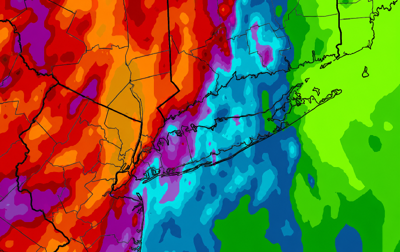
-
If I had to make a Winter prediction it would slightly lean towards above average snowfall. The reason is the AO may be negative a lot of the time, and that combined with El Nino STJ can really produce some big storms. On the other side the Pacific is not looking El Nino like at all, -PNA dominates, so we could be looking at a Winter overall above average temp wise with possibly average to above average snowfall.
-

E PA/NJ/DE Summer 2026 Obs/Discussion
LVblizzard replied to PhiEaglesfan712's topic in Philadelphia Region
There’s been near constant thunder here for over 3 hours. Our only break was an hour ago when the first storm left and the second one hadn’t formed yet. -
I agree that this is pretty typical for Monsoon-time. The monsoon doesn't produce days and days of widespread heavy rain aside from a few lucky spots....but in years where it fails, it has severe consequences and it's absence has a remarkable effect. A big example is the 2020 "non-soon" which essentially created a summer of very low humidity + heat and that didn't end well.
-
E PA/NJ/DE Summer 2026 Obs/Discussion
Hurricane Agnes replied to PhiEaglesfan712's topic in Philadelphia Region
Sun back out. Finished up with 0.90" of needed rain. Currently 71 with dp 71. -
Question for tomorrow. Do we see increased cloud cover late morning and early afternoon? Or do we clear out? That's gonna be the deciding factor. Girlfriends flight lands around 8pm tomorrow evening at the charlotte airport. Might get interesting.
-
No 90 most likely today. Good trade off tho with the explosive storms
-
Substantial tree damage reports coming out of Marion, IN according to police traffic. One structure with roof damage as well.
-
Did not take long to mix out, back up to 85/78/97
-
Basement flooding is always a treat
-
 And to think there are people here who want to be impacted by an F3 or higher tornado.....