All Activity
- Past hour
-

2026 Atlantic Hurricane Season
dbullsfan replied to Stormchaserchuck1's topic in Tropical Headquarters
any hope for this thing to make some noise in the gulf? -

2026-2027 Super El Nino
snowman19 replied to Stormchaserchuck1's topic in Weather Forecasting and Discussion
As suspected, given the super El Niño/++PMM, the EPAC tropical cyclone season is shaping up to be a blockbuster In other news, even the notoriously too cool CDAS daily has region 1+2 at almost +3.5C now -
Much better here than yesterday, but still higher AQI in the 500's around DLH. Rains heaviest up on the border where they really need it with some passing showers here in town. Not quite out of the woods yet.
-
I recall a string of Virginia forest fires while attending Virginia Tech in the 90s. It was so bad that the back of my throat was irritated. I don't even think they canceled classes though. lol
-
 Pretty clearly a circulation formulating west of Sarasota
 -
Its awful here still, we are at 1 1/4SM with the smoke and the AQI is around 400 still.
-
Similar upper level air flow looks possible next week. Wonder if it comes in over us again.
-
Forky please keep SPF 100 handy in case of unexpected clearing. As always …..

-
Would have loved that over my house.
-

-
I agree. I think we will be also having a lot more "mixed" or snow to rain events east of the i81 corridor/mountain regions this winter. I'd like to think if we can time it right with the cold air - as I believe we will see numerous moisture laden SLPs - we could luck our way into a decent winter.
-
My son had a tennis match today. The tennis club canceled all programming. Good thing I chose not to practice outside yesterday as well. He has mild asthma. We saw the haze on the way to his camp this morning.
-
Satellite shows the smoke has pushed south but it’s deceiving, still lots of lingering ground level smoke easily seen when outside.
-
I suppose we were due for this. Over the past 50 or 60 years precipitation has increased quite a bit. That 46 inches in 2024 would have been above normal some 50 years ago.
-

Central PA Summer 2026 Discussion/Obs Thread
Jns2183 replied to Voyager's topic in Upstate New York/Pennsylvania
My air quality monitor finally paid of. I have it upstairs in my daughter's room. The 4.0 has been a bit worse than 2.5 and 1.0. regardless they have peaked in the aqi range of 104-115 inside Sent from my SM-S731U using Tapatalk -
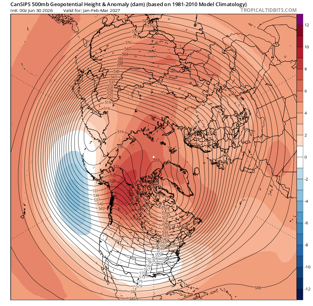
The CanSIPS advertised h5 pattern for latter part of winter certainly implies cold enough at times. Love the look out west with the Aleutian low placement and the amped EPO ridge. Has the TPV in a favorable spot and suggests a -NAO.
-
We have an air quality meter here at Coppin on our building that's on AirNow. Current AQI is 262
-

Pittsburgh PA Summer 2026 Thread
Gordo74 replied to TheClimateChanger's topic in Upstate New York/Pennsylvania
Anyone have good smoke models/maps to show over the next few days? -
I've seen / been in worse when I was in North Dakota directly down range... but not much worse. This is crazy for this area.
-
Wondering if the Morgan Wallen concert at M&T Bank Stadium will be affected. AQI is supposed to be horrid during that time.
-
Cancelled practice on deck. Seems to be a little bit better now as the ABL should keep rising.
-
looking forward to the soot rain tomorrow morning. i love climate change
-
Rarely is. Probably a line of storms but who knows when. Evening I guess
-
 This coming Monday marks 30 years since MWN's windiest met summer day - the 24-hour average was 99 mph, IIRC. Friends were getting married at our (then) church in South Gardiner, with an outdoor reception under a large tent, and the wind would work the 4-foot "pins" upward such that we had to monitor them while carrying sledge hammers.
 -
Not to toss a wet blanket on this - I love this look, and while it points to a relatively stormy winter for is - I think the ridges will verify stronger and troughs weaker. The more important interpretation of this map is the placement of the troughs and ridges. The trough placement for us is perfect (TN), western ridge axis over Idaho. The E Canada ridge may verify in the same place, but would be more extreme - double digit warm anomalies with blocking that may give us some interesting storm tracks. Please, please just have it cold enough for us.