All Activity
- Past hour
-
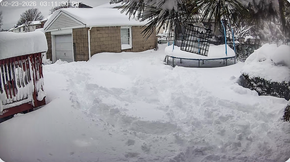
I’m still rain weary after Helene. Hate that I used to enjoy the rain so much but ever since the storm I’ve just always hated downpours and have to keep an eye on the yard, the way the water is flowing, etc. I’ll definitely take the rain but just in calm, non-intense varieties.
-

E PA/NJ/DE Spring 2026 Obs/Discussion
The Iceman replied to PhiEaglesfan712's topic in Philadelphia Region
I didn't get much either, but it did at least wet the ground... I didn't even bother to check the gauge, probably .05" tops. -
I'm at the hospital with my mom in the Detroit area (Novi). Was here yesterday and a crazy intense storm blew through. It was like derecho winds. You know those large public trash bins that are made of cement and this pea gravel looking stuff always in public locations? I was watching out the window of her room during the storm and the wind blew one of them right over! They must weigh several hundred pounds. Was about 90F here yesterday. 53F today when I got to the hospital this morning, much colder.
-
Agreed. The nature of pulse thunderstorms is there will be winners and losers so some of us may need to wait until the weekend/next week to get significant rainfall
-
all the mesos this morning are impressive
-
extended looking p zzzzzz, at least temps looks pleasant and comfortable
-
85/65
-

Central PA Spring 2026 Discussion/Obs Thread
Itstrainingtime replied to Voyager's topic in Upstate New York/Pennsylvania
Going to be close but I think we have a good shot at hitting it - I'm at 84.5 currently and it looks like another 2-3 hours of full sun to go. -
really could have used that rain
-
81 DCA 83 IAD 87 BWI 10am obs
-
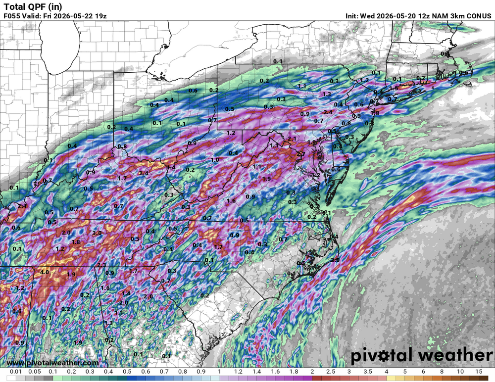
3K NAM clobbers the S Coast later today/this eve
-
Accomplished with ease these days.
-
My excitement is building. Pulse thunderstorm season is one of my favorite times of year. Hope this wedge doesn’t last too long and we get to see some fireworks over the next few days.
-
06z GFS is 2"-3" from I-70 north Friday into Saturday.
-
FRG 85/65 at 10 am.
-
Should be some today.
-
send some of that up this way. silver spring is going to just be "silver" soon
-
MAV has 23° at SLK Fri morning. Terrible.
-

Central PA Spring 2026 Discussion/Obs Thread
Superstorm replied to Voyager's topic in Upstate New York/Pennsylvania
Record heat to record cold maximums. Gotta love springtime around here. -

E PA/NJ/DE Spring 2026 Obs/Discussion
Hurricane Agnes replied to PhiEaglesfan712's topic in Philadelphia Region
Well the diffused blob was so diffuse that I got nothing from it other than more humidity. I bottomed out at 70 this morning and it's currently 86 with a dp of 70 (which should be banned anytime before July). I did see the upcoming forecast for rain on and off into the weekend so hopefully I get something from that (looks like an overrunning event along the cold front). -
Can't wait to watch the cumulus build over the Blue Ridge the next few weeks
-
-
-
E PA/NJ/DE Spring 2026 Obs/Discussion
The Iceman replied to PhiEaglesfan712's topic in Philadelphia Region
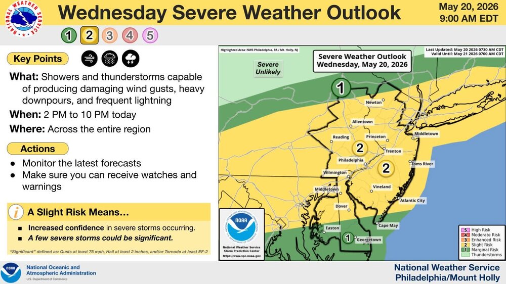
TTN and PHL record high is 94 for 5/20, KABE is 92. All 3 should have a shot at breaking it. SPC has upgraded the area to a slight risk for wind this afternoon/evening, looks like we should see several rounds of scattered storms beginning after 18z then most models are showing an area of steady rain with the front now overnight into tomorrow morning, should hopefully be a decent soaking. This weekend is also looking like a much needed washout, it's a shame though it's Memorial Day weekend. Maybe we can get Sunday mostly dry, but looking like showers/rain/cool most of the weekend ...Ohio Valley into the Mid-Atlantic and Southern New England... On the southern fringe of upper troughing over eastern Canada and the Great Lakes, a weak/convectively augmented mid-level shortwave trough will progress northeastward across the OH Valley and central Appalachians through the day, eventually reaching the Mid-Atlantic tonight. Robust daytime heating of a modestly moist low-level airmass (surface dewpoints generally in the low to mid 60s) ahead of a surface cold front will aid in the development of moderate instability by early afternoon. Ongoing convection across OH/KY this morning may eventually strengthen as it encounters this destabilizing airmass, and additional thunderstorms are expected to develop along/near the cold front by mid afternoon from the central Appalachians into portions of the Mid-Atlantic and southern New England. Stronger flow aloft will tend to lag/remain north of the cold front, but modest enhancement to the west-southwesterly mid-level flow along/near the front should support around 20-30 kt of deep-layer shear. This will be sufficient for some updraft organization with mainly multicells expected, although marginal supercell structures may occur. Low-level lapse rates are expected to become quite steep through the day, evidenced by a general lack of clouds on recent visible satellite imagery from central/eastern WV into the Mid-Atlantic. This will likely aid efficient downward momentum transfer in convective downdrafts, with scattered severe/damaging winds possible as multiple clusters spread east-northeastward through the afternoon/evening. Isolated hail may also occur with the stronger cores. A Slight Risk for severe/damaging winds has been introduced from parts of WV to southern New England given increased confidence in multiple clusters traversing a narrow zone along/ahead of the front.