All Activity
- Past hour
-
38 again. Can’t figure my area out. Last was the warmest in my area, 2 nights ago the coldest.
-

2026-2027 Record-breaking El Nino
LakePaste25 replied to Stormchaserchuck1's topic in Weather Forecasting and Discussion
-

2026-2027 Record-breaking El Nino
Typhoon Tip replied to Stormchaserchuck1's topic in Weather Forecasting and Discussion
SSW's may be challenged more so than climatology this season. Hard to say ...some competing signals... Pro: there is an apparently ( assuming so ) a modeled switch into the westerly QBO phase pretty quickly this autumn. W-QBO correlates to a easterly momentum inject into the stratospheric altitudes. It's like warm advection currents dissipating at higher altitudes capture/drag some of that momentum then intrudes into the PV ... and helps the wave break/ SSW phenomenon. Con: however, this has been a very active solar disk spring/summer/ and continues here in autumn. These solar 'storms' break apart ozone in the high altitudes. UV loading related... Ozone is the primary conductance in getting warm intrusions to 'flash' through the higher PV column. -
Past does not necessarily correlate to future outcomes. But Chuck is 100% right about his observed flaw in the long range guidance. It wasn't just 2024, they did the same thing in 2019 also, continuously advertising a canonical nino look in the pacific that never actually materialized. That doesn't mean the same thing happens again, but it would be foolish to stick our heads in the sand bout that fact. Until we actually see a nino north pac pattern set in I would be skeptical also! I disagree with Chuck about the position of the N Pac low being fine if it's east based. But most won't want to hear this. He is right that if you run a mean of our biggest snowstorms there is a low just off the Pac NW coast. The issue is how we get there. That low isn't typically as strong as a super nino one will be. Additionally it's usually part of a retrograding pattern and it wasn't there the whole time, the cold for the snowstorm was set up then as the pattern retrogrades a transient low there sets in motion the snowstorm. That is also why we usually warm up soon after our biggest snowstorms...because a low there floods CONUS with pac puke. A permanent low all winter there would NOT be the same as a transient low there following a favorable pattern for cold. A permanent strong low just off the Pac NW would flood the CONUS with mild pac puke airmass. This doesn't mean we can't get a big snowstorm. There might we windows. The pac pattern will fluctuate some. We probably need a favorable AO/NAO and who knows. But we're going to be fighting some very uphill battles, some of which we have been fighting for the last 10 years. @CAPE you're right it can snow during these hostile underlying issues, but the fact is it has snowed less in the last 10 years than any 10 year period in history! No one is saying we know how the winter will play out for sure...but when making these seasonal predictions it's about probabilities, and the results under this pacific pdo regime have shown the math favors less snow. So yes we're rooting for a fluke, but you don't base a seasonal forecast one "maybe we get lucky".
-

Occasional Thoughts on Climate Change
WolfStock1 replied to donsutherland1's topic in Climate Change
As you should be. The information and opinions I post are certainly candidates for skepticism, as should all information and opinions presented from any information source. -
all the long term modeling (For what it's worth) shows a wet east coast.
-
October 19 2000: The warmest October 19th in Minnesota history occurs for many towns. Many cities had highs in the 80s, with the Twin Cities hitting 84. Appleton in Swift County reported 90 degrees. 1972: A cold snap moves through Minnesota, with lows of 1 above in Tower and 9 in St. Peter and Luverne. 1916: Redwood Falls receives a record-setting 7 inches of snow. For Monday, October 19, 2026 1844 - The famous "Lower Great Lakes Storm" occurred. Southwesterly winds were at hurricane force for five hours, driving lake waters into downtown Buffalo NY. The storm drowned 200 persons. (David Ludlum) 1961 - Rain changed to a record early season, heavy wet snow over the southern mountains of West Virginia. Leaves were still on trees, resulting in the worst forest disaster since the fires of 1952 and 1953. One to two feet of snow fell near Summersville and Richwood. (19th-20th) (The Weather Channel) 1984 - Thunderstorms deluged the town of Odem, TX (located 15 miles northwest of Corpus Christi) with 25 inches of rain in just three and a half hours. Most businesses in Odem were flooded, as were 1000 homes in nearby Sinton. (The Weather Channel) 1987 - A cold front brought rainshowers to parts of the central U.S., and ushered cool Canadian air into the Great Plains Region. Daytime highs were only in the 30s in North Dakota and eastern Montana. (The National Weather Summary) 1988 - Thunderstorms produced high winds in eastern Colorado, with gusts to 63 mph reported at La Junta. (Storm Data) (The National Weather Summary) 1989 - Record breaking snows fell across northern and central Indiana. Totals ranged up to 10.5 inches at Kokomo, and 9.3 inches was reported at Indianapolis. The 8.8 inch total at South Bend was a record for the month as a whole. Up to seven inches of snow fell in extreme southern Lower Michigan, and up to six inches fell in southwestern Ohio. The heavy wet snow downed many trees and power lines. Half the city of Cincinnati OH was without electricity during the morning hours. Temperatures dipped below freezing across much of the Great Plains Region. Twenty cities, including fourteen in Texas, reported record low temperatures for the date. North Platte NE reported a record low of 11 degrees. In Florida, four cities reported record high temperatures for the date. The record high of 92 degrees at Miami also marked a record fourteen days of 90 degree weather in October, and 116 such days for the year. Observances: 19 Mon National Kiss Your Crush Day 19 Mon National New Friends Day 19 Mon National Clean Your Virtual Desktop Day 19 Mon Evaluate Your Life Day 19 Mon LGBT Center Awareness Day 19 Mon National Kentucky Day 19 Mon National Seafood Bisque Day 19 Mon World Humanitarian Action Day 19 Mon World Pediatric Bone and Joint Day
-

2026-2027 Record-breaking El Nino
bluewave replied to Stormchaserchuck1's topic in Weather Forecasting and Discussion
Yeah, I only posted the guidance for the next 15 days along with actual pattern for the month so far. The AIFS-ENS has been doing very well with both the 500mb and storm tracks including hurricanes. The EPS weeklies beyond 15 days and other guidance is lower skill. But they have developed an AI bias corrected version (PBC) of the EPS weeklies that they claim has better scores than the weeklies do. I will post some forecast images from this new AI bias corrected EPS weeks 2-6 when and if they become available to the general public. https://www.nature.com/articles/s41586-026-11126-x?utm_source=x&utm_medium=social&utm_campaign=nature&linkId=64119704 Decision-makers rely on weather forecasts to plant crops, manage wildfires, allocate water and energy and prepare for weather extremes1,2,3. Today, such forecasts enjoy unprecedented accuracy as far as 2 weeks thanks to steady advances in physics-based dynamical models and data-driven artificial intelligence models4,5,6,7,8,9,10. However, model skill drops precipitously at subseasonal timescales (2–6 weeks ahead) due to compounding errors, systemic model biases and the chaotic nature of the atmosphere11,12,13,14,15. To counter this degradation, we introduce probabilistic bias correction, a machine learning framework that substantially reduces systematic error by learning to correct historical probabilistic forecasts. When applied to the leading dynamical and artificial intelligence models from the European Centre for Medium-Range Weather Forecasts (ECMWF), probabilistic bias correction doubles the modest subseasonal skill of the AI Forecasting System16 and improves the skill of the operationally debiased dynamical model17 for 91% of pressure, 92% of temperature and 98% of precipitation targets. -
2026-2027 Record-breaking El Nino
Typhoon Tip replied to Stormchaserchuck1's topic in Weather Forecasting and Discussion
Likely related ... ... for one, although the sample size is not appreciably large ( on the order of 10 or 12 spanning 200 years ), of those warm ENSO, something like 9 or 10 had these autumn hybrid like circulations. Not meaning to say that is what's going on down there at this time, but... you know, if you're going to hybridize a gyre in that region, you wanna start with something like the theme we are in fact seeing so far ( the unusual end September coastal event that was over publicized (snark) being a fair example). Some guidance couldn't resist and bored that thing down to almost 970 mb.. as it were ... it was just a pedestrian. But still very really and albeit asynchronous low - one which happens to fit the total idea. We are still in the correlation window so this weakness/tendency for another low there ... it's suggestive enough. It's important to note however, El Ninos do not directly cause storm or no storm formation. -
2026-2027 Record-breaking El Nino
LakePaste25 replied to Stormchaserchuck1's topic in Weather Forecasting and Discussion
Classic CAD. In theory it should be more likely in El Niño due to less SE ridging. -
at least 1/4 of it frozen - probably more so in January
-
Ha forgot there was a Bob Dylan cameo in that
-
39F here in Calvert which ironically was the same temp as the cabin this morning according to my game cam.
-
Central PA Autumn 2026
Mount Joy Snowman replied to canderson's topic in Upstate New York/Pennsylvania
Low of 36. Perfect Fall week ahead. -

2026-2027 Record-breaking El Nino
GaWx replied to Stormchaserchuck1's topic in Weather Forecasting and Discussion
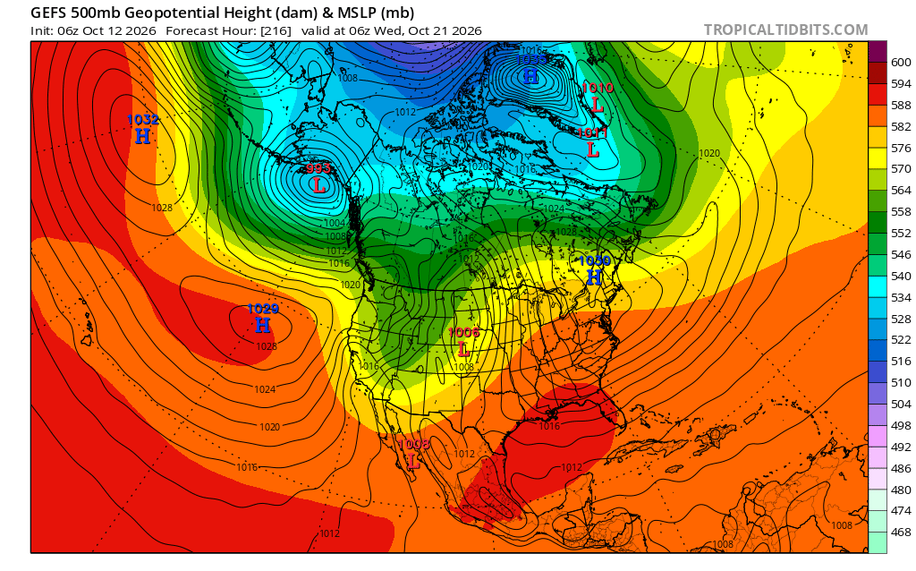
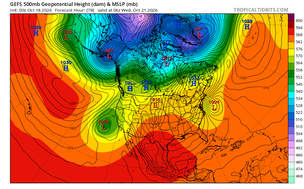
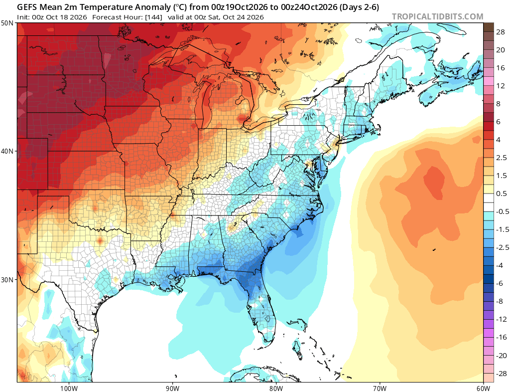
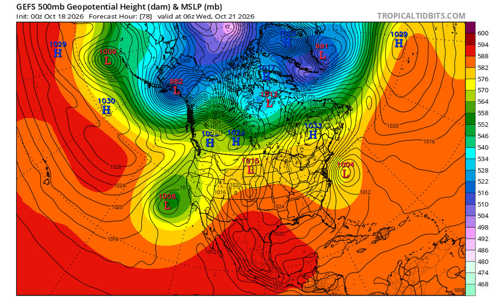
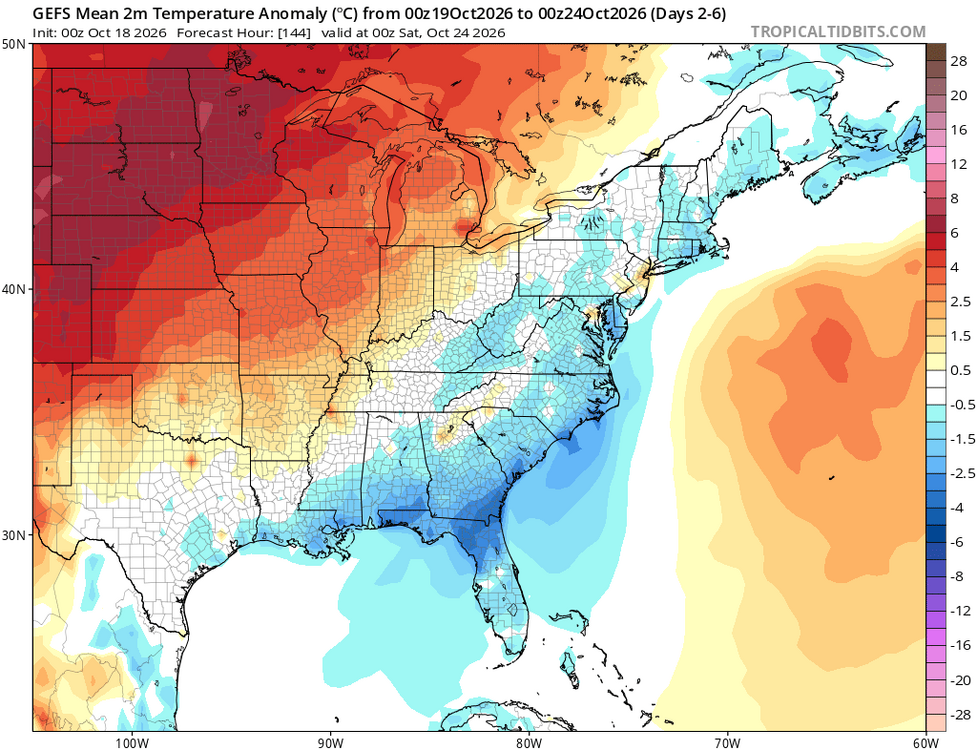
Is the offshore E US strong low bringing down the cool air into the E US this entire week likely related to the very strong Nino? 0Z 10/12 GEFS forecast for 6Z 10/21: no offshore storm and thus no cool air pinned in E US: 0Z 10/18 GEFS forecast for 6Z 10/21: much cooler E US in reality associated with offshore strong storm working in tandem with 3 Canadian highs keeping cool dry Canadian air pinned in E US: Cool air this week E US thanks to the above pattern consistent with Euro Weeklies’ significantly cooler change: (had been warm on runs from Oct 12-13 when no offshore storm)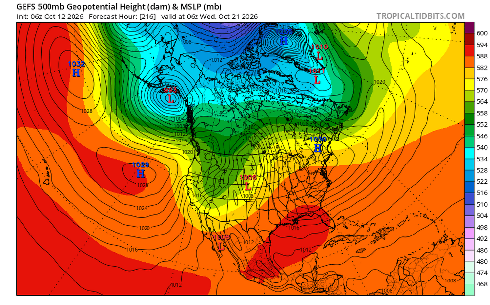
-
For now sure. But once the STJ goes off the scale it’s going to get very wet. December and January likely over 5” each. .
-
2026-2027 Record-breaking El Nino
Typhoon Tip replied to Stormchaserchuck1's topic in Weather Forecasting and Discussion
Yeah...maybe. Don't know. Parsing out the momentum like that over years - that's harder ( at least for me ) to balance sheet that because circulation modes get seasonally mutilated by winter and summer for one. But, the 2023 spring planetary temperature explosion phenomenon is super-climatological in nature and really appears to have taken place mutually exclusive of the ENSO cycling. We need to bear in mind that the sea system and the atmospheric system, en masse, burst .5 C upward in all dimensions, all at once. That in and of itself is still not very satisfyingly explained ...though there are some compelling ideas. sure. But anyway, that took place prior to the end of a cool ENSO, and a couple months before the onset of an ... interim warm phase that frankly I feel was some sort of "absorption event" to try and eat that heat and didn't reflect a truer Nino atmospheric circulation mode outside of the immediate tropics...maybe lower subtropical bands... but that's farmer John's supposition. Anyway, detonating an entire planet like that doesn't lend to stable predictions. -
We could use the break since the last month and change have been rather wet. Nearly 5" at my station for the last 31 days. At least I can keep the sprinklers on a bit longer with the projected AN temps into November. I wonder what the chances are that NYC doesn't see a freeze until December at this point.
-
 We’ll see if we can get a PV split to shake out in our favor. Like I have been saying the Arctic isn’t totally cooked right now, so cold air will be lurking. That’s why I’m excited for this winter, I think it has some real surprises in store. Plus from a pure weather perspective, the STJ amped storms will be interesting in their own right even if they are mainly rain. .
-
happy fall..yall. 37 noted on digi car thermo w/ spotty frost noted on travel to work this am. 35 was lowest seen in my normal cold spot. decent amount of roofs and shaded lawns had frost on shaded north and west facing. Some mesquitos likely did not make it, but id say not hard enough to wipe em out. Just enjoying fall, while we likely have to wait a while for decent winter weather. All good.
-
Low of 30 according to nearest PWS. Very frosty again.
-
Low of 34 again, with some patchy frost
-

2026-2027 Record-breaking El Nino
40/70 Benchmark replied to Stormchaserchuck1's topic in Weather Forecasting and Discussion
Yea, right.......but even considering that logic, you would think that there would be some additional give relative to 2023, whereas that former regime even more deeply entrenched....I mean, El Nino is stronger...PDO is less negative and the warm pool is further east. This is why I believe there is more wiggle room for a window later in the season. -
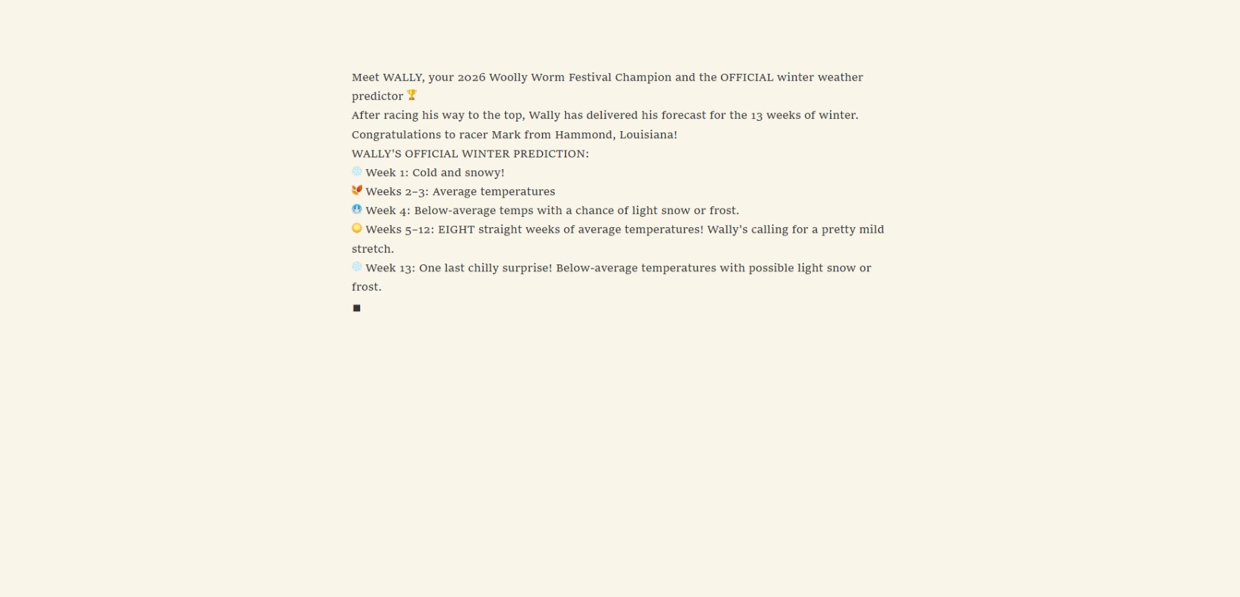
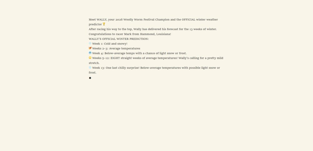
I was at the Woolly Worm Festival this weekend and here it is-----
-
2026-2027 Fall/Winter Mountain Thread
Met1985 replied to BlueRidgeFolklore's topic in Southeastern States
29 degrees again here this morning with a heavy frost.