All Activity
- Past hour
-
Solid lightning show here
-

2026-2027 Strong El Nino
40/70 Benchmark replied to Stormchaserchuck1's topic in Weather Forecasting and Discussion
Yup...this is why I have theorized that we actually want a RONI equal to, or exceeding the ONI. The lagging RONI is indicative of competing cool ENSO AAM. This point it what was lost on me in 2015 and 2023. -

2026-2027 Strong El Nino
LakePaste25 replied to Stormchaserchuck1's topic in Weather Forecasting and Discussion
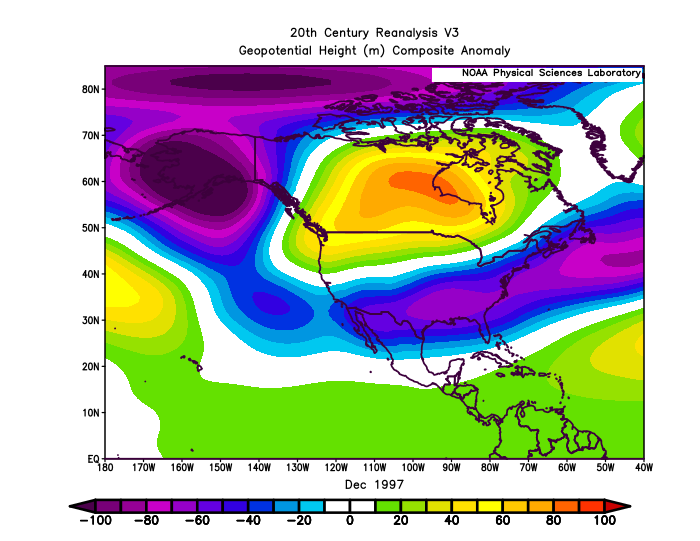
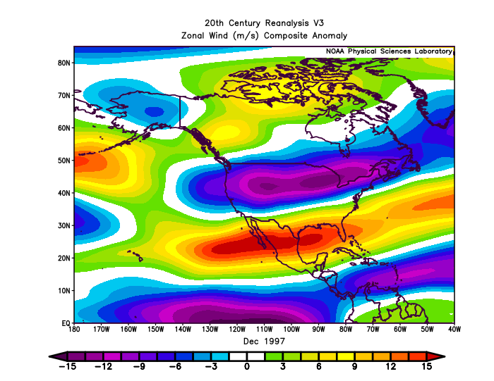
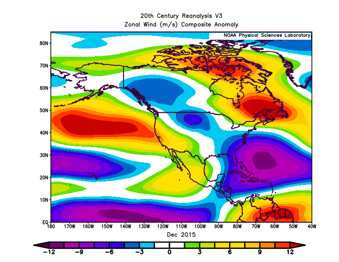
I think when you look at December 2015 alone, it was an anomalous configuration for a super Nino. The lack of a strong southern stream in the SE US allowed storms to cut, so you had both this bad combo of a pac jet extension to the west coast combined with a Nina-like SE ridge configuration. Compare this to December 1997 where you have a strong southern stream extending all the way across the southern US, which is the more canonical Nino outcome. Just giving 1 example of how we can do better than 15-16.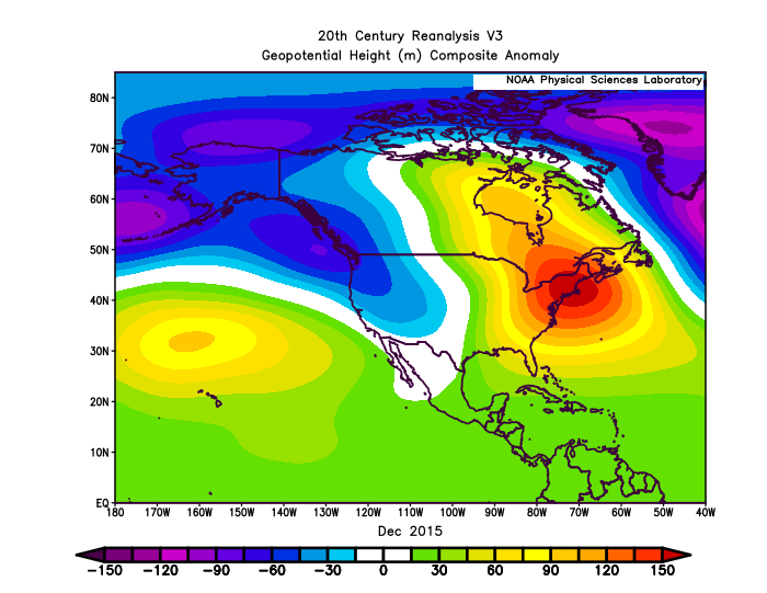
-

BEST CAMERA for photographing?
rygar replied to cyclogenesis's topic in Outdoor and Weather Photography
It all comes down to your budget. If it is 20K you can have the best of the best. If it is $500-$1,000 you can get a lot of great shots in bright light but struggle in the mornings and evenings. With any modern camera you can get fantastic shots. In my experience, the hit rate goes up the more you spend. -
April 30 2004: After a high temperature of 91 on the previous day in the Twin Cities, the mercury tumbles to 47 degrees by the morning. St. Cloud sheds 50 degrees over 12 hours. 1967: Tornadoes hit southern Minnesota. Some of the towns affected were Albert Lea, Waseca, Wells, and Owatonna. For Thursday, April 30, 2026 1852 - A tornado, following the same track as the famous "Tri-state Tornado" of 1925, struck the town of New Harmony IND. Just sixteen persons were killed by the twister, due to the sparse settlement. The "Tri-state Tornado" killed 695 persons. (David Ludlum) 1953 - A tornado 300 yards in width leveled homes on the north side of Warner-Robins GA, and barracks on the south side of the Warner-Robins Air Force Base. (The Weather Channel) 1987 - Thunderstorms developing along a cold front produced severe weather in Idaho, Utah, Wyoming and Montana. Thunderstorms produced wind gusts to 100 mph in Lincoln, Mineral and Sanders counties. Twenty-three cities in the central and southeastern U.S. reported record high temperatures for the date. Memphis TN was the hot spot in the nation with a record high of 94 degrees. (The National Weather Summary) (Storm Data) 1988 - A cold front produced high winds in the southwestern U.S. Winds gusting to 90 mph in southwestern Utah downed power lines, and damaged trees and outbuildings. The high winds also downed power lines in Nevada, completely knocking out power in the town of Henderson. (The National Weather Summary) (Storm Data) 1989 - Thunderstorms produced severe weather in central and eastern Texas. Hail three inches in diameter was reported at Cool, and thunderstorm winds gusted to 80 mph at Hillsboro. For the first time of record Oklahoma City went through the entire month of April without a single thunderstorm. (The National Weather Summary) (Storm Data) (The Weather Channel) 1990 - Late afternoon and evening thunderstorms produced severe weather in southern Virginia and the Carolinas, with tennis ball size hail reported southeast of Chesnee SC. Thunderstorms moving over the Chesapeake Bay flooded U.S. Highway 50 on Kent Island MD with several inches of water resulting in a seventeen-mile long traffic jam. (The National Weather Summary) (Storm Data)
-
How does this spring rank on LI? Do you have stats for Farmingdale?
-
2026-2027 Strong El Nino
40/70 Benchmark replied to Stormchaserchuck1's topic in Weather Forecasting and Discussion
Yea, all of the strong El Nino events that worked out in terms of an active east coast winter had a pronounced period of NAO blocking...only real argument to be made is 2002, but that is significantly weaker than this event should be. -
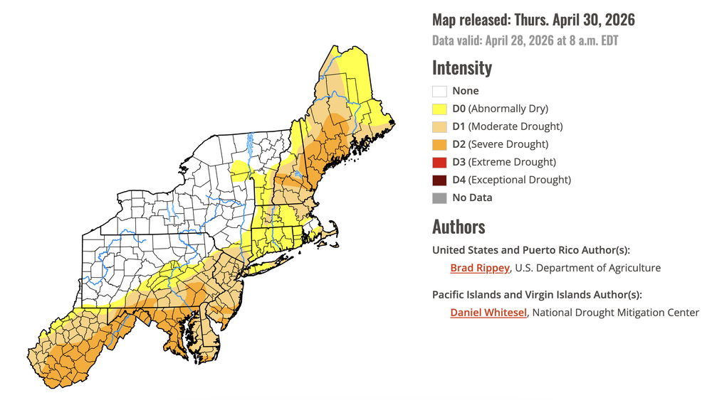
Extreme drought exploded in NC this week. Exceptional drought has developed east of Charlotte: https://droughtmonitor.unl.edu/CurrentMap/StateDroughtMonitor.aspx?NC Hopefully this is the peak
-
What i observed in Raleigh last night as we actually got a thunderstorm for once this spring:
-
Not looking good triad/foothills/mountains
-

2026-2027 Strong El Nino
PhiEaglesfan712 replied to Stormchaserchuck1's topic in Weather Forecasting and Discussion
It all comes down to the blocking pattern. Not all strong el ninos are duds. If we get a blocking pattern like 2009-10, then we may just get a very good winter. However, if we get a blocking pattern (or lack thereof) like 2015-16 or 2023-24, then we're more than likely going to get a torch. -
2026-2027 Strong El Nino
40/70 Benchmark replied to Stormchaserchuck1's topic in Weather Forecasting and Discussion
I haven't see any literature supporting a 2-3 month lag. -
Sorry teacher for being late but ... A grade of A from me. Three months of well below normal temps, a 12" snow/ice storm, a 23" blizzard with 54" season total...long lasting snow cover. Not really counting March in my grade but was disappointed that the season ended that way .
-
March here was +1.8. April will finish at +1.1. Since 1999, April has averaged 44% of available sunshine. April 2026 will have exactly the same. Precip will finish about 1/2" BN - we're at 0.5"-0.6" from the current event and the best is past. Yesterday's forecast of 1-2" for today was optimistic. Month is finishing close to normal.
-
Things better turn around in May-June or we are gonna be baked this summer.
-
So all that hype about the washout type storm and it has all shifted south. Another bust of a forecast capping off a terrible winter season.
-
Looked like we only got about another 0.10 overnight , so about 0.60 for the event. Not bad really.
-
No wine. Ya might be able to understand it if it was wine. He’s just completely wrong….period. Always on the wrong side of everything, all the time.
-
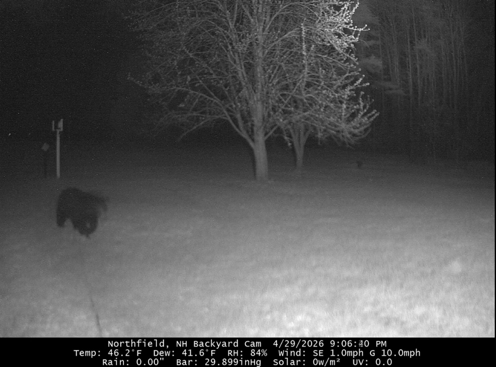
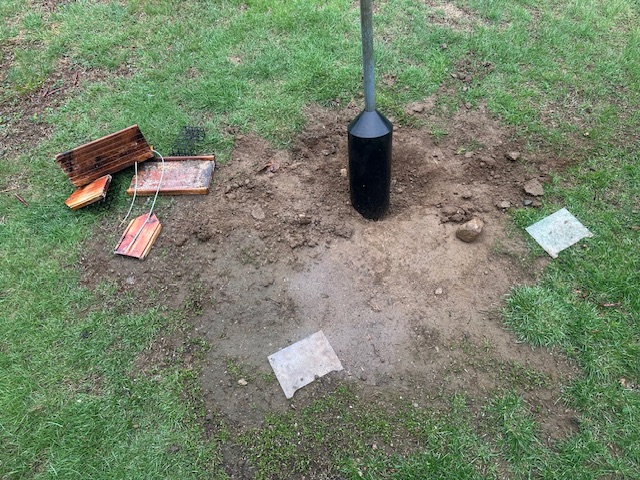
Had a visitor last night

-
I’ve already had 5 on me and 2 latched on. All deer ticks. No rings around the bites yet.
-

2026-2027 Strong El Nino
bluewave replied to Stormchaserchuck1's topic in Weather Forecasting and Discussion
Yeah, late November SSW didn’t translate into weaker Northern Stream until late January and especially February. This allowed the STJ to lead more allowing the KU BM event in late February. But the effect quickly wore off in March and we reverted to the 2020s mean of warm and snowless Marches with a dominant Northern Stream. Plus the NAO has been swinging more from one extreme to the other over time. So we weren’t able to get the extended November to May -NAO of 1995-1996. Several overlapping warming influences working against a 1995-1996 repeat. Especially the overpowering ridge in the Southwest resulting in the 2nd warmest winter for the CONUS. - Today
-
 May DCA NYC BOS ORD ATL IAH DEN PHX SEA -1.0 -0.8 -0.3 -1.0 -0.1 0.0 +0.5 +0.7 +2.5
 -
0.58" for the event ... Drought goes on with another well below normal month here at 2.50".
-
Why do I hate ticks? One mid-range (pinhead size) deer tick latched onto my right lower eyelid last evening, within 1/16" of the top edge. After numerous tries I extracted the little horror, but the eyelid is nicely puffed up. The bit of pain with each blink reminds me just how much I despise the critters.
-
We need a last minute North trend