All Activity
- Past hour
-
I see we have reached the old "well i ain't doing shit because/until all these other places start doing shit' excuse. I don't know about you all but i don't let my property go to crap because my neighbor lets his get unsightly. Usually you double down and keep your place extra tidy to hopefully shame/embarrass the neighbor into doing the same. That's what needs to happen on global scale. Probably won't matter at this point anyway but at least we say we went down swinging. For those who dismiss CC or are not convinced of it, I might have good news. Depending on how oceanic currents break down and where one resides on the planet, your climate might actually get better....for a while. Maybe you dislike winter cold or you live in a rainy area that might dry out or a dry area might become more moist. A rare case where you get the lemonade and then you get the lemons.
-
From World Climate Service (@WorldClimateSvc on X): 4 of the past 5 winters have seen La Niña, and 4 very different outcomes have occurred: - 2020-21: cold south - 2021-22: cold north - 2022-23: cold west - 2024-25: cold east
-
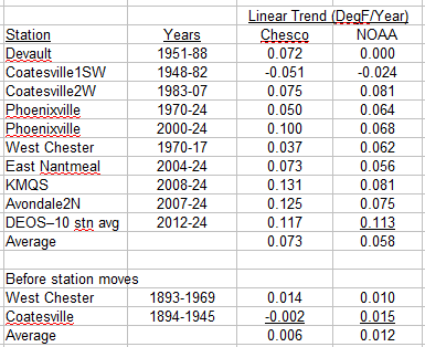
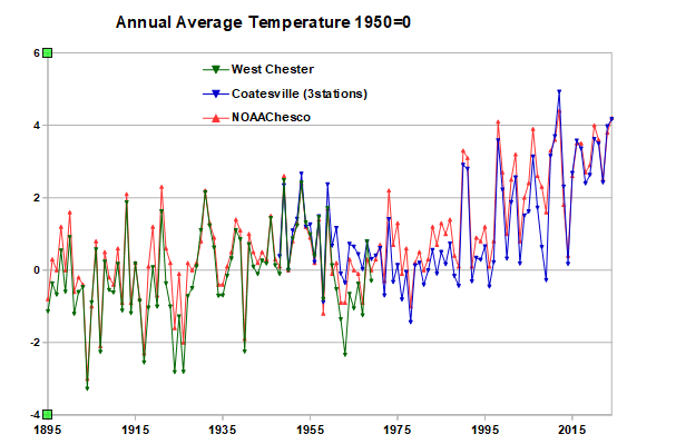
The only adjustment to the West Chester and Coatesville raw data is to take out the temperature difference between the two stations by setting 1950 to zero. The year-to-year change in temperature is exactly what the raw data shows at Coatesville and West Chester. A little over 4F warming between 1894 and present, the same as NOAA. Like I said above you are not even close to what the raw data is showing. Below is a comparison of individual stations to NOAA, excluding station moves of course. The agreement is very good both recently and before the major station moves.. If anything NOAA is underestimating the recent warming in Chester County. Why don't you provide the equivalent trend values for your Chesco average so we can see how you stack up.
-
 Those spring nor’easter events were weak compared to what we more regularly got in the past. Most of our storms in recent years have been cutters and huggers. It’s why this was the first 45+ mph gust of the year from the northeast at LGA. All the other 45+ mph gusts this year were more westerly.
 -
It gets easier to stagnate the diurnal temperature range in October ... particularly so once in the solar minimum, Nov 8 and beyond. The sloping sun is oblique to cloud coverage and that's not very efficient radiative-thermal modulation with that low incidence.
-

The return of the elusive Nor'easter. Drought buster or bust?
mappy replied to dailylurker's topic in Mid Atlantic
Really? It’s more sun than clouds here -
There are signs that the SPV (which is weak right now) bottoms out in early November then starts to strengthen later on in the month….
-
 We just had 2 nor'easters this past spring (April 11-12 and May 21-22).
 -
We had the same 3° (57/54) on Sept 27 during the 2.64" dump - smallest diurnal range we've had in September, though we've had 2° ranges in some other months and June 3, 2001 had 54/53, our only "onesie". As expected, we had little rain or wind, 0.10" and maybe a "gust" of 10 mph. 90%+ leaf drop here. The big oak is still mostly green and there's a few sugar maples with 50% retention though most of that species is near leafless.
-
What's your question? Is the next cooling cycle beginning??? We don't have complete data for this year or decade yet so let's see!!
-

The return of the elusive Nor'easter. Drought buster or bust?
dailylurker replied to dailylurker's topic in Mid Atlantic
I've learned to add 12-24 hours to a forecast if it calls for clearing, dryer air to move in, colder air to move in. This rule of thumb definitely includes cold air chasing moisture. That one never ever works out in my area. I just ignore those forecast. -
It’s not a difficult question to answer
-
'Kay folks, I am well back from The Ledge at this point. Mammoth got ten inches overnight into today with another 7 on the way today. Thats a major hit for them this early. No reaping needed, Reaper can just enjoy retirement. I feel now, like I just won about 14 billion in the Texas Lottery with no Tax. This is likely going to be a 2022-2023 engulfing for Mammoth, Big Bear and Tahoe and all up and down the entire Sierran Cordillera this winter. In early 2023 Big Bear had snow to 35 FEET on a level and they were frantically hand shoveling snow for the damn chairs to slide through! The snow was at the TOP OF THE PYLONS! BOS will get 600 inches this winter and Washington DC and the entire sub will get 70 to 140 inches by late April 2026. PSU and Tracker won't even be able to get out of the damn house.. Forget the thrash metal. Let's get this puppy started! Blast this at 400 decibels. Wake the neighbors up! DC Region is going 2009-2010 / 2013-2014 Hybrid this season could even have a side of 1996 thrown in for good measure! The entire sub will attain full zombiehood this winter from staring at models for months and getting NAM'MED over and over and over and over again! It's gonnabe hunchback Nation from digging too much snow and numerous cases of brokeback from being cooped up for far too long with Ravensrule. (Not that it wouldn't be a thrill, though.) There's NO Panic in DC this Winter.
-

The return of the elusive Nor'easter. Drought buster or bust?
87storms replied to dailylurker's topic in Mid Atlantic
The important thing is that it’s completely overcast rn. Hopefully the sun returns tomorrow. -
As always zero support for the post hoc cooling adjustments for 89 straight years....and now overall warming adjustment to recent years.
-
That climate fence around Chester County PA must be really strong......LOL!
-
Nasty in dighton.
-
 FRG 48, ISP 49 for the highest airport readings. These gusts were right in line with forecasts. FYI that Eatons Neck station is raised, it’s like 90 feet or something like that
 -
wont happen this fall-train/plane schedules (and other things) would need to be adjusted so you'd need more than a 3 week lead time. We also did year round DST in the early 70's, it's lasted one year before reverting back to the prior system
-

2025-2026 ENSO
40/70 Benchmark replied to 40/70 Benchmark's topic in Weather Forecasting and Discussion
I expect to the PV to beef up around the holidays and then we watch and wait for a January-February SSW. - Today
-
yes, aside from the prolonged rain along the shore, it was tame in comparison.
-
Not even close to being right. You are cherry-picking the data you like, the temperature values, and ignoring the rest of the information associated with the raw data: the station locations, the station moves, and the relative temperature between stations. Easy to spot the station moves and other major changes by tracking changes in the relative warmth of the Chesco stations. Its well proven science. That's why NOAA's results are different than yours. I get very similar results to NOAA by using the raw data at West Chester (before move) and Coatesville (after move) and avoiding the station moves. We saw in the other thread that the individual station data agrees with NOAA. Why wouldn't it? NOAA uses all the information and well proven science.
-
You live in a colder area west of I-95 than NYC and other warmer coastal areas. So in marginal storms when the I-95 corridor and points east change to rain your area can remain mostly snow. NYC and coastal sections haven’t reached average mid 20s seasonal snowfall without at least one KU event since the 1990s. Prior to the 1990s NYC and the coastal sections were cold enough to reach mid 20s seasonal snowfall with a bunch of small to moderate events. Hopefully, we can see at least an intermittent return to KU benchmark tracks over the remainder of the 2020s so NYC can have a shot at reaching average snowfall or better.
-

Central PA Fall Discussions and Obs
Itstrainingtime replied to ChescoWx's topic in Upstate New York/Pennsylvania
I am so ready for a wintry scene outside. Beggars can't be choosy but since I'm not begging I'll elect to choose a nice, solid snow cover from late December that lasts into the beginning of 2026. Give me a white landscape for a few weeks during minimal sun angle with long nights and I'd be happy as a fiddle. -
Nah they can be stronger inland and have more precip. This one was primarily far eastern and srn areas.


(002).thumb.png.6e3d9d46bca5fe41aab7a74871dd8af8.png)


