All Activity
- Past hour
-
31" in Seekonk
-
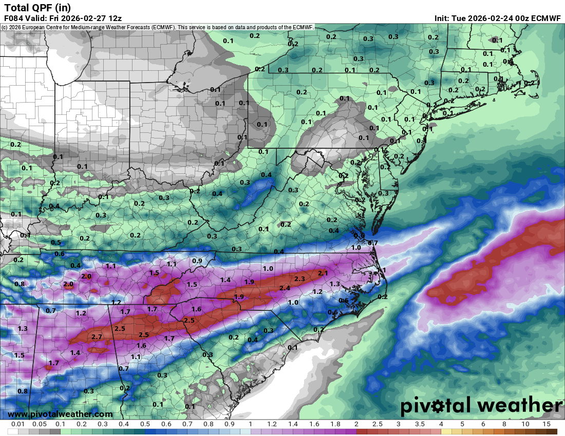
I thought wx models did well at range w/ yesterday's NW flow potential. They kind of hiccuped within 72 hours, but eventually reality would match those prolonged upslope runs from a week ago.
-
PVD is showing 35.5" for 2/23 and 6.7" for 2/22. That's 42.2" for those counting at home. I'm not sure if this is correct yet, but thats what the two daily CLI summaries show right now. edit: I'm an idiot, that was monthly total on 2/22....yeah they are still 37,9 as CLI on 2/22 was 2.4
-
Imo we just had a winter as good as 2010. Their wasn't much winter that winter. Just big snows that melted within a week or so. Those were fun storms but I had more fun this winter.
-
New way to cap the season here. We had light snow falling for almost 24 hours. The snow didn't accumulate much as John noted. Last evening about 8:30, it did pick up and coat everything w/ 0.25-0.4" of powder. Schools were on delay or closed today in much of NE TN. I suspect we get 1-2 more cold shots, but for now....the rain/snow line looks like it is over the Ohio River Valley. But this is the time of year where wx models can change wildly at times. Anything is possible.
-

"Don’t do it" 2026 Blizzard obs, updates and pictures.
ORH_wxman replied to Ginx snewx's topic in New England
Yo, Midlo in the house....thanks man. My front yard looks like yours usually does now. -
This thread went over well like a fart in church
-
Good. Bring the torch. I'm ready for 60s
-

Pittsburgh/Western PA WINTER ‘25/‘26
EVLINC64 replied to Burghblizz's topic in Upstate New York/Pennsylvania
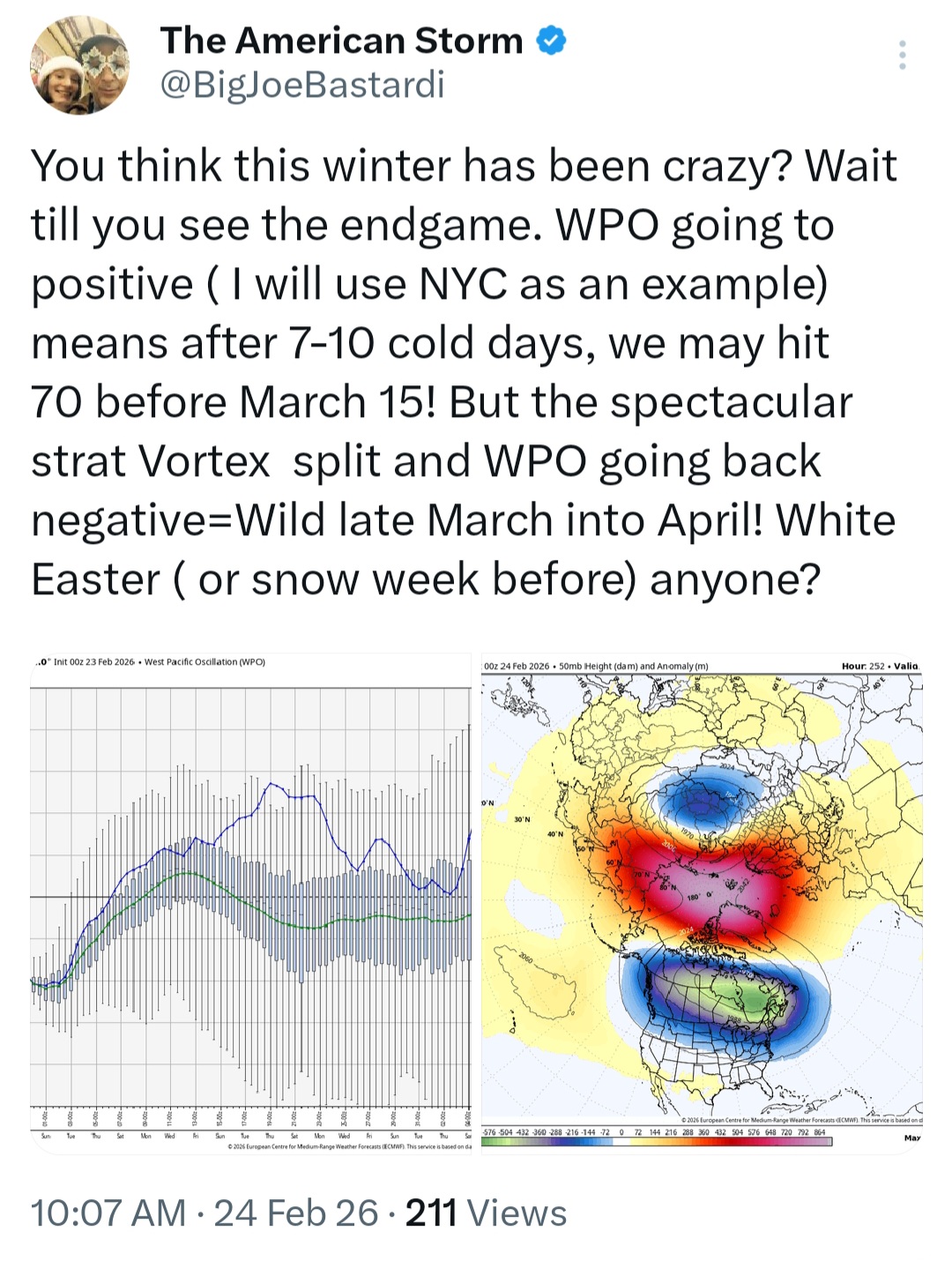
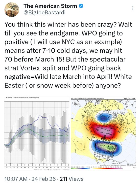
The American Storm @BigJoeBastardi · 13m You think this winter has been crazy? Wait till you see the endgame. WPO going to positive ( I will use NYC as an example) means after 7-10 cold days, we may hit 70 before March 15! But the spectacular strat Vortex split and WPO going back negative=Wild late March into April! White Easter ( or snow week before) anyone? The American Storm @BigJoeBastardi · 11m Only 3 cases of that kind of split around March 10, 2018, 2013, and 1984. All had very cold March 16-April 14. In addition this winter LOOKS LIKE THE BLEND OF 1933-1934 95-96. Cold came roaring back then too -
do you think we'll ever get a winter as good or better than 2009-10, or did literally everything go right with that season?
-
I mean, there' always way for torches to fail here in this time of year, even if it "verifies" And by "verifies", i mean it actually ends up AN, but the pretty colors at 850 and 500 are way underpeforming at the sfc with CAD systems or light onshore flow. A 60F torching cutter turns into a cold 37F rain or even ice/rain.
-
If by “horrible” you mean cool spring in the E US, good! Bring it on as I love it way down here! Actually cool late Mar/early April here means highs mainly 60-75 and lows 40-50 along with nice low dewpoints for great outdoor wx.
-
Ehhh around 3/15 more likely
-
Given the cold shelf waters, it will be a battle this spring to get any nice weather outside of a random day here and there
-
Great post, thank you. We’ll keep an eye on how the nino develops and how much it strengthens. I don’t know how we will end up categorizing the type, but I don’t think we go higher than moderate based on RONI.
-

Central PA Winter 25/26 Discussion and Obs
anotherman replied to MAG5035's topic in Upstate New York/Pennsylvania
Yeah, 2027 looks unlikely…. -
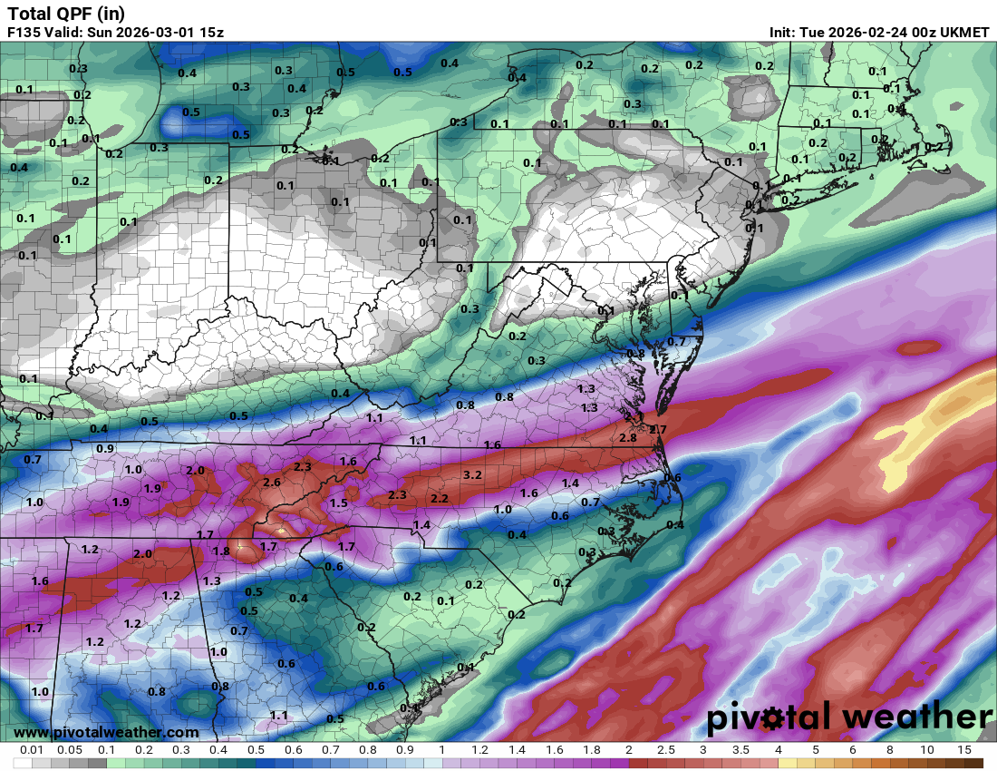
Next bit of interesting weather is some training of heavy rain cells Thurs/Friday that could lead to flash flooding concerns over a narrow stripe

-
-

"Don’t do it" 2026 Blizzard obs, updates and pictures.
OceanStWx replied to Ginx snewx's topic in New England
In a typical developing (i.e. not peak intensity) storm your frontogenesis is going to be sloped towards the cold air. 850 is farther southeast than 700 mb, and so on. Lift tends to be maximized around 700 mb, hence congrats Dendrite. This storm bombed out a little farther south, so one of the first things I noticed was the position of the forecast 700 and 850 mb frontogenesis. While still sloped a bit, it's far more collocated/vertically stacked. That signaled to me that one major band would develop. And that look at 700 mb with a secondary band farther north suggested to me that it wasn't going to be a uniform precip shield. That a subsidence zone was possible between the two. I may have sent a text about toaster baths in the LWM area to @CoastalWx and @CT Rain Sunday. I made a little gif too, so you can see how the forcing is overlaid. I do think part of the problem with the secondary band was that it was advecting so much dry air into the storm. @dendrite posted somewhere along the line the map of RH, and 50% across central NH just wasn't going to get it done for that northern extent. It was like a dry wedge in the usually CAD spots. -
Horrible Spring ?

-
Exactly.
-
That was an analog by many going into this winter.
-
Awful spring incoming

-

Clipper Fires In Wednesday Feb 25 Disco/ Obs
dryslot replied to Damage In Tolland's topic in New England
2-4" -
Not sure why the BOS and ORH totals are wrong there, but BOS is over 60" now and ORH is actually 75.4" and not 77.5"