All Activity
- Past hour
-

December 2025 Short/Medium Range Forecast Thread
Carvers Gap replied to John1122's topic in Tennessee Valley
Record lows. Seems to be an outlier at 12z, but…it caught the Dec 29th front first. Teens below zero. -
I wasn’t awake then to post about it
-
Merry Christmas!
-

White Christmas Miracle? December 23-24th
SouthCoastMA replied to Baroclinic Zone's topic in New England
@CoastalWxabout to get raked -
Unfortunately the guy who filed with a drone last year isn't around but will have video and pics
-

White Christmas Miracle? December 23-24th
bristolri_wx replied to Baroclinic Zone's topic in New England
LOL Cape Cod getting snow again while RI is getting none. We get it in all directions lol. -
Great event. Trying to tack on another tenth right now with upslope. About 10.5” of depth.
-

Snow Potential Dec 26-27
SomeguyfromTakomaPark replied to WeatherGeek2025's topic in New York City Metro
Soundings around HPN look really good during the late evening, should be decent ratios. -

26th-27th event, coming at us like a wounded duck.
weatherwiz replied to Go Kart Mozart's topic in New England
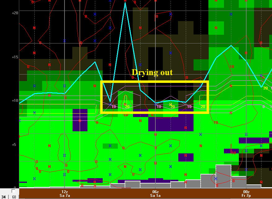
I should add the drier air would probably just hold back accumulation potential. So say if it looked good for 5-6-7"...it may hold it down to more in the 3-5" range. This is BDR. Good solid ~3 hour window for moderate snow then the DGZ goes to crap as drier air works in. I just think this needs to be considered when forecasting the ceiling on this.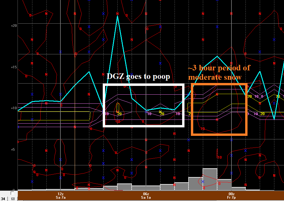
-
They been up since 2am lol
-

E PA/NJ/DE Winter 2025-26 Obs/Discussion
RedSky replied to LVblizzard's topic in Philadelphia Region
Thursday A slight chance of snow before 10am, then a slight chance of rain between 10am and 1pm. Mostly cloudy, with a high near 43. South wind 5 to 10 mph becoming northwest in the afternoon. Chance of precipitation is 20%. Somebody tell Lloyd Christmas there's a chance.. -

2025-2026 ENSO
Stormchaserchuck1 replied to 40/70 Benchmark's topic in Weather Forecasting and Discussion
I bought in at $48! Trying to decide whether to sell today, or hold on a little longer. That $50 mark was a top that held for 50 years when just about every other metal has hit a new all time high, so when it finally passed it, it accelerated. Gold had its 2nd best year since the 1970s in 2025. It has an Up signal for next year, per a method I've backtested.. -
State College NWS has issued watches for all their counties along the M/D line
-

White Christmas Miracle? December 23-24th
Patrick-02540 replied to Baroclinic Zone's topic in New England
Just spoke to my aunt out there. 25-30 steady, 50mph gusts. The poor thing got blown over in a parking lot in Yarmouthport earlier today. Moderate to heavy wet snow right now. -
Snow Potential Dec 26-27
SomeguyfromTakomaPark replied to WeatherGeek2025's topic in New York City Metro
Great map, I think this argues for 4-8 or 6-10 or the lower Hudson valley and 3-6 for nyc. -
Boxing Night Snow/Sleet/Ice Dec 26-27 Storm Thread/Obs.
RedSky replied to Mikeymac5306's topic in Philadelphia Region
Euro didn't change much other then a little dry -
Enjoying the sunshine, but it's a bit toasty.
-
it is so windy i was pushed back by the wind i felt like a little kid again..
-
Sill going, At 17.5" maybe we get to 18"?
.thumb.jpg.fd1551956ea70e710064e7bc19e63323.jpg)
-

White Christmas Miracle? December 23-24th
Great Snow 1717 replied to Baroclinic Zone's topic in New England
Folks look on the bright side, at least New England is avoiding the record breaking torch that is impacting a large part of the country... -
Yeah it hasn't waffled around at all over the past 48+ hours or so. Only thing holding back higher snow totals is the speed. This thing is really hauling. In and out in about 8 hours or so. So yeah 3-6" is a good bet
-
Pretty solid rates for what I was expecting. Mulch and dirt are whitening up for now. I'm sure once it stopes it'll all melt, but for now it's a nice visual.
-

26th-27th event, coming at us like a wounded duck.
TauntonBlizzard2013 replied to Go Kart Mozart's topic in New England
Euro is solid advisory for SW CT. Very little elsehwere -
(002).thumb.png.6e3d9d46bca5fe41aab7a74871dd8af8.png)
Boxing Night Snow/Sleet/Ice Dec 26-27 Storm Thread/Obs.
ChescoWx replied to Mikeymac5306's topic in Philadelphia Region
If only model snow was the real thing!! If I plowed all of the model snow we have not received my snowblower would be in the trash from overuse!! LOL! -
26th-27th event, coming at us like a wounded duck.
weatherwiz replied to Go Kart Mozart's topic in New England
well I think its still an encouraging sign for places basically along a line say from Danbury to Bridgeport to Southbury-Oxford-Seymour. But the challenge with this is this will be a nowcast situation because ultimately its how the storm evolves which will dictate where the heaviest banding occurs. I am not as nervous about the dry air anymore...the dry air will work in behind the slug of precipitation and will probably help to enhance rates within the precipitation shield. What I would be most nervous about is where the strongest push of WAA occurrs. Given how far SW models have that it may be difficult to even get more than 2-3" back outside of southwestern Fairfield County. We're going to have to rely on mesos for this one I think and just hope the models can pick up on it


.jpg.f304be30086b4fba2706cbddf5f3b28f.jpg)

