All Activity
- Past hour
-
 yeah was anyone actually denying upper 50s/low 60s. the only controversial take I saw was "beware of 70"
 -
I consider any accumulation from squalls an overachiever if it's fairly widespread....but yeah, I do think there will be some isolated streamers that get a few lucky peeps. It would be nice if we could turn the low level winds more to the south out ahead of the secondary arctic front. That would help pool a little more moisture.
-
.
-

December 2025 regional war/obs/disco thread
Ginx snewx replied to Torch Tiger's topic in New England
Except not calling for overachiever. -
EPS likes 12/6 for another threat. Then when you loop the individual member plot beyond 12/6, it's kind of like buckshot from 12/8-12/11 which is the end of the run...that tells me its pretty active if sub-1004 lows are appearing that frequently on the ensemble plot. Hopefully that NAO depiction is real....it's the type of orientation we want too....the retrograding Scandinavian ridge instead of some ugly thing from the Azors....that type of -PNA/-NAO look I've mentioned in the past can be pretty prolific here.
-
December 2025 regional war/obs/disco thread
Ginx snewx replied to Torch Tiger's topic in New England
Note the wind shift with a substantial change in windex potential. Not a huge deal but could be some first accumulation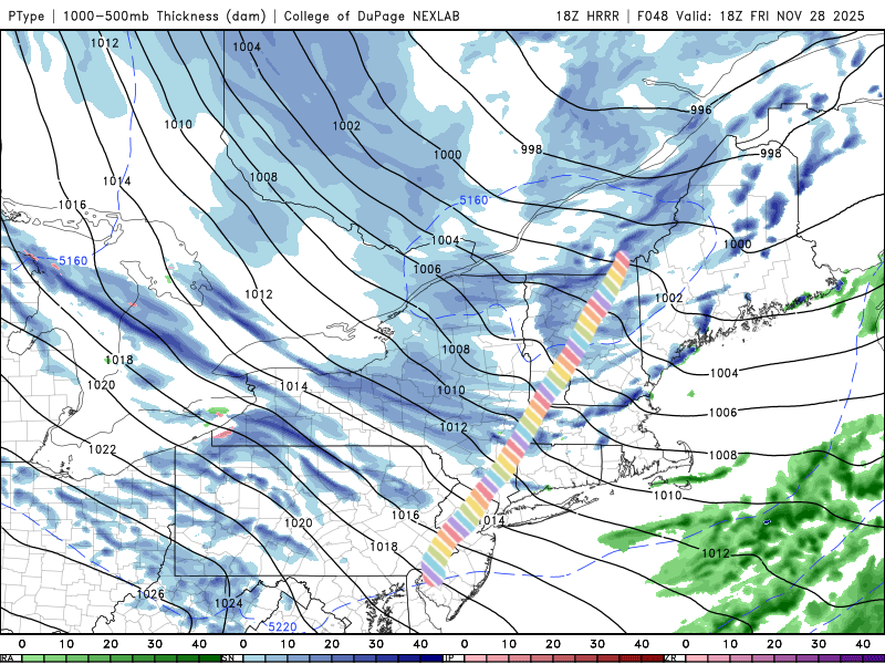
-
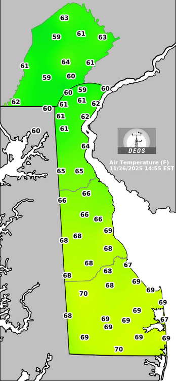
Up to 72 at Dulles. Christmas in Savannah weather.
-

Central PA Fall Discussions and Obs
mahantango#1 replied to ChescoWx's topic in Upstate New York/Pennsylvania
WxRisk FINAL winter 2025-26 Forecast https://tinyurl.com/7tjv83cy -
i can feel the warmth.
-
Not very good low level moisture either which is what you want for over achieving WINDEX events.
-
Hit 70.0 exactly. Really nice out.
-

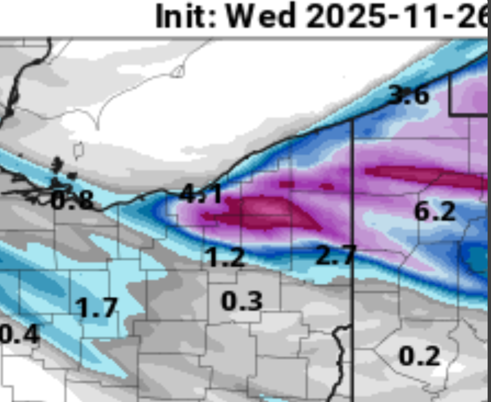
Nov 28-30th Post Turkey Day Wintry Potential
Malacka11 replied to Chicago Storm's topic in Lakes/Ohio Valley
It's either giving bait or ghd2 I can't quite decide -
 High of 58.1 here in EH. I didn't hate it.
 -

Nov 28-30th Post Turkey Day Wintry Potential
ChiTownSnow replied to Chicago Storm's topic in Lakes/Ohio Valley
More of an east to west trajectory and longer duration as a result -

Central PA Fall Discussions and Obs
Jns2183 replied to ChescoWx's topic in Upstate New York/Pennsylvania
So does wind start tonight and go through Friday? Sent from my SM-G970U1 using Tapatalk -

MO/KS/AR/OK 2025-2026 Winter Discussion
stormdragonwx replied to stormdragonwx's topic in Central/Western States
Some high-res models showing potential for some snow flurries for Thanksgiving over parts of NW AR and SW MO. We shall see what happens. Classic winter NW flow pattern. -

November 2025 general discussions and probable topic derailings ...
Lava Rock replied to Typhoon Tip's topic in New England
Someone hit 70? -
HRR runs have a near ideal band out this way.

-
I said slam dunk pattern not slam dunk storm. We usually need pattern recognition first. Its trending away from a SE Ridge for now but there are other complications like the MJO and the Pacific is still not playing nice. Yet.
-
Well surprise surprise. Just got a downpour all be it short. Had 1/4” hail with it. 0.16”.
-
This guy says no. Let's block him!
-
Has it ever looked like a slam dunk for southern snow at this range? C'mon man.... Look at how the pattern has changed in just the last 3 days. Who knows what December will bring. We are definitely heading in the right direction... You have to agree with that.
-

Central PA Fall Discussions and Obs
Blizzard of 93 replied to ChescoWx's topic in Upstate New York/Pennsylvania
Good to see the 12z GFS, Canadian & Euro each showing a winter storm chance for Tuesday at this point. Plenty of time to sort out the details, but it would be great to get on the board so early even if it ends up as a light event: It should be just the beginning of our chances in December.


-

Nov 28-30th Post Turkey Day Wintry Potential
Radtechwxman replied to Chicago Storm's topic in Lakes/Ohio Valley
You watch your mouth. Don't speak it into existence. Lol Low ratios and snow falling during day in marginal temps will definitely lead to a lot of compaction. Going to be heavy wet snow -
Temp is dropping and wind starting to pick up a bit. Down to 44