All Activity
- Past hour
-
I'm moving up to Saugerties this weekend, rip to my legendary radiating hole
-

2025-2026 ENSO
so_whats_happening replied to 40/70 Benchmark's topic in Weather Forecasting and Discussion
I feel like there was a way but maybe that was a different forum I was on. So true though 100+ pages... im not going through that. CDAS almost looks representative to RONI output compared to OISST and CRW. -
Because it's hot? I like it out there, more of a laid back valley lifestyle. Even where you and I are now is kind of connected to the Boston hustle vibe. RT 2 East is packed in the AM.
-
The supposed current heat has not been a factor here. My high today was 80.4, the first day above 80. It was 54 this morning. Chilled the house with the windows open. Haven't had my AC on in almost 30 days now. Basically a late summer miracle.
- Today
-
I liked that area when I worked out there, rather live where I am now.
-
I’m planning to save on heating costs this winter by having no clouds.
-
While we're at it why don't you quantify similar. I'm willing to bet you don't mean less.
-
Got to love this paragraph. If I'm reading it correctly eversource, if temperatures are similar to the warmest 10-year period on the face of the Earth I'm good? "Last winter’s bills were higher in part because the weather was much colder than usual. If this winter’s weather and energy use go back to what's typical over the past 10 years, even with higher rates, we estimate your total bill to be similar to last year."
-
Eversource gas rates going up 13% on November 1st. Good thing we shut down all the solar and nearly completed wind farms. Dendrite please don't give a demerit for a semi-political comment.

- Yesterday
-
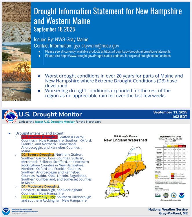
Did pick up 0.11” for a September total so far of 0.28”. Tinder dry.
-
83.8° high off a 46.2° low this morning. Just about perfect weather really. Makes me excited to practice my new fire breathing hobby in the woods out back later this evening.
-
The pattern the next two weeks will support additional cooling in the GOA with warming or at least maintenance of the warmth in the west Pacific. Beyond that who knows. But as others noted, the NE Pacific warm pool did collapse in October 2013 and didn't rebuild all the way until December. Obviously that was the result of the pattern though, rather than the SSTAs driving anything.
-
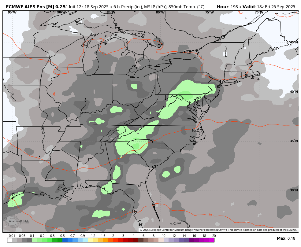
Models are all over the place for late next week but the Euro shows a deluge
.thumb.png.47cff5e5328ea10ed18146d9125eb50a.png)
-

September 2025 OBS-Discussion centered NYC subforum
donsutherland1 replied to wdrag's topic in New York City Metro
Tomorrow will be partly cloudy and unseasonably warm. Temperatures will top out in the lower 80s. The warmer spots could see some middle and perhaps upper 80s. Cooler air will return for the weekend with another warmup possible starting early next week. The ENSO Region 1+2 anomaly was -0.2°C and the Region 3.4 anomaly was -0.5°C for the week centered around September 10. For the past six weeks, the ENSO Region 1+2 anomaly has averaged +0.10°C and the ENSO Region 3.4 anomaly has averaged -0.37°C. La Niña conditions will likely develop during mid- or late-autumn. The SOI was +4.40 today. The preliminary Arctic Oscillation (AO) was -0.972 today. Based on sensitivity analysis applied to the latest guidance, there is an implied near 54% probability that New York City will have a warmer than normal September (1991-2020 normal). September will likely finish with a mean temperature near 69.3° (0.1° above normal). Supplemental Information: The projected mean would be 1.3° above the 1981-2010 normal monthly value. -
I went to the BigE today.. I don't miss living in that area at all ..
-
Well at least as a naked swirl, we can tell it has a closed circulation...... Still a lot of dry air in the area around TS Gabrielle.
-
End of next week looks wet on WB AI ensemble.

-

September 2025 OBS-Discussion centered NYC subforum
SACRUS replied to wdrag's topic in New York City Metro
Records: Highs: EWR: 90 (1992) NYC: 91 (1891) LGA: 89 (1965) JFK: 90 (1965) Lows: EWR: 42 (1937) NYC: 44 (1990) LGA: 49 (1990) JFK: 46 (1961) Historical: 1752: The hurricane of 1752 was one of the most devastating in the history of Charleston, SC. Although the number of fatalities could not be determined, a contemporary Boston press report, based on a ship officer's account, estimated that 95 people drowned. The destruction of trees was severe. One plantation owner's loss was assessed at $50,000. (Ref. AccWeather Weather History) 1816: A tropical storm affected Virginia before moving northeast into New York. Heavy rains caused the James river in Richmond to rise only an inch or two lower than the High Fresh of 1814. Flood waters invaded the first floors of area homes. One bridge was submerged, cutting off travel (Chapman). (Ref. for Tropical Storm of 1816) 1886: A tornado moved along the Des Plaines River in northeast Illinois, hitting the city of Joliet. The tornado destroyed 20 homes, 10 barns, two factories, and a grain elevator; a bridge was moved intact for two blocks. 20 people were injured, but the loud roar of the approaching tornado allowed residents time to take shelter, so no one was killed. (Ref. Wilson Wx. History) 1926 - The great ""Miami Hurricane"" produced winds reaching 138 mph which drove ocean waters into the Biscayne Bay drowning 135 persons. The eye of the hurricane passed over Miami, at which time the barometric pressure reached 27.61 inches. Tides up to twelve feet high accompanied the hurricane, which claimed a total of 372 lives. (David Ludlum) (The Weather Channel) 1933: The September 17th and 18th storm gave 13.27 inches of rain at Provincetown, MA causing severe flooding! (Ref. Notable New England Hurricanes) 1936: A passing hurricane did heavy damage in Salisbury Maryland and gave 4.61 inches of rain in Washington, DC and Baltimore received only a trace of rain. 1936 Hurricane Track - Weather Underground 1941: A remarkable aurora borealis or "northern lights" was observed as far south as north Florida on this night and the 19th. (Ref. Wilson Wx. History) 1971: A brush fire at Lake Alexander, MN in Morrison County started a 10-foot wide, 50-foot high "fire whirl." It moved out over the lake, overturned a 1,800 pound pontoon boat, and then dissipated as it moved back to shore. (Ref. AccWeather Weather History) 1950: Hail covered the ground to a depth of 2 inches at Phoenix, AZ. Damage was extensive at the airport, where 22 planes were destroyed. (Ref. Wilson Wx. History) 1978: Parts of the northern Rockies received some early season snow. 21 inches of snow fell at Red Lodge, MT reported 21 inches. Lesser amounts fell at lower elevations. Joliet, MT received 1.5 inches and Billings, MT received a trace. (Ref. Wilson Wx. History) 1987 - Early morning thunderstorms in northern Texas produced wind gusts to 65 mph at Sulphur Springs, and 2.50 inches of rain in one hour at Commerce, which caused widespread street flooding. Bonham TX received 4.50 inches of rain which also resulted in widespread street flooding as Pig Branch overflowed its banks. (Storm Data) (The National Weather Summary) 1988 - A strong cold front produced severe thunderstorms in the north central U.S. High winds behind the cold front gusted to 92 mph at Fort Collins CO, and up to a foot of snow blanketed the mountains of Montana, with seven inches reported at Great Falls. High winds in Colorado caused three million dollars damage. (Storm Data) (The National Weather Summary) 1989 - Hurricane Hugo hit Puerto Rico, producing wind gusts to 92 mph at San Juan, and wind gusts to 120 mph at Roosevelt Roads. Hugo produced a storm surge of four to six feet, and northeastern sections of the island were deluged with more than ten inches of rain. Hugo claimed the lives of a dozen persons in Puerto Rico, and caused a bilion dollars damage, including 100 million dollars damage to crops. Thunderstorms representing what remained of Hurricane Octave continued to bring heavy rain to the valleys of northern California. Heavier 24 hour rainfall totals included 3.15 inches at Redding, and 2.66 inches at Red Bluff. (The National Weather Summary) (Storm Data) 1991: 2.4 inches of snow fell at Duluth, MN to set not only a new record daily snowfall but also a new record total for September. The previous record snowfall for September was 1.5 inches set back in 1908. (Ref. AccWeather Weather History) 2003: Hurricane Isabel made landfall along the Outer Banks of North Carolina with maximum sustained winds near 100 mph and a minimum central pressure of 956 millibars or 28.23 inches of mercury. The greatest impacts were felt in North Carolina and Virginia. Hurricane Isabel gave Annandale - Barcroft Hills Weather Center a 41 mph wind gust today at 1603 which was the highest wind ever recorded for September at this station. -
-
Low of 62, high of 81. Dew point climbed to 70 today so it did feel a bit more humid.
-
You have a special room in the basement for that
-
.92 at since 8/1 at the closest station to me. https://www.wunderground.com/dashboard/pws/KVTNORWI10/graph/2025-07-1/2025-07-1/monthly 1.76 since we had a big storm on 7/10.
-

September 2025 OBS-Discussion centered NYC subforum
uofmiami replied to wdrag's topic in New York City Metro
81.3 in Muttontown & 81.1 in Syosset for the high. -
Summer's last gasp coming up this weekend and next week? I think so. LR ext modeling and general ensembles depict BN heights dropping into the Aleutians. That should pop a ridge out West, and goodbye summer heat. But before we get there, it is gonna get HOT. Early October should feature a full blown transition to generally normal to BN temps.
-
We moist here. 3” MTD for a lot of the area.


.thumb.JPG.418e8a9a2902ae687ec35ff4bc0e038e.JPG)


.png.23664c24952c9d3db0c04fe7bfd62fa3.png)