All Activity
- Past hour
-

January 24-26: Miracle or Mirage JV/Banter Thread!
Wxtrix replied to SnowenOutThere's topic in Mid Atlantic
not clskinsfan but here in the EP: the Hampton Inn just outside town has good reviews, and you can walk to restaurants and a grocery store. we've stayed in Hilton Home2 Suites elsewhere and they have kitchens. it's in the same shopping center as the Hampton Inn. there's an inn in town and you can walk to restaurants and our locally-sourced grocery store but I don't know what will actually open on Sunday/Monday. but there will be great photo ops of the old part of town. my husband is recovering from emergency surgery (a great Christmas!! not) and is doing well, so we can't have guests right now. and of course the storm could shift away from us too. -
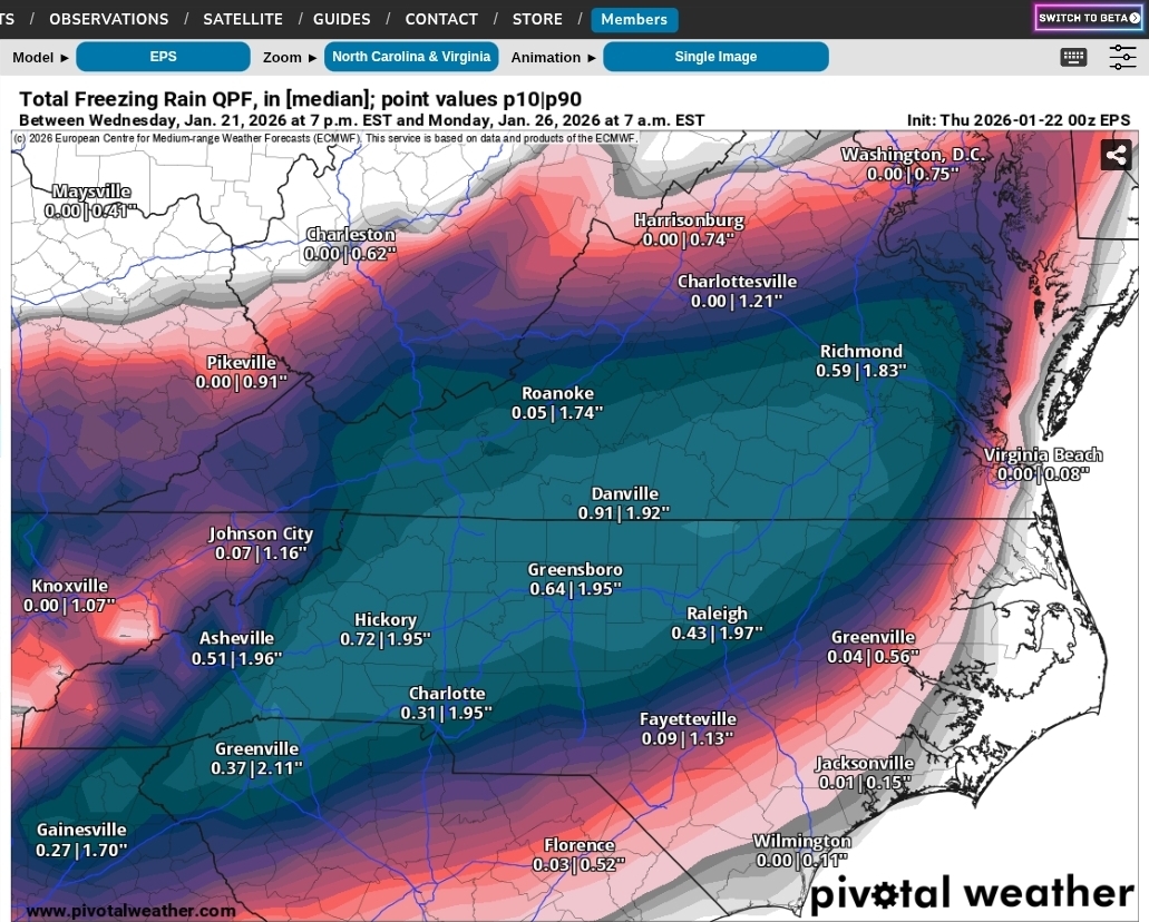
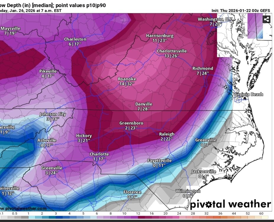
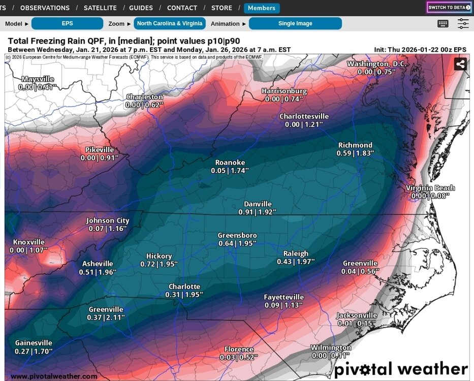
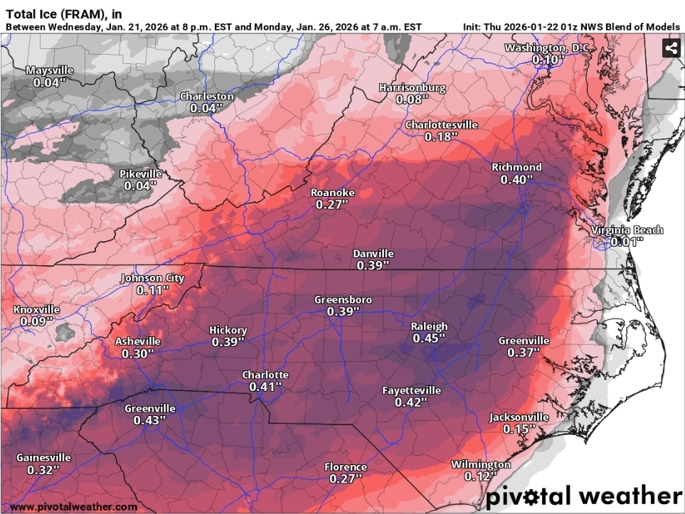
930pm evening AFD update snippet One thing to note regarding this evening`s guidance is that there has been a northern and western push which favors wintry mix across southern MD and central VA. The uncertainty remains in how far north this mix line evolves given the track of system whether it`s further to west or south of the region. The ECMWF, ICON, GFS, GEM, GEFS, and EPS illustrate this in different variations with a the highest probabilities of ice (i.e., sleet/some freezing rain) in the aformentioned areas above. Each of these solutions do have a variation of sleet mixing with snow and making it as far north as the I-95 corridor as the system kicks out Sunday afternoon. The probability of 0.01" of ice remains between 10 to 20 percent along I-66/US-50 and into I-95 north and east of DC. These values jump up to 25 to 35 percent across southern MD and central VA where slightly warmer air aloft/dry slotting may win out. The probabilities for significant/impactful snow have not changed a whole lot with the entire area seeing 65 to 85 percent probs of 6 to 8 inches snow. These probabilities drop down to 35 to 60 percent for a foot of snow, especially in the climo favored zones along and west of I-95 as well as down into northern Shenandoah Valley/Allegheny Mountains. This signal has trended upward in the last few runs, especially on the ECMWF/ECS as well as GEPS compared to the GEFS which focus this axis a bit further south. Of course these numbers will go up or down based upon any mixing that may occur. Snow to liquid ratios look to start around 15:1 with this system for the entirety of the area, while then trending down toward 10:1 and perhaps slightly lower Sunday morning into the afternoon as some mixing occurs. The pending dry slot could also play into this as well. Snow should be fluffy in nature, particularly within the initial warm advection conveyor belt. Expect some crustiness of this snowpack given any mixing that may occur as the system kicks out during the second half of Sunday. Now is the time for the public to make preparations for the storm. This includes getting any necessary groceries or medicines that you may not be able to access this weekend into early next week due to any potential closure. Have an emergency kit in the car including extra batteries, a flashlight, and blanket just in case you get stranded. Make sure to refuel your car before the storm hits. Check on elederly friends/neighbors and don`t forget about your pets during this prolonged cold period.
-
Liking 2-5” locally.
-
I WOULD say bring it - we have plenty of space - but being in the BR, I can't guarantee that you'll be able to get out before Tues or maybe even Wed. In 2016 it took them 3 days to get to us with large bulldozers driving down the middle of the road. Dump trucks couldn't push it.
-
Well since we have so many people on here that ride the euro we might as well start it because its showing it. .
-

“Cory’s in LA! Let’s MECS!” Jan. 24-26 Disco
H2Otown_WX replied to TheSnowman's topic in New England
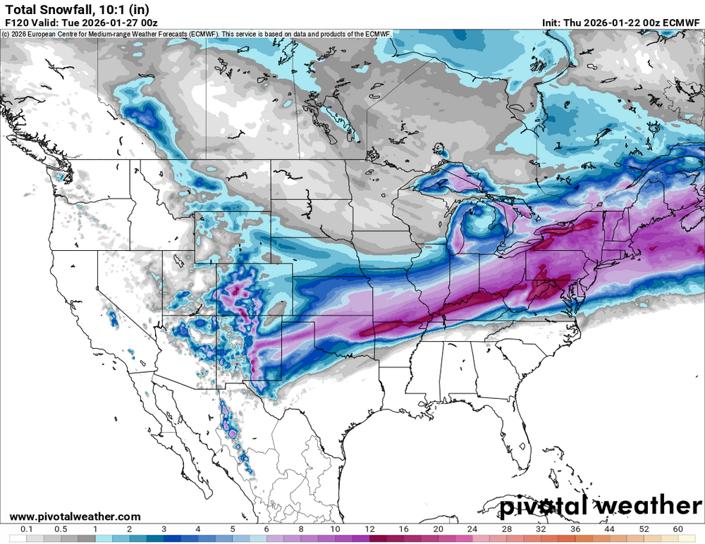
Damn that is some pure wx porn right there. Does anyone have an idea what the ceiling is on this? Could we slowly see QPF bump up as we get closer? I was thinking with this much moisture we could see some 1.5"+ runs which if we get 15 or 20:1 ratios opens up the possibility of a HECS -
I'm gathering this was posted already... but LWX says SLRs to start at 15:1 for the entire region in their AFD
-

Richmond Metro/Hampton Roads Area Discussion
chris624wx replied to RIC Airport's topic in Mid Atlantic
00z Euro has an absolute Miller A coastal low for the next threat this run! -
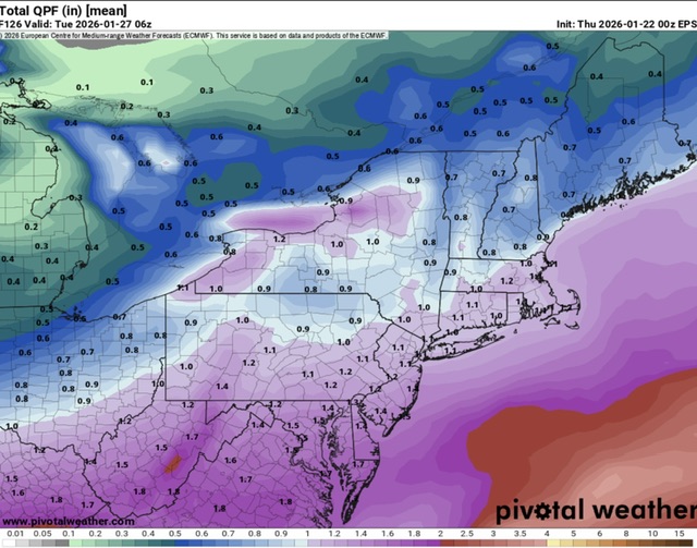
Latest ensembles. Certainly still showing impressive qpf. Not sure what's keeping Wakefield from housting WSW.

-
Now I know why I woke up and cant sleep.. 0z was amazing hope it continues!!!
-

“Cory’s in LA! Let’s MECS!” Jan. 24-26 Disco
Ginx snewx replied to TheSnowman's topic in New England
Then the Son of Sam blizzard that would be epic. -
More ensembles

-
Huge snow swath. Starts right on the continental divide in New Mexico and goes all the way past eastern Maine
-

Possible Record Breaking Cold + Snow Sunday 1/25 - Tuesday 1/27
Prue11 replied to TriPol's topic in New York City Metro
We had over 2’ in 12 hours February 2013 in Suffolk -
Oy.

-

Possible Record Breaking Cold + Snow Sunday 1/25 - Tuesday 1/27
Snowlover11 replied to TriPol's topic in New York City Metro
Correct usually 48 hrs in advance. -
31.6/29 S- 3.3"
-
0z eps looks good to me. Really not too different. A bit more qpf.
-
Yeah, I glanced at it too quckly. Sometimes foot in mouth disease is a thing...
-
You’re welcome
-
Thank you
-

E PA/NJ/DE Winter 2025-26 Obs/Discussion
RedSky replied to LVblizzard's topic in Philadelphia Region
0z ECM has the second snow storm the GFS lost -
NESIS 4-5 likely... these geographically massive ones you can see a mile away https://www.ncei.noaa.gov/access/monitoring/rsi/nesis
-
 John1122 changed their profile photo
 -
I feel like there are some good places in the Gettysburg area that would be a fun spot for this. What kind of place are you looking for? If I don't answer in a minute, I will in first thing in the AM. It's been a long day and I might doze off here in a sec.
-

“Cory’s in LA! Let’s MECS!” Jan. 24-26 Disco
Baroclinic Zone replied to TheSnowman's topic in New England