All Activity
- Past hour
-
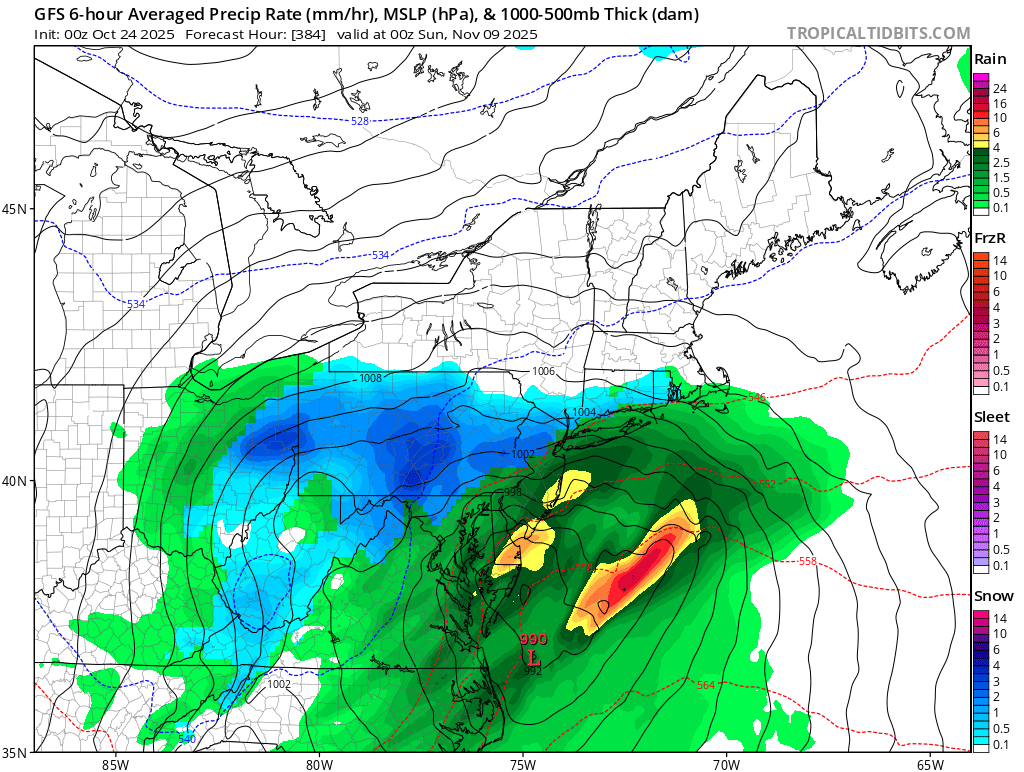
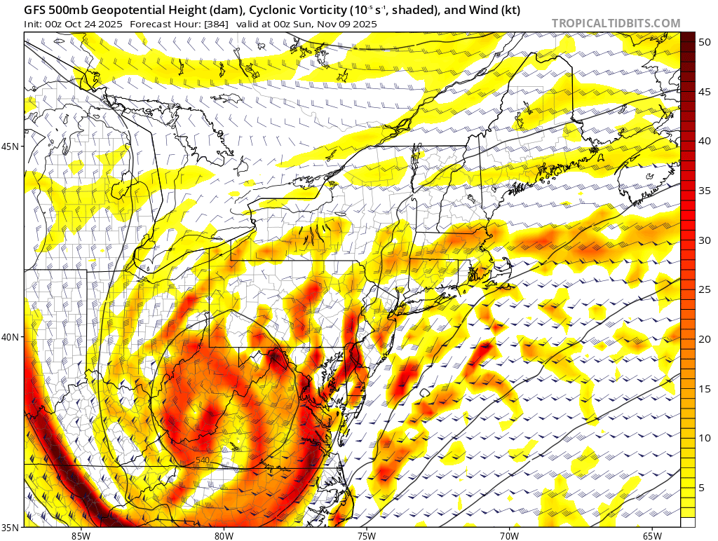
Big noreaster disappearing on the models. Flow is getting faster on the models.
-

Spooky Season (October Disco Thread)
MJO812 replied to Prismshine Productions's topic in New England
Big noreaster disappearing on the models. Flow is getting faster on the models. -
Traditionally, I live in one of the coldest areas in McDowell during ideal radiational cooling night. I'm close to the Catawba river and sheltered by mountains to my south.
-
If the clouds stay away, I bet tonight is colder for most of us.
-
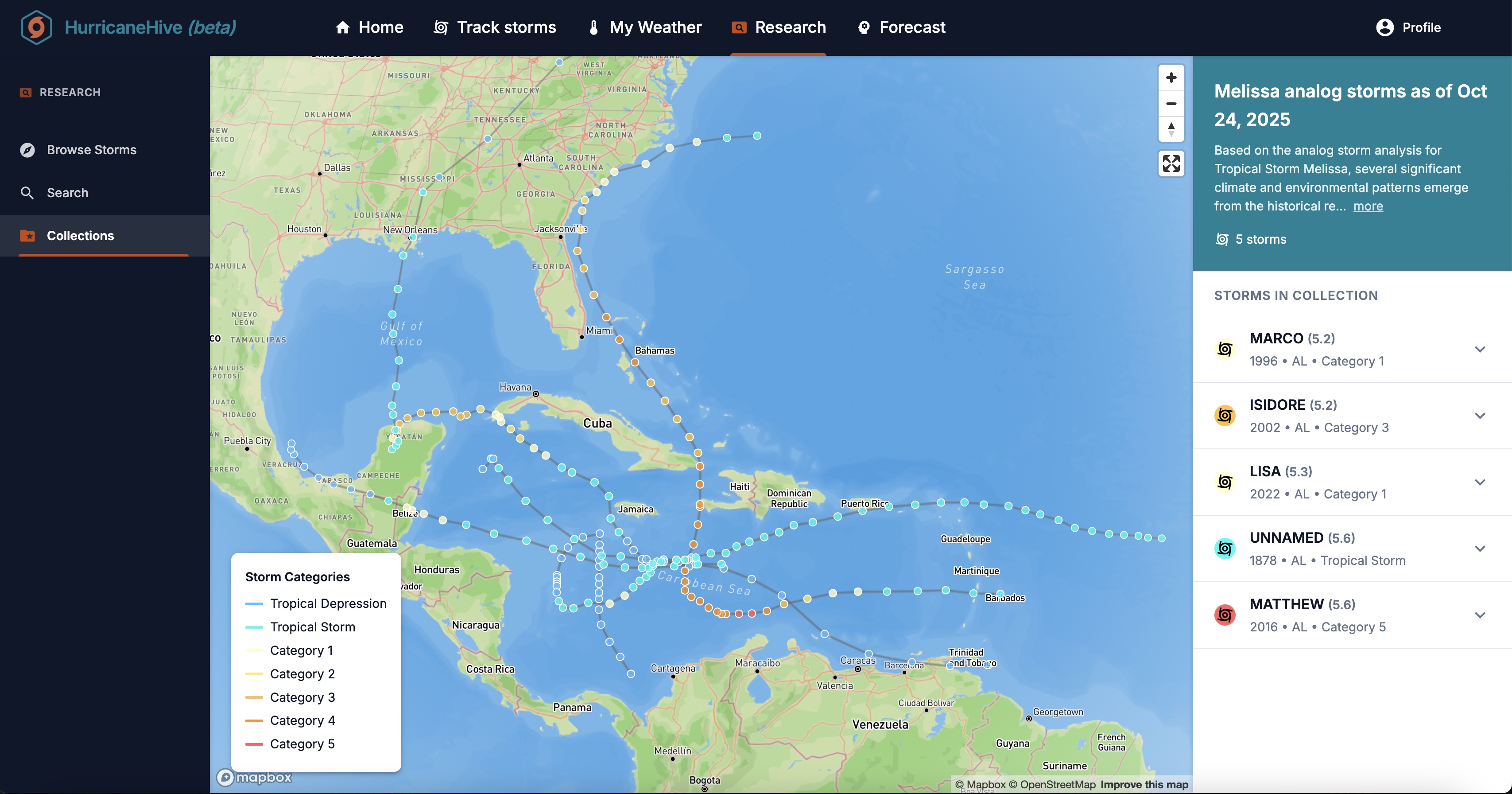
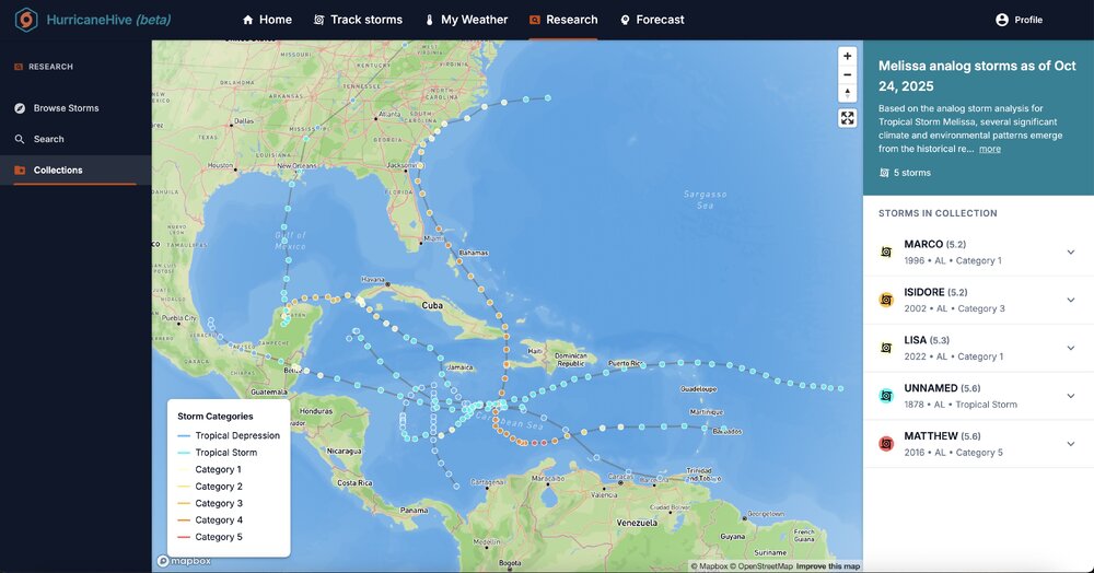
FWI, generated top 5 analogs for Melissa:
-
Kinda OT but willing to bet we see more startups with this goal in mind (reducing climate change itself) I’m interested to see governments worldwide react (or not) to this eventuality. Will every country have their own national player? Interesting to ponder. https://heatmap.news/climate-tech/stardust-geoengineering
-
With the slow motion and insane rainfall amounts we could be looking at a humanitarian disaster for Jamaica.
-
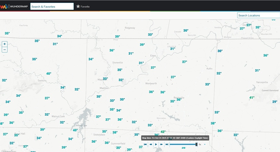
It was pretty cold in the North Central Piedmont of NC along the VA border this morning. The temperature at my location just west of Eden was 31.6°. There were also several other stations measuring temperatures below freezing, with one in Caswell County down to 29°.
-

Spooky Season (October Disco Thread)
powderfreak replied to Prismshine Productions's topic in New England
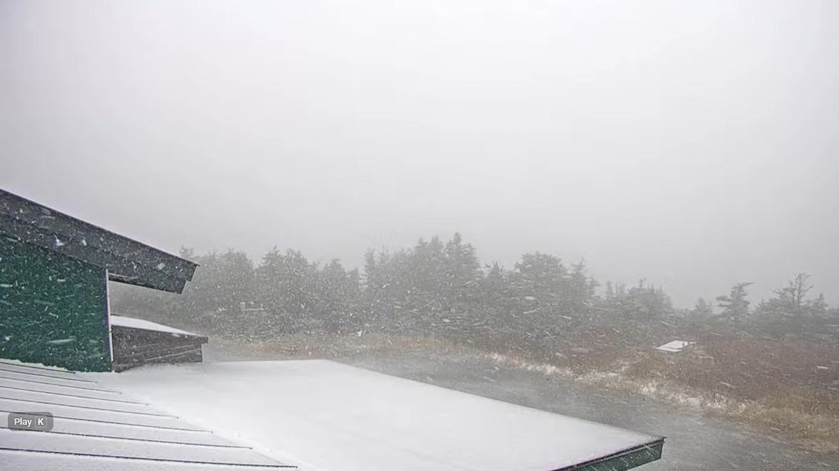
Snowing good up top.
-
The issue I have is once you start layering too many factors and being super specific for each (weak cold enso, PDO, AMO, QBO) you end up with such a small subset that it’s hard to say for sure the results are significant. Or maybe the better way to say it is it’s difficult to know what the chances of a “fluke” outcome are because that’s really what we’re hunting for. The truth is outside of Nino, all other winters the odds greatly favor a lower snowfall season. The vast majority of our good to great snow seasons fall under that category (1978, 1983, 1987, 1988, 2003,2005, 2010, 2015, 2016) with some chance we get a fluke cold/snowy year like 1979, 1982, 1996, 2014 in all “other” winters. And a slightly greater but still low chance we get a “decent” snowy or cold year like 1990, 1994, 2000, 2004 or 2006. But those are all kind of flukes. 70% of all non Nino winters end up pretty bad. And if you parse the analogs with so many variables to the point you only have 3-4 seasons in the list, you often end up not being able to tell what the odds of that fluke type season happening are because a sample that small might miss that fluke event unless you go back 100 years but then you’re using data on some of those variables that are less reliable. Just throwing my stream of consciousness out there. I do this too. Not sure how to account for it.
-
I don't have a weather station, just an indoor/outdoor set up. So I usually eyeball some local weather stations on Weather Underground when I am really curious on temps. This morning north of 40 in Iredell ranged from 33 to 38. I showed 38 too at home. The 33 station is very close by - looks like it is down in a valley where the S Yadkin cuts through. The point being location is huge difference maker on nights like last night as others were saying. The variance is pretty wild to us weather nerds I guess. Lots of scattered frost this week, but looks like November again this year before we get a killing frost/freeze.
-

2025-2026 ENSO
40/70 Benchmark replied to 40/70 Benchmark's topic in Weather Forecasting and Discussion
The season will average positive....that is a given, but I do think that we will see negative month. -
My farm in Franklin county dipped to 33.1 and the airport close to there was 35. Frost advisory verified outside urban areas it would seem. Still my point click had me down to 37 this morning so we missed significantly
-
Beautiful day. Going to take the boat out for one final spin and then winterize
- Today
-
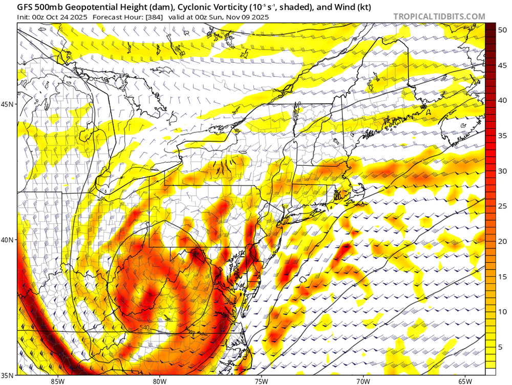
0z Gfs. Getting ready to switch over in the Metros. How many times on the Gfs would the 390hrs panel, if it existed, be money?

-
BULLETIN Tropical Storm Melissa Advisory Number 13 NWS National Hurricane Center Miami FL AL132025 1100 AM EDT Fri Oct 24 2025 ...AIRCRAFT DATA SUGGEST THAT MELISSA COULD BE REFORMING TO THE EAST... ...LIFE-THREATENING AND CATASTROPHIC FLASH FLOODING AND LANDSLIDES EXPECTED IN PORTIONS OF SOUTHERN HISPANIOLA AND JAMAICA THROUGH THE WEEKEND... SUMMARY OF 1100 AM EDT...1500 UTC...INFORMATION ----------------------------------------------- LOCATION...15.7N 74.6W ABOUT 215 MI...345 KM SE OF KINGSTON JAMAICA ABOUT 250 MI...405 KM SW OF PORT AU PRINCE HAITI MAXIMUM SUSTAINED WINDS...45 MPH...75 KM/H PRESENT MOVEMENT...ESE OR 105 DEGREES AT 2 MPH...4 KM/H MINIMUM CENTRAL PRESSURE...1001 MB...29.56 INCHES WATCHES AND WARNINGS -------------------- CHANGES WITH THIS ADVISORY: None. SUMMARY OF WATCHES AND WARNINGS IN EFFECT: A Hurricane Watch is in effect for... * Southwestern peninsula of Haiti from the border with the Dominican Republic to Port-Au-Prince * Jamaica A Tropical Storm Warning in effect for... * Southwestern peninsula of Haiti from the border with the Dominican Republic to Port-Au-Prince * Jamaica Tropical Storm Melissa Discussion Number 13 NWS National Hurricane Center Miami FL AL132025 1100 AM EDT Fri Oct 24 2025 The Air Force Reserve reconnaissance that has been flying through Melissa this morning found the center significantly further to the east-southeast than what was observed last night. How much of this position is related to a real motion, or a center reformation is unclear at this time. The storm remains about the same on satellite imagery this morning, with a large burst of deep convection, primarily along its southeastern flank, with evidence of northwesterly shear still undercutting the outflow. A WSFM microwave pass shows very deep hot towers, but not with that much structure beyond that. In addition, there hasn't been a significant change to Melissa's intensity, with peak 850 mb flight level winds of 49 kt, and these winds support maintaining 40 kt intensity this advisory. As has been stated for the last few days, the lack of persistent steering currents, due to competing mid-level ridges to the southeast and northwest of Melissa, is responsible for the storm's very slow motion. This is likely to continue for the next day or so, and much of the system's motion could be just as influenced by center reformations during this time period. After 24 hours, the mid-level ridge located to the northwest is expected to strengthen to the north of Melissa, and the guidance is coming into better agreement on a very slow westward motion through 72 hours. Beyond that time frame, a strengthening mid-latitude trough expected to move into the Southeastern U.S., should provide an avenue for Melissa to escape the Caribbean Sea to the northeast by the end of the forecast period. The track guidance overall has shifted south over the first few days, but there is still substantial spread in solutions at the end of the forecast period, related to when and how fast Melissa turns to the northeast. The latest NHC track forecast is a little south of the prior one early on, but is shifted a little eastward in 4-5 days, roughly a blend of the latest HCCA and GDMI model aid solutions. On the forecast track, Melissa could potentially be near western Jamaica by day 4 and near or over southeastern Cuba by day 5, though timing still remains more uncertain than usual. The GFS and ECMWF-based SHIPS shear guidance indicates the deep-layer shear is lower than yesterday, between 14-17 kt, but there still appears to be mid-level shear undercutting the outflow layer. Until Melissa also become better aligned vertically, any intensification is likely to be slow to occur over the next 12 h or so. After that, once Melissa's structure improves, environmental conditions still appear favorable for a period of rapid intensification (RI). Every single Google DeepMind member shows the system become a Category 4 hurricane or higher, and the uncertainty is more related on the timing of when RI occurs. After 96 hours, Melissa could weaken some due to the combined effects of land interaction, and an increase in southwesterly vertical wind shear by the end of the forecast period. The latest NHC intensity forecast is on the higher end of the model solutions, but more or less in line with the latest GDMI guidance. Key Messages: 1. Jamaica: Due to Melissa’s slow motion, the risk of a prolonged multi-day period of potentially damaging winds, heavy rainfall resulting in life-threatening flash flooding and numerous landslides, and storm surge continues to increase for Jamaica. Preparations to protect life and property should be rushed to completion, since strong winds and flooding rains could begin in Jamaica on Saturday or Sunday. 2. Haiti: Heavy rainfall will result in catastrophic flash flooding and landslides across southwestern Haiti into early next week. Extensive damage to roads and buildings is expected, potentially isolating communities for an extended period of time. This is a life-threatening situation and immediate preparations to protect life and property should be taken. Strong winds could also potentially last for a day or more over the Tiburon peninsula of Haiti. 3. Remainder of Hispaniola and Eastern Cuba: Heavy rainfall could also produce significant, life-threatening flash flooding and numerous landslides in southern Dominican Republic. Interests in Cuba should monitor the progress of Melissa since the risk of heavy rainfall, damaging winds, and storm surge appears to be increasing. FORECAST POSITIONS AND MAX WINDS INIT 24/1500Z 15.7N 74.6W 40 KT 45 MPH 12H 25/0000Z 15.9N 74.5W 45 KT 50 MPH 24H 25/1200Z 16.3N 74.6W 60 KT 70 MPH 36H 26/0000Z 16.5N 75.3W 70 KT 80 MPH 48H 26/1200Z 16.6N 76.0W 85 KT 100 MPH 60H 27/0000Z 16.6N 76.8W 105 KT 120 MPH 72H 27/1200Z 16.6N 77.5W 125 KT 145 MPH 96H 28/1200Z 17.5N 78.3W 130 KT 150 MPH 120H 29/1200Z 20.4N 76.7W 105 KT 120 MPH...INLAND $$ Forecaster Papin
-
Actually, it looks like a lot of places got frost and went down into the mid 30s, just not the big three airport locations, Hickory, Monroe, Rockingham, and Winston. The urban heat island did its thing.
-
Yeah but there's a troff thats been keeping them separate. When it lifts out, it should result in both a west turn and a center alignment.
-
Hey Anthony, I had just added this at the end right before you posted: The caveat is that this recent decades pattern of -NAOs during only weak sunspot periods has been due to randomness. I’m only looking at the period since 1980, when -NAO winters started becoming rare. There have only been 6 (13%) of them with a -NAO. All were within 2 years of a sunspot minimum with sunspots averaging <35 during DJF. I can’t prove it hasn’t been coincidental though. That’s why I said, Therefore, based on the last 45 winters and assuming that pattern continues, ~2028-9 should be the next winter with a good shot at a sub -0.25 NAO averaged out.
-

Spooky Season (October Disco Thread)
dryslot replied to Prismshine Productions's topic in New England
Was a thick frost here this morning on all surfaces, Low was 31.1°F, So far we've had a lot of low to mid 30's with one in the high 20's, Looking ahead though, It looks like 30's for the foreseeable future at night. -
Not so fast: https://www.columbia.edu/~lmp/paps/chiodo%2Betal-NATUREGEO-2019.pdf?utm_source
-
Calm conditions all night and clear skies so I do believe it was the lake. Gonna throw some ice in the water this afternoon and see if we can speed things up. Honestly, I love these microclimates. My old house was at the lowest elevation in probably a square mile and just off a creek. I’d consistently be 7° below the airport reading. New place is the exact opposite. It was almost Dec before the lake lost influence last year.
-
The Faalele debacle stinks to high heaven of favoritism. He's probably a "good kid" that Harbaugh dotes on. There is literally zero football reason he should be out there and it's become annoying as heck, smh It's gaslighting at this point.
-
Spooky Season (October Disco Thread)
dryslot replied to Prismshine Productions's topic in New England
Just don't bury it off trail or that's where it will remain unless you can get a skidder to get it out........... -
This may be one of those storms (hopefully) that takes far longer to get it together than the models predict. The current LLC is significantly displaced rom the MLC still, nothing big is going to happen until they stack.