All Activity
- Past hour
-
 Low across the south and off the SE coast would be what we want , but the way storms are playing out this winter , anything is possible. Probably really won't have any handle on a real track till about Wednesday... At the earliest IMO
 -

Friday February 6 FROPA / WINDEX small event
Modfan2 replied to HoarfrostHubb's topic in New England
Looks like decent banding now over higher terrain of Windham County -

Friday February 6 FROPA / WINDEX small event
TauntonBlizzard2013 replied to HoarfrostHubb's topic in New England
Not doing much here. About a half inch maybe a bit more. The euro nailed this screw some in between the two good bands -

Friday February 6 FROPA / WINDEX small event
MuddyWx replied to HoarfrostHubb's topic in New England
.gif.7c97de391902ca60f2c77a5d06dc9bf5.gif)
-

Friday February 6 FROPA / WINDEX small event
CoastalWx replied to HoarfrostHubb's topic in New England
Event blows so far outside of srn RI/Ginxy and Essex county. Was hoping for 3-6. Hopefully 3”. -

Friday February 6 FROPA / WINDEX small event
moneypitmike replied to HoarfrostHubb's topic in New England
North east of the RI band here in PVD. Snowing steadily and perhaps a couple inches. Flakes not terribly efficient. Looks like going 95 to 495 will be the smart choice for the trek to Mattapoisett. Looks like here to there will be a bit of a meh event. Congrats to those scoring big. -

Central PA Winter 25/26 Discussion and Obs
Blizzard of 93 replied to MAG5035's topic in Upstate New York/Pennsylvania
Interesting, yet MDT didn’t get it right. -

Friday February 6 FROPA / WINDEX small event
Go Kart Mozart replied to HoarfrostHubb's topic in New England
That tiny skinny band over SWCT is giving me a pretty good burst. -

Friday February 6 FROPA / WINDEX small event
Baroclinic Zone replied to HoarfrostHubb's topic in New England
About 1.5” here -

Friday February 6 FROPA / WINDEX small event
Ginx snewx replied to HoarfrostHubb's topic in New England
Congrats to her -
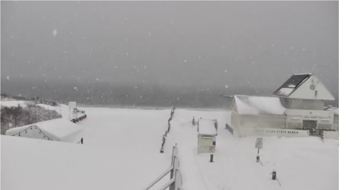
Ripping in Narragansett. https://www.georgesofgalilee.com/sky-cam/

-
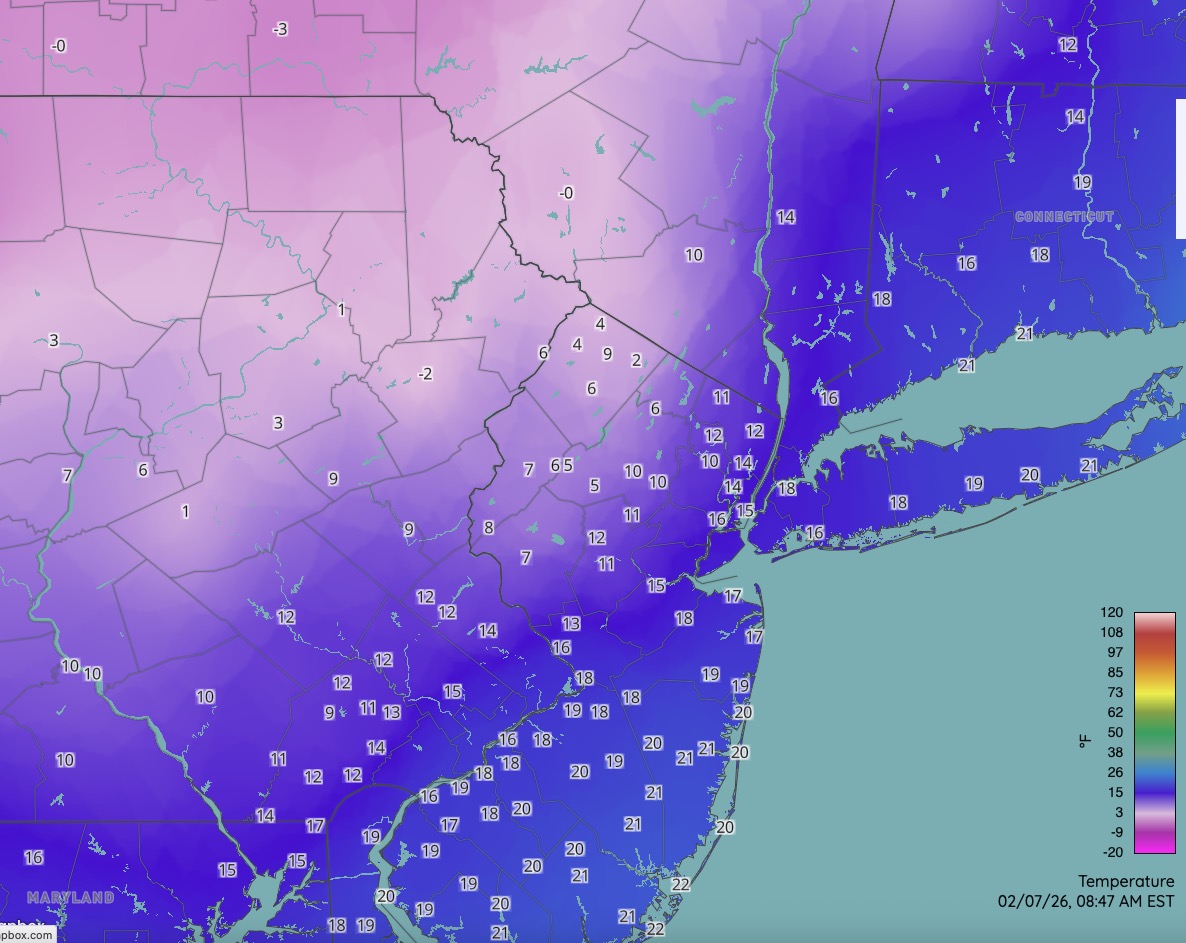
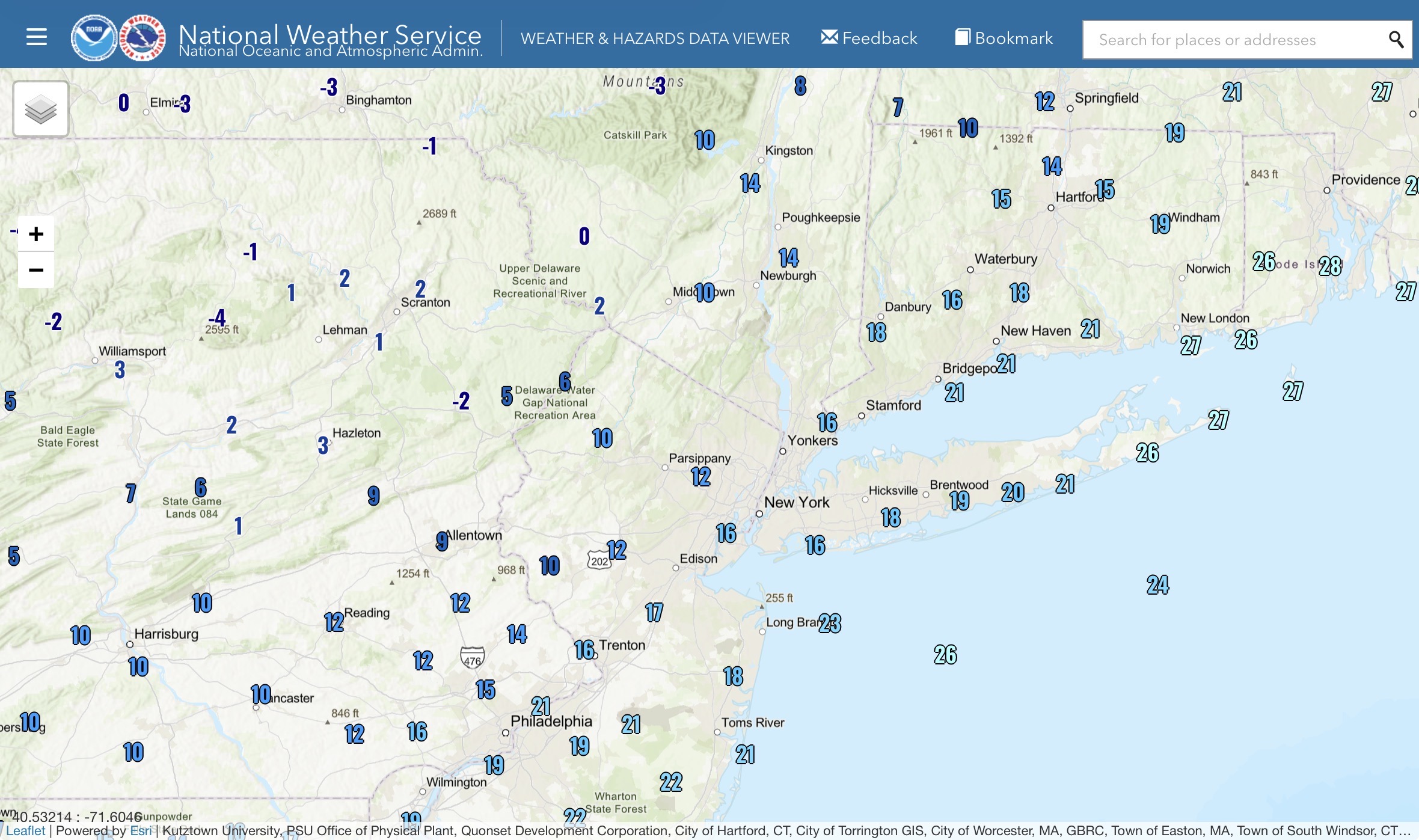
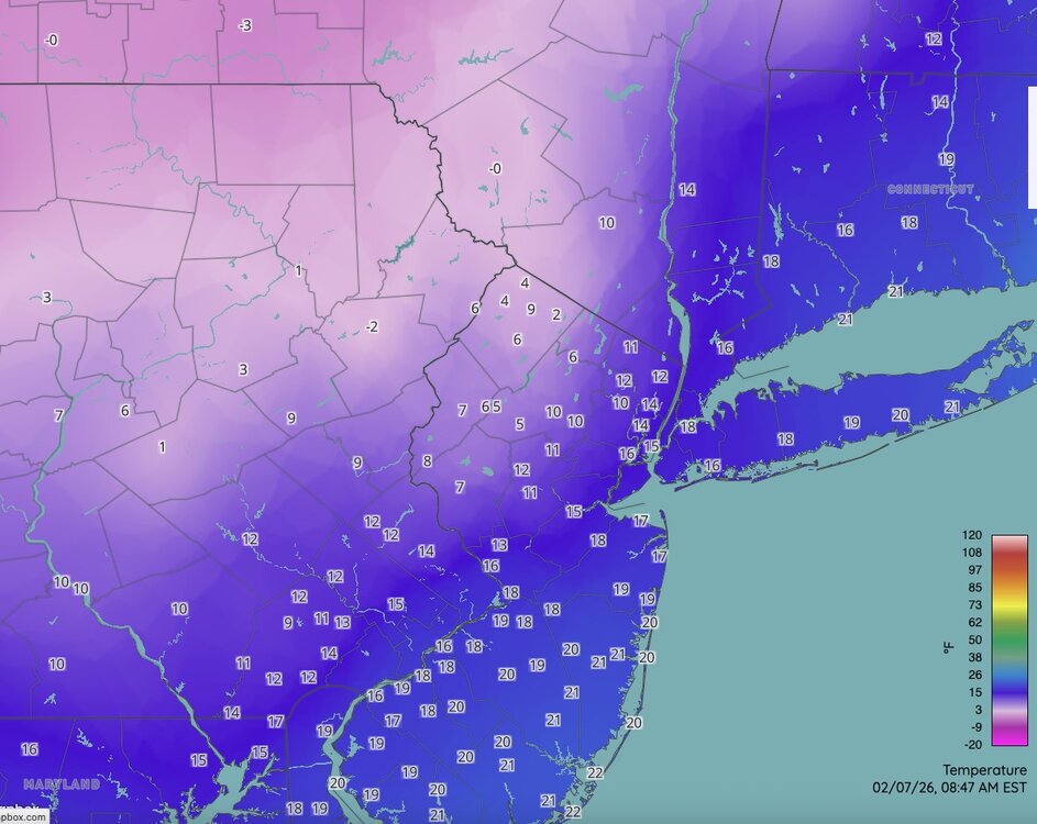
Chilly is an understatement brother!! -2 wind chill here!!
-
No precip here in Sparrows point MD but my anemometer recorded a 41 mph wind gust!!!! And I'm at 19.5 F !! Wind chills here -2!!
-

Central PA Winter 25/26 Discussion and Obs
CarlislePaWx replied to MAG5035's topic in Upstate New York/Pennsylvania
Down to +9.7 for current and low temp for today (so far). Had 0.4" of snow yesterday which melted down to 0.02". -
Woke up at 4am and didn’t notice anything, so went back to bed lol. Wind has marched in, though, and it is chilly out.
-
Had some light snow for a couple of hours last evening in the hours before mid-night. Woke up at 4:00 this morning to near blizzard conditions in a heavy snow squall as the Arctic front was moving through. Temperature was 21 degrees. Not sure exactly how long that squall lasted. Woke up again at 7:00 and winds were howling and the temperature had fallen to 7 degrees. Currently 5 degrees. Melted total in the the cylinder was .03", that was the easy part of the observation. Snowfall was very difficult to measure with the howling winds and the light fluffy snow. New snow was blown clear in some spots. Found a more sheltered location on the south side of the house and .70" was best measurement. Snow still blowing off rooftops and it looks and feels like the Arctic tundra out there. Fitting way to bring this prolonged bitter cold period to an end. Moderation is coming for next week....still cold though, no torch.
-

Friday February 6 FROPA / WINDEX small event
dmillz25 replied to HoarfrostHubb's topic in New England
Danvers up to 9” wow -

Friday February 6 FROPA / WINDEX small event
ma blizzard replied to HoarfrostHubb's topic in New England
arctic front interacting with the IVT now .. radar starting to look a lot more impressive -

February 2026 OBS & Discussion
coastalplainsnowman replied to Stormlover74's topic in New York City Metro
Montauk Circle traffic cam looking sweet right now. Following is the link with a blank before the "//" so that big image doesn't clutter the feed, also since it's been shared before: https: //www.youtube.com/watch?v=LL6HrtRsR3o -

E PA/NJ/DE Winter 2025-26 Obs/Discussion
Birds~69 replied to LVblizzard's topic in Philadelphia Region
Just looking at the radar over the past several hours I would think someone in New Jersey hit 2” inches…. -
Records: Highs: EWR: 60 (2020) NYC: 56 (2020) LGA: 58 (2020) JFK: 54 (2020) Lows: EWR: 5 (1993) NYC: 1 (1910) LGA: 5 (1993) JFK: 7 (1993) Historical: 1780: Unprecedented cold wave occurred in the winter of 1779-1780. All waterways in the Mid-Atlantic area including the Potomac River and most of the Chesapeake Bay. The cold weather set in during December of 1779 and area rivers were frozen by Christmas. The cold weather continued through the month of January and lasted until the first week in February. To the south Norfolk, Hampton, Newport News and Portsmouth were connected by thick ice that supported foot traffic between the ports. The James River could be crossed on ice near Williamsburg. Even further south, the Albemarle Sound was frozen thick enough to allow American soldiers to cross on foot. Thomas Jefferson noted that never before had the Tidewater frozen to such a large extent. On the beaches of the Delmarva, ice mounds piled up to a height of 20 feet as a result of breaking waves and frozen spray freezing on the beach. The ice mounds did not melt until spring. (p.30 Washington Weather Book 2002 by Ambrose, Henry, Weiss) 1835: On this date through the morning of the 10th, the earliest well-documented severe freeze occurred across northern Florida. Tallahassee dropped to 4° and Jacksonville & Pensacola fell to 8°. The edges of the St. Johns River froze and ice was reported in Pensacola Bay. The temperature was below freezing for over two days at St. Augustine. All citrus was killed. (Ref. Wilson Wx. History) 1861 — The temperature at Gouverneur, NY, bottomed out at -40 degrees, a drop of 70 degrees in one day. Two days later the mercury hit 55 degrees. (David Ludlum) 1861 — Hanover, NH, plunged from 37 degrees at 1 PM on the 7th to 32 degrees below zero at 7 AM on the 8th, and West Cummington MA plummeted 80 degrees to -32 degrees. Boston MA plunged from 46 degrees to -14 degrees, and on the 11th was back up to 60 degrees. (7th-8th) (The Weather Channel) 1899: A third area of low pressure moved in to DC on the 7th and dumped an additional 5 inches of snow bringing the snow cover in DC to around one foot.(p. 51 Washington Weather Book 2002 by Ambrose, Henry, Weiss) The arctic outbreak spread south of Canada on February 7, 1899, dropping temperatures to -61°F in Montana, -59°F in Minnesota, (a state record that stood for almost a century, until the village of Tower recorded -60°F on February 2, 1996). (Extreme Weather p. 63, by Christopher C. Burt) 1904: A tornado touched down in the southern tip of Illinois, hitting the towns of Meridian and Villa Ridge, north of Cairo. Parts of some barns were carried over a mile. Another tornado causing F2 damage in Clinton County picked up a two-story home, turned it around, and returned it to the ground. Oak trees with trunks 20 inches in diameter were "twisted into splinters". (Ref. Wilson Wx. History) 1920: A 4-day ice, sleet and snowstorm over New England and southeastern New York came to an end after dumping as much as 15 to 20 inches of frozen precipitation.(Ref. Wilson Wx. History) 1933: A 112 foot rogue wave was survived by the USS Ramapo in the Pacific Ocean. It is thought to be the highest wave ever observed and survived. It was caused by 70 mph winds over a large fetch. (Ref. Wilson Wx. History) 1934 — A deep freeze made it possible to drive from Bay Shore to Fire Island NY. (Sandra and TI Richard Sanders - 1987) 1936: On Friday February 7th, 1936 Richmond had 12.6 inches of snow and on the morning of the 8th Richmond had a low temperature of -10°F . 14.4 inches of snow in Wash. DC from 2355 on the 6th to 1645 on the 7th occurred the greatest snowstorm since Jan. 1922. A low pressure system formed to the east of Florida on the morning of the 6th and moved to a position about 60 miles east of Cape Hatteras. The first flakes of snow fell in Washington, DC just after midnight of the 7th and by late morning over a foot of snow had fallen. The total accumulation in Washington was 14.4 inches with a liquid content of 1.01 inches. Vertical weather accompanied the storm as temperatures fell to 16 degrees Fahrenheit during the height of the snowfall. Only 3 to 6 inches of snow fell in far northern and western suburbs. Norfolk recorded 9 inches of snow, the city's heavy snowfall in the last 40 years. (p. 60 Washington Weather Book 2002 by Ambrose, Henry, Weiss) Over 14 inches of snow fell in the Northern Virginia with greater amounts in the Skyline Drive area. The heavy snow set the stage for the great spring flood in March when warm temperatures brought a sudden thaw to the snow pack. Following the snow, Richmond's temperature fell to a record low for the month reaching -10 °F. (Ref. Virginia Weather History) 1967: A strong low pressure system created near blizzard conditions in the middle Atlantic religion. The brief, but intense storm produced 10 to 12 inches of snow across Washington, DC area. Light snow broke out during the evening of February the 6th. The snow remained light to moderate through the night, and then became heavy around daybreak. Snow accumulated at 1 to 2 inches an hour between 6:00 a.m. 11:00 a.m. and quickly ended around noon on the 7th. The storm dumped 10.3 inches of snow an it National Airport and 11.7 inches at Dulles generally, 10 - 12 inches of snow fell throughout the area.(p. 79-80 Washington Weather Book 2002 by Ambrose, Henry, Weiss) (Ref. Wilson Wx. History) Ref. (NWS Ranking for Storms between 1956 and 2011) This is the 33rd Worst Snowstorm 1971: A waterspout came ashore at 4:18 AM and caused F2 damage to an expensive apartment complex in Gulf Breeze, Florida. 112 people were hurt. The tornado formed near Santa Rosa Island and moved ashore at Navy Cove, Florida. (Ref. Weather Guide Calendar with Phenomenal Weather Events 2012 Accord Pub. 2011, USA) 1978 — The worst winter storm of record struck coastal New England. The storm produced 27.5 inches of snow at Boston, and nearly 50 inches in northeastern Rhode Island. The fourteen foot tide at Portland ME was probably the highest of the century. Winds gusted to 79 mph at Boston, and reached 92 mph at Chatham MA. A hurricane size surf caused 75 deaths and 500 million dollars damage. (David Ludlum) 1987 — Low pressure in Manitoba, Canada, pulled warm air up from the Gulf of Mexico, and more than forty cities in the north central U.S. reported record high temperatures for the date, including North Platte NE and Rapid City SD with readings of 73 degrees. (The National Weather Summary) 1988 — Twenty-two cities in the eastern U.S. reported record low temperatures for the date, including Binghamton NY with a reading of 5 degrees below zero. Snow blanketed southern Louisiana, with three inches reported at Cameron. (The National Weather Summary) (Storm Data) 1989 — Twenty-five cities in the western U.S. reported record low temperatures for the date. Lows of 16 at Las Vegas NV, 26 at Bakersfield CA, -29 degrees at Milford UT, and -16 degrees at Reno NV were February records. The low of 43 degrees below zero at Boca CA was a state record for the month of February. In Utah, lows of -32 degrees at Bryce Canyon, -27 degrees at Delta, -29 degrees at Dugway, and -38 degrees at Vernal were all-time records for those locations. (The National Weather Summary) 1990 — A slow moving cold front spread heavy snow across the state of Utah. Storm totals ranged up to 31 inches at Alta, with 24 inches at reported Brighton and 23 inches at Snowbird. Bitter cold weather prevailed across Alaska for the thirteenth day in a row, with morning lows of -42 degrees at Fairbanks, -48 degrees at Nenana, and -54 degrees at Bettles. Anchorage AK reported a record low of 23 degrees below zero. (The National Weather Summary) (Storm Data) 1991: Dense fog resulted in a 74 vehicle pile-up on Highway 99 in Fresno County, California resulting in three deaths and 31 injuries. In another area of Fresno County, a truck drove onto railroad tracks and was struck by a train, resulting in one death. (Ref. Wilson Wx. History) 1994: Snow falling over the area produced heavy accumulations from central into northeast South Dakota with 11 inches at Kennebec and 8 inches at Watertown through the 9th. Extreme cold accompanied and followed the snow with low temperatures of -52 °F at Promise and -45 °F at Aberdeen on the 9th. Snow accumulation caused a roof to cave in on a drugstore at Bristol. A man died of exposure attempting to walk home near Sioux Falls after his car became stuck in a ditch. (Ref. Wilson Wx. History) 2002: Oregon experienced their worst windstorm since the Great Columbus Day Blow of 1962 as developing low pressure moved into the southwestern part of the state. Winds gusted to 88 mph at Bandon, OR. (Ref. Wilson Wx. History) 2003: Snow started at 1847 on the 6th and end on this date at 0655 with a total snowfall of 6.9 inches the most since 1-25-2000 (10.8 inches) an the most in Feb. since 2-16-1996 when 10.8 inches also occurred. (Ref. Annandale Virginia Weather Records ) 2008: Alaska: An arctic high centered along the Alcan border separating eastern Alaska and Canada's Yukon Territory cause morning temperatures across eastern interior Alaska to lower than minus 60 °F at nearly a half dozen locations. The temperature dropped to minus 72 °F at Chicken, marking the lowest official temperature in the state in more than eight years.(Ref. WxDoctor) 2017 — Six tornadoes traveled across southern Louisiana. The strongest tornado, an EF-3, impacted eastern New Orleans.
-
Agree. Fact is, potential is there not just for next weekend but some period beyond that as well. It doesn't appear to be wall to wall shit the blinds. (Oh no, I posted medium range discussion in the Banter thread rather than banter in the Medium Range thread!!! LOL!! )
-

-
It’s crazy how DC will have an above freezing high temp for today
-
Ongoing ground blizzard with the wind, 13F.