All Activity
- Past hour
-
How come didn’t thank me who provided the same explanation with much less verbiage?
-
Stein hands all over my face missing rain east and west.
-
Thank you for the explanation.. it must of been wild sucks I missed it.. if only knew.. this would of been before the main line even came. It was the stuff out of front of it.. probably around 330ish
-
-
tornado watch and also enhanced risk for tornadoes in Texas
-
Looks like Western Suffolk to Middle Island about to get some serious rain in the next hour. West and east of that…not so much. Amazing how much the sky has changed in my train ride west.
-
Looks good daytime Saturday and mild most of next week on the 12z runs
-
The trailing edge of the precip is about to come through my area. HRRR says it rains the rest of the day, but radar isn't backfilling further east so maybe we get a lull for a while
-
lol
-
I have racked up 0.80" so far since the rain began on Monday, so not a major bust up here. Holding fairly warm at 40 degrees, so snow chances at my elevation are looking pretty low.
-
Sure. A gust front
-
I would mind living near MAF for like April/May/early June
-
Been a train of heavy rain since 1030 here.
-
Who's got SE winds at 500mb? Me. You.
-
7.36” max to our north is improving the drought conditions there.
-
this was by Midland Odessa last night
-

E PA/NJ/DE Spring 2025 Obs/Discussion
The Iceman replied to PhiEaglesfan712's topic in Philadelphia Region
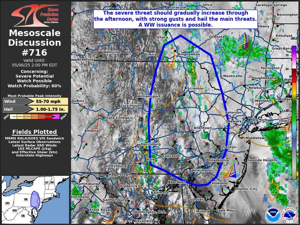
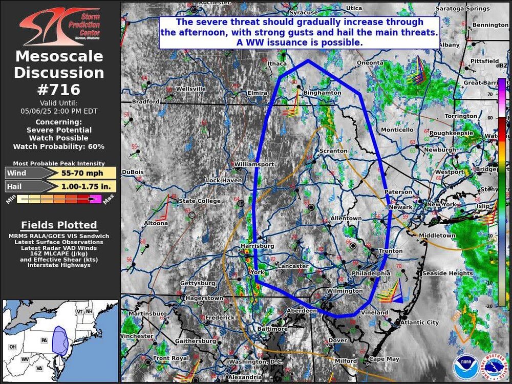
Mesoscale Discussion 0716 NWS Storm Prediction Center Norman OK May 6, 2025 16:01Z Areas affected...portions of eastern Pennsylvania into western New Jersey and far southeast New York Concerning...Severe potential...Watch possible Valid 061601Z - 061800Z Probability of Watch Issuance...60 percent SUMMARY...The severe threat should gradually increase over the next several hours. The stronger storms will be capable of strong wind gusts and perhaps large hail. A Severe Thunderstorm Watch issuance may be needed if appreciable strong storm coverage becomes apparent. DISCUSSION...Insolation is modifying the boundary layer amid some persistent cloud cover, remnant from earlier showers and thunderstorms, which is warming temperatures through the 60s F. Cooling temperatures atop a destabilizing airmass from the approach of a pronounced upper trough, and minimal convection inhibition, is supporting relative robust updraft development across southeast PA (per MRMS mosaic radar imagery). Through the day, further heating should boost MLCAPE to over 1000 J/kg, which should be adequate for scattered strong to potentially severe storms given expected 40-50 kts of effective bulk shear. Current regional VADs and short-term RAP forecast soundings depict a unidirectional vertical wind profile with elongated, straight hodographs. As such, linear multicellular clusters and transient supercells should be the primary modes of convection for the stronger storms that manage to develop. Strong, damaging gusts are possible later this afternoon once the boundary layer destabilizes. Given colder temperatures aloft overspreading the Mid-Atlantic into the Hudson Valley, large hail cannot be ruled out either. Therefore, if robust storm coverage becomes apparent, a Severe Thunderstorm Watch may be needed within the next few hours. ..Squitieri/Gleason.. 05/06/2025 suns out here in Levittown now -
tornado warning near Rosebud
-
Very heavy showers coming through now...whoa! Looks to be a small cell that just kinda popped.
-

Central PA Spring 2025
Mount Joy Snowman replied to canderson's topic in Upstate New York/Pennsylvania
Heck yeah but so far everything seems to be juuuuuust to my west. Some serious Training going on in eastern Dauphin Co. -
And here in Tamaqua we have broken clouds and sunshine. We'll see if that helps any storm formation later.
-
I had a quick 30 seconds of rain here in 21057 from it. Maybe something to my south pushing up in 15-30 minutes if it can hold together.
-
Its May, Its Green. I am all in on warmth.
-
As an example, as the storms approached BOX you could start to see a faint echo representing the gust front/outflow. Conditions were really conducive to forming strong cold pools. and so the leading edge of the wind was approaching Danvers when you wouldn't have seen rain until you got to Newburyport. That's one way to do it. Another is a dry microburst. That is more of a western CONUS thing. You need deep dry air in the lower levels, which evaporates all the precip before it hits the ground. However you still get evaporatively cooled air that accelerates to the ground and can be quite strong. MAF a week or two ago gusted to over 100 mph from a dry microburst.
-
Rain is approaching my area I can hear thunder now.