All Activity
- Past hour
-

December 2025 regional war/obs/disco thread
40/70 Benchmark replied to Torch Tiger's topic in New England
For ya mutha -
Still think we got another 36 hours or so til Sunday is figured out. There continues to be a risk of anything from C-1 inch, several inches, a rainer, or a miss completely. I am still not that sold on any major warmup, unfortunately there may be a 3-5 stretch that hits the XMas window dead on but until that WPO as Don has pointed out goes positive there is a chance that ridging isn't extended to the E Coast or the NE for more than just a brief period. The EPO pop too on the EPS drops back towards neutral by 12/25
-
.thumb.png.4150b06c63a21f61052e47a612bf1818.png)
December 2025 regional war/obs/disco thread
HIPPYVALLEY replied to Torch Tiger's topic in New England
Bennington is kind of a snow hole, they get shadowed in all directions. -
For DC or SNE?
-
they need to start making hallmark movies where it's 45 and raining on christmas
-
December 2025 regional war/obs/disco thread
40/70 Benchmark replied to Torch Tiger's topic in New England
https://easternmassweather.blogspot.com/2025/12/plowable-snowfall-still-favored-sunday.html First Call probably tomorrow or Friday, barring an unforeseen "poof". -

December 2025 regional war/obs/disco thread
HoarfrostHubb replied to Torch Tiger's topic in New England
Bennington, below 1000'... so she probably won't hit the warning amounts -
IIRC... after the deep freeze... it really never got cold again.
-
December 2025 regional war/obs/disco thread
HIPPYVALLEY replied to Torch Tiger's topic in New England
Some sunshine coming through the clouds now. Zero precipitation yet. -
Winter 2025-2026 Offers Return to Normalcy
40/70 Benchmark replied to 40/70 Benchmark's topic in New England
Plowable Snowfall Still Favored Sunday Devin In Details As Considerable Model Uncertainty Remains Rainfall Likely Tonight Regardless of the ample supply of cold throughout the first third of the month of December, the storm system approaching the region today still looks to fall as primarily light rainfall for the majority of the region. The rising temperatures throughout the overnight period last night were the first indication of this outcome, as an innocuous looking wave over the Ohio River Valley manages to phase in enough with a lobe of the PV to amplify and track through southern Canada, which has already turned the winds out of the southwest across much of the northeastern CONUS. Although some light snowfall is possible across the higher terrain of the Berkshires, this particular system will prove more met than white. This is a very easy forecast since the system is traveling so far to the north, however, when that is not the case, modeling will be very sensitive to any subtle change with respect to phasing attempts is an extremely fast flow. This will be on full display with regard t the weekend forecast. Complicated Weekend Scenario Unfolding As of this morning, there were two more distinct parcels of energy over the arctic that are modeled to be on a collision course over the Canadian prairies late this week. The system over the Arctic Ocean, and the one entering Alaska are forecast to rapidly funnel SSE in the flow between the PV and west coast ridge, before ultimately coalescing in the vicinity of Alberta, Canada on overnight on Friday. The system will then careen around the southern side of the PV on Saturday, at which point guidance diverges concerning the precise nature of this crucial interaction. The European cluster of ensembles favors a scenario in which there remains enough space between the PV lobe and the developing system to allow to amplify sufficiently as to eventually impact much of the region with a plowable snowfall on Sunday. The GFS camp, on the other hand, keeps the PV in close enough proximity to greatly impede the development of the wave to the south by largely shearing it apart, which results in little if any snowfall across the area. The version of the EURO guidance that is derived from Artificial intelligence (AI) is even more aggressive than the traditional model, and implies a warning event of 6" or greater throughout at least a portion of the area. The Eastern Mass Weather hedge remains in favor of a plowable snowfall for at least a portion of the forecast area on Sunday given previously discussed analog support and teleconnector convergence, in addition to robust AI support in addition to a death of high latitude blocking at present to pin the PV slightly further to the south. First Call is likely either Thursday or Friday. -
.jpeg.78e4365d6dba986d78e64a60801b5bcd.jpeg)
-
Expecting 1" or so then some glop. Won't matter in a couple weeks anyways if models are right.
-

Pittsburgh/Western PA WINTER ‘25/‘26
Rd9108 replied to Burghblizz's topic in Upstate New York/Pennsylvania
Long Range RGEM looks like a hit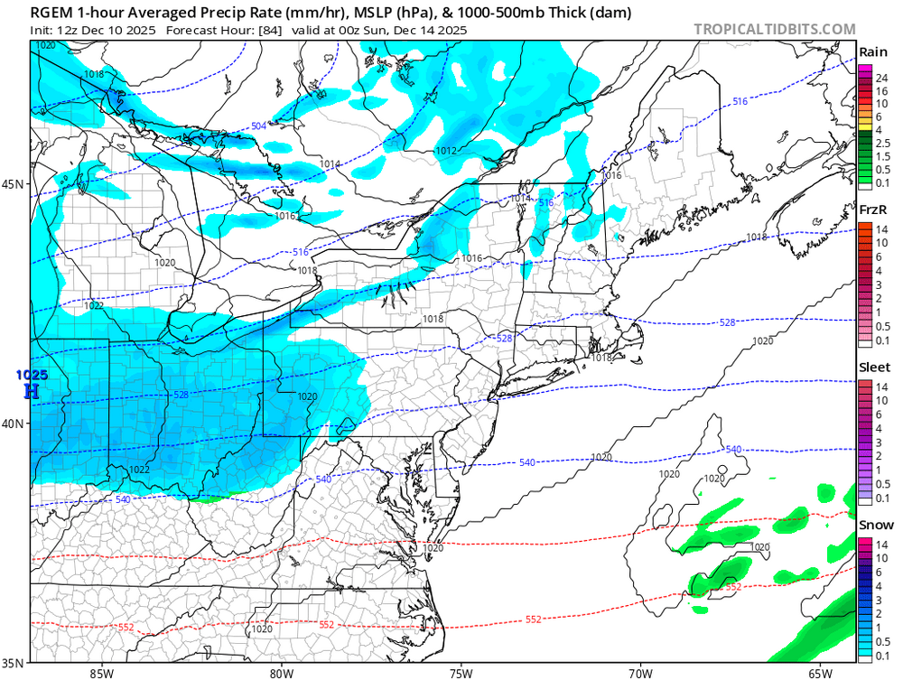
-

December 2025 regional war/obs/disco thread
backedgeapproaching replied to Torch Tiger's topic in New England
What town is she in? -
Yeah, I think that was the coldest Xmas of the 20 year period and it was the worst snowfall year ever for MBY.
-
Per yesterday’s Euro Weeklies, it’s overall looking to average mild from the Mid-Atlantic-OH Valley-lower Midwest south for most of the 4 week long period 12/22-1/18. Could it end up verifying well? Of course, especially the earliest portion, when statistically there’s more skill. Will it? Nobody could possibly know, of course! Notwithstanding the poor performance for the 3 weeks from just before Thanksgiving through mid Dec, the Euro Weeklies have been just good enough at foretelling general trends that they shouldn’t be ignored by any means. But could they largely end up failing, especially for the Jan portion? Of course they could.
-
5.5” and still snowing. Not bad since we were never even under an advisory until most of this fell. Still snowing and looks like we could still get another 2-3”. .
-
Funnily enough, the last time we had a really cold xmas was in dec 2022. Torchapalooza afterward. So if there is going to be a torch, I’ll take one before prime climo.
-
Since 1995-1996 we have had 15 La Niña winters as defined by the RONI index. 14 out of 15 of those winters followed a repeating pattern which has been common the last 30 years. EWR, NYC, and LGA December snowfall pattern repeated throughout the entire winter. The Decembers with under 4” of snowfall at those stations went on to below average seasonal snowfall. With the Decembers over 4” or snow featuring average to naive average snowfall. You might ask how can this work out over 90% of the time? My guess is that La Ninas tend to show what they are capable of early on in the season. Plus as our climate has warmed it has lead to more repeating and persistent patterns. So I view this December to winter snowfall relationship more as a marker of a deeper underlying shared pattern rather than something that is directly causing the outcome. What is misleading about showing the long term snowfall trend in NYC since the regular observations began in the late 1800s? As the long term climate has warmed, the snowfall has gone down. There have been shorter term up trends like from the 80s to 10s against the long term decline. Plus snowfall measurements prior to the 1980s would be higher if measurements were taken as frequently as we do today.They also substituted melted down snow gauge measurements at times like in 1888 blizzard which undercounted the higher ratios back in the much colder era. So the actual downward trend line is steeper if we correct for the different way we measure snow now.
-
Evergreen quote for this subforum.
-
Looks like the post-Xmas 1984 warm shot. ORH hit 70F in that. Latest 70F on record.
-
Its a wait and see type deal for the fence sitters.
-

12/12: The little Friday clipper that could? Or won't.
H2O replied to dailylurker's topic in Mid Atlantic
Is this thread for the Sunday event or Xmas warm up? -
I mentioned in the other thread I thought this might verify colder than modeled. Might not mean much in terms of sensible wx but could make a difference hyper locally
-
I got $20 that temps on Xmas will NOT be what a model two weeks before says it will be.