All Activity
- Past hour
-

The “I bring the mojo” Jan 30-Feb 1 potential winter storm
Ravens94 replied to lilj4425's topic in Southeastern States
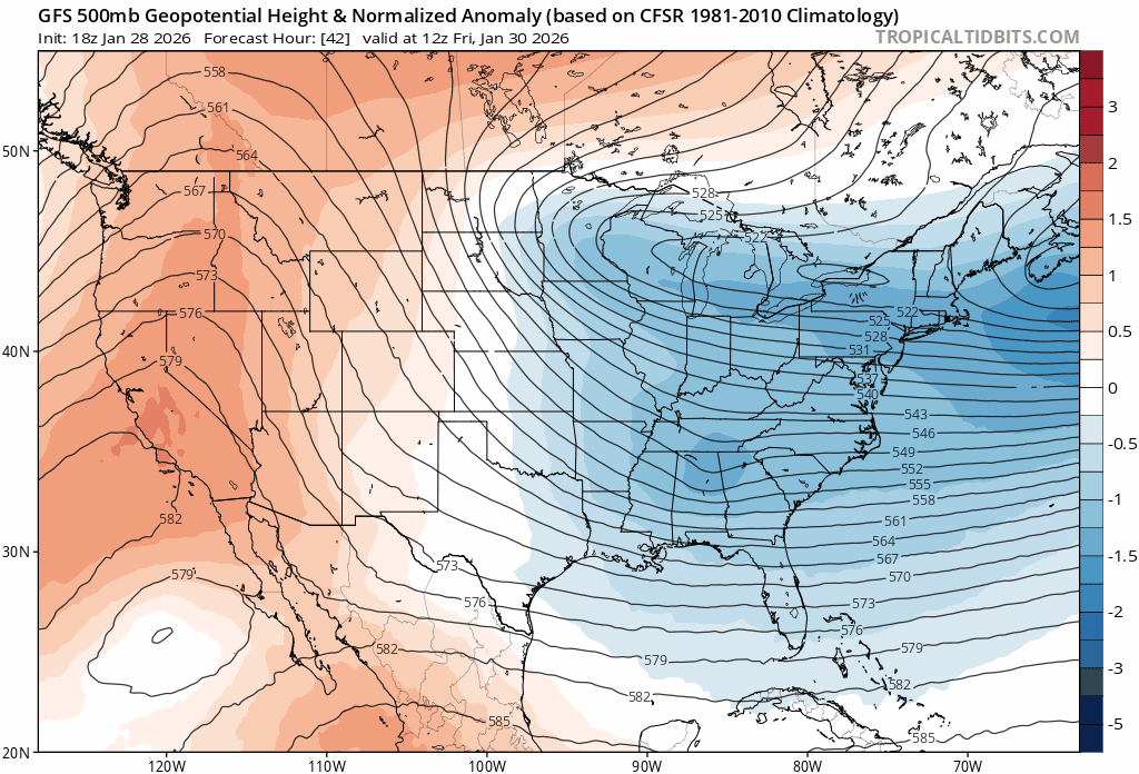
Gfs is changing in the NE every run. This run may cut off faster also.
-

Possible coastal storm centered on Feb 1 2026.
Damage In Tolland replied to Typhoon Tip's topic in New England
Solid trends so far kicking off 18 Zed -

The “I bring the mojo” Jan 30-Feb 1 potential winter storm
KChuck replied to lilj4425's topic in Southeastern States
Mine also -
NWS still seems pretty bullish here .
-

The “I bring the mojo” Jan 30-Feb 1 potential winter storm
wncsnow replied to lilj4425's topic in Southeastern States
118 members strong! Glad to see the site popping! -

The “I bring the mojo” Jan 30-Feb 1 potential winter storm
UnionCountyNCWX replied to lilj4425's topic in Southeastern States
Imma read the rest when I have time, but this is the first thundersnow ive heard mentioned. -
ready for spc outlooks to be the most confusing thing ever? https://www.spc.noaa.gov/exper/conditional-intensity-information/
-

Possible coastal storm centered on Feb 1 2026.
Torch Tiger replied to Typhoon Tip's topic in New England
even the ICON isn't budging from it's solution last night. very very consistent with a cape scraper enroute -
The “I bring the mojo” Jan 30-Feb 1 potential winter storm
UnionCountyNCWX replied to lilj4425's topic in Southeastern States
Someone mentioned it a minute ago, but the OBX are about to get smoked. Not sure if thermals are good for snow (I haven't looked) but man gonna be a good storm down there. -
Ended up falling to 21.2 this morning and topped out at 34.6 this afternoon
-
ENJOY! If I were single, I would be booking a rental in OBX and hang out at Lucky 12 or maybe Goombay's (more windows) until the kicked me out or lost power, whichever came first. Oh shoot, Black Pelican, wall of windows and a fireplace at the bar.
-

The “I bring the mojo” Jan 30-Feb 1 potential winter storm
Grayman replied to lilj4425's topic in Southeastern States
He is awful. Bring back the fish. They prefect their job is take model output and turn it into a forecast. Like you said he just reads the Euro output -

The “I bring the mojo” Jan 30-Feb 1 potential winter storm
Snowncanes replied to lilj4425's topic in Southeastern States
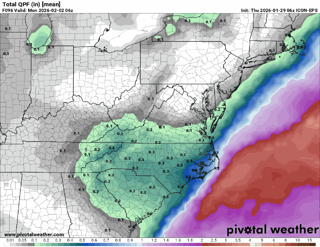
WPC put out a great discussion. A little long to quote so here’s the link. https://www.wpc.ncep.noaa.gov/discussions/hpcdiscussions.php?disc=qpfhsd -
They are rather bullish for SEVA
-
The crazy thing is this still isn't that far off yet seems so far given how steady the models have been.
-

Richmond Metro/Hampton Roads Area Discussion
chris624wx replied to RIC Airport's topic in Mid Atlantic
I've never seen thundersnow. I would die if that were to happen with this storm! -
Yup, same here which I'm looking for some higher amounts honestly. Saturday and Sunday the highs are going to be in the teens. Sunday mornings low looks to be negative 2 degrees and Monday morning looks to be about 3 degrees.
-

Possible coastal storm centered on Feb 1 2026.
SouthCoastMA replied to Typhoon Tip's topic in New England
Yes, overall it was an increase in precip for se areas. Will need all guidance to start moving towards Euro by 0z, if the 18z run doesn't fold. -
The “I bring the mojo” Jan 30-Feb 1 potential winter storm
Ravens94 replied to lilj4425's topic in Southeastern States
-
Whatever model wvlt used showed 4 inches for my area, 5 for Knoxville, and 6-8 east of there.
-

The “I bring the mojo” Jan 30-Feb 1 potential winter storm
btownheel replied to lilj4425's topic in Southeastern States
He seems to add extremely little value. We can all read the Euro outputs as well. . -
Its essentially just an ocean effect snow event now.
-
"These bands of heavy snow in eastern NC andsoutheast VA depict 700-500mb lapse rates >6.5C/km Saturdayafternoon and evening. It is here where not only are 2"/hr snowfallrates achievable, but so is the likelihood for thundersnow. Theintense vertical velocities in eastern NC and southeast VA may...."
-
Yes.