All Activity
- Past hour
-
28 degrees at 5:30 am, will probably drop another degree or 2 before sunrise. This blows. A forecast high of 48 with wind chills in the low 30's this afternoon. We usually have outdoor activities for st Pat's day downtown. I'll stay home. I already see black on the tips of just bloomed perennials. Wondering how much damage there will be to plants and such that bloomed already.
-
Strongest wind gust here was 55mph.
-
Pretty underwhelming. 1.26" rn, max gust 31. 54f Sent from my SM-S921U using Tapatalk
-

Central PA Spring 2026 Discussion/Obs Thread
Voyager replied to Voyager's topic in Upstate New York/Pennsylvania
Not sure if it's wind (downed trees) or snow related, but 309 over the Blue Mountain has been closed all night. Trying to get a hold of my night shift truck partner to find out why. -
 Don’t know exactly what wind gusts IMBY were but I wouldn’t doubt severe verifying level. Not sure I ever heard a thunder clap or saw lightning yesterday despite 2 STWs. Heard sleet on the window around 11-1130.
 -
 1025 PM Tstm Wnd Dmg 2 SE Ridgely 38.92N 75.86W 03/16/2026 Caroline MD Public Several full trees down and intense storm damage reported. Holly Road is closed from 404 to Central Avenue due to trees down. Possible tornado. Time estimated from radar. 1025 PM Tstm Wnd Dmg Ridgely 38.95N 75.88W 03/16/2026 Caroline MD 911 Call Center Several reports of trees down in Ridgely, including one onto a house with minor structural damage. Time estimated from radar. Also damage reported in Talbot, Kent, and Queen Annes County
 -
.74" event total...snow finally wiped except for the 3' drift near the fence...still a few inches there.
-
 This is very sad news. He was a fantastic member. May he rest in peace.
 - Today
-
Looking a little warmer for us in the medium/long range, under constant +nao
-
I am very sorry to learn this sad news. He was a great member and good person.
-
Fucking wind was wild. Not sure what got loose but something kept banging the side of my house. Maybe downspout but did notice a loose shingle.
-
Probably had some gust near 60.. hard to sleep.. turned out to be a good event
-
59kts logan
-
If NYC can catch the beginning of a transition from ENSO neutral to a developing Super El Nino when it's cold... boy that winter would rock and roll for us. Constant threats of KU storms. It would be a winter Weenie's dream come true.
-
had to be easily 60mph gusts here
-
 Wow I’m so sorry to hear about Roger. May he Rest in eternal Peace
 -
.thumb.jpg.6a4895b2a43f87359e4e7d04a6fa0d14.jpg)
Central PA Spring 2026 Discussion/Obs Thread
Yardstickgozinya replied to Voyager's topic in Upstate New York/Pennsylvania
Educational only, there's no forecast Cameron's channel. Howdy, I’m Cameron. I’m a research scientist, storm chaser, and photographer.I work closely with the National Weather Service and Storm Prediction Center to better understand and forecast supercells, their hazards(tornadoes, hail, and wind, and their many behaviors. I’m also a proud member of the storm chasing community, and an advocate for strengthening ties between chasers, researchers, and forecasters. I regularly provide educational material to NWS, SPC, and the chaser community, with the goal of communicating and implementing new research.Portrait courtesy Will Wight What I’m known for: Hodograph Training Presented at SPC, ESSL, NWS Southern & Central Regions, and various NWS WFOs (link)Implemented in NWS WOC Severe Training Course (link)Hodograph MapImplemented by the SPC, CoD, Pivotal Weather, and Tornado ArchiveAwarded American Meteorological Society “Special Award”Storm Interactions & “Nudgers”Presented at SPC, various NWS WFO -
 Magnolia Felton Delaware 13 & Irish hill rd no power trees down, power crews out. 1020 p.m. tornado warnings, where in the basement. Wife and daughter heard the wind and I told them that what a tornado sounds like. I don't know if one hit, but scared the shit out of me. There cutting trees on all the back roads. Power trucks all over. Will see what it looks at day break when I go home from work.
- 1,034 replies
-
- 2
-

-
- severe
- thunderstorms
- (and 1 more)
-

E PA/NJ/DE Spring 2026 Obs/Discussion
BBasile replied to PhiEaglesfan712's topic in Philadelphia Region
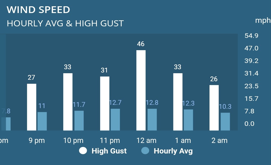
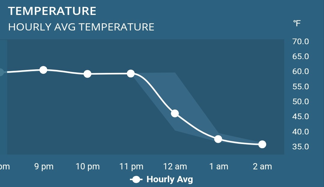
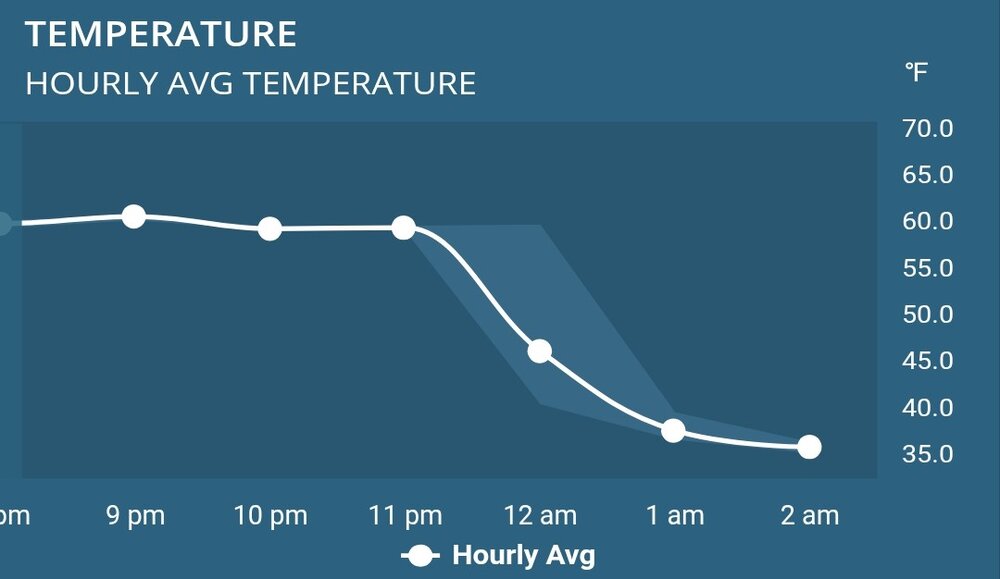
Didn't witness the pencil, but it seems to have brought a 46 mph gust. Plus, a cliff of a temperature drop in it's wake.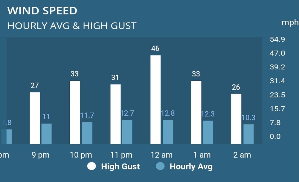
-
https://www.clarksfuneral.ca/obituaries/Roger-James-Smith?obId=47411042 Pretty bummed to read this tonight. I hadn't seen any posts from him for a couple of weeks. Unfortunately now I know why. Didn't quite know how to take him at first. A guy from BC commenting on our local weather as much as he did, but you could tell right away he was informed, courteous and interesting. Just a weather nut with a lot of knowledge that would engage with anyone. I'll miss his posts and contests. Proud to have won one of them this year. Who knew, 76 doesn't seem that old anymore. RIP Roger you will be sorely missed.
-

Pittsburgh/Western PA WINTER ‘25/‘26
TimB replied to Burghblizz's topic in Upstate New York/Pennsylvania
Official NWS obs was 6.3”. We officially got to warning level out of this thing. -
KBOS 170554Z 19029G54KT 62mph
-
I feel like every time we're under a warning winds under perform and don't meet criteria and the one time we're under an advisory we get to widespread warning
-
Eastern Mass likely in for a good burst of wind the next few hours. 60mph reported at Willimantic 58mph at BDL
-
59 mph here in Burlington CT