All Activity
- Past hour
-
It is weather! One's experienced weather in one's short life or extremely small period of record keeping is just...meh.
-
Yeah, most of the Time that is the case.
-
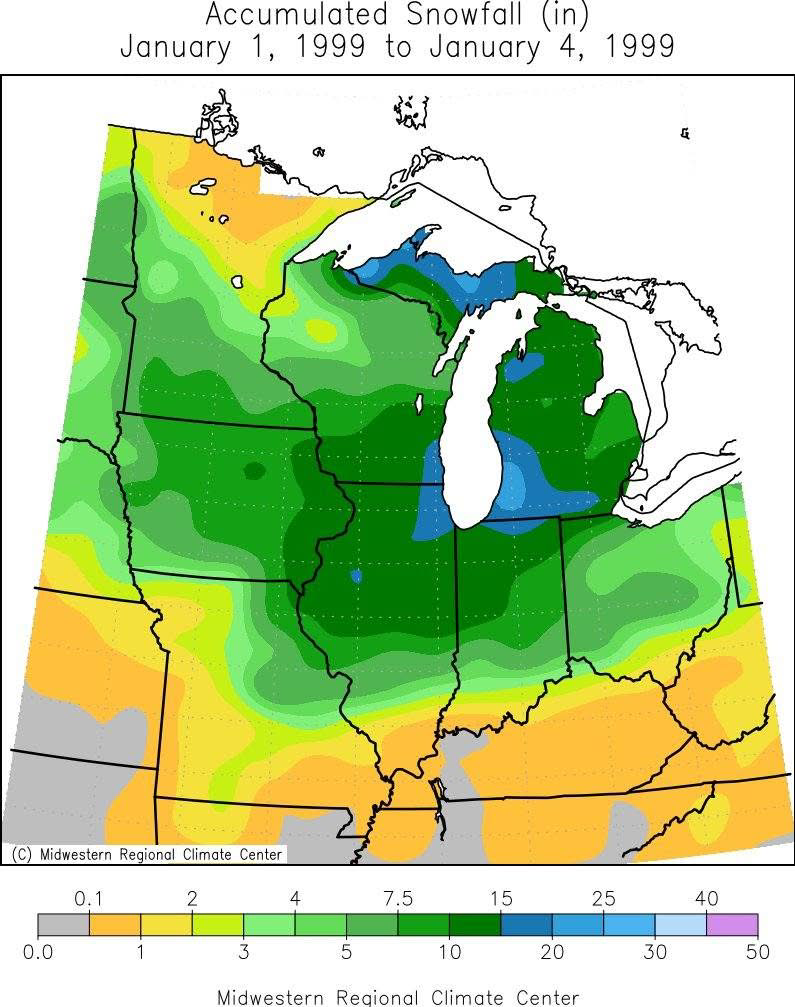
This will only be exacerbated by climate change. The warmth and mild weather for Central, south, and west US this season is incredible. Almost all snow outside of highest elevation has been east of the Dakotas and confined to Midwest and northeast. Very impressive warmth and mild weather. Pattern change isn’t until mid January so this will persist for some time
-
Sierran Cordillera is looking at yet another major winter storm tonight into Monday as at least four feet of additional pow will fall tonight and over the next few days. Ski Patrol needs to stay super sharp because as much as I hate avalanches, snow slide danger is going to become quite high, what with torrential snow accumulations and wind loading from banshee wind gusts especially at the crests. Snow cornices will be likely to develop with time and can easily break off and start unwanted snow slides that can come at the high cost of Ski Patrol personnel getting caught in them. They piled up 11 to 13 inches of additional pow last night, adding to the base snowpack. Snow will begin tonight and become quite heavy, winds will blow it around and by tomorrow Jan 3 2026 the Mammoth Resort will become a milkshake froth once again. Additional storms will smash right into the Sierra over the coming days. They are gonnabe quite busy in all the ski resorts in January. https://www.mammothmountain.com/on-the-mountain/mammoth-webcam/woolly-cam https://www.mammothmountain.com/on-the-mountain/mammoth-webcam/main-lodge
-

January 2026 regional war/obs/disco thread
mreaves replied to Baroclinic Zone's topic in New England
Do you have a neighbor with a snowmobile? -
well in fairness to them, the lottery is rigged so with their record last year, they still got sixth.
-
Happy anniversary to the greatest snowstorm of my life! Watching the snow pile up that day was something I’ll never forget.
-
So annoyed 2026 isn't good, first still sick now 2024 trucks 10 speed transmission messed up. Lol please hold off the snow for a little bit while i deal with this mess.
-
Some town in between Oswego and Syracuse is going to exceed six feet from the event going on there now. Winter storm warnings there tonight for 1-3 feet and snowfall rates 3-5 inches per hour. This is on top of 3-4 feet that has hit this area the last couple of days.
-
Looks like my high school GPA by semester.
-
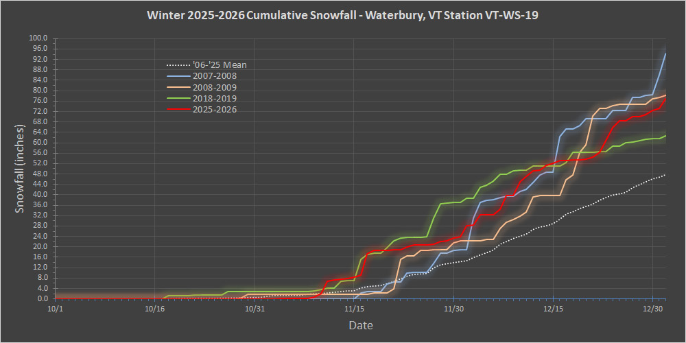
Data collection for December 2025 is complete, so we can see how it played out via the red trace in the updated snowfall progression plot below. Around mid-month, December had accumulated about 30 inches of snow, but the productive bread and butter pattern from the first half of the month slowed down a bit, and we hit that relative lull you can see after the 15th for about a week. That lull broke for the last week of the month though, which delivered roughly another 20 inches and ensured that December snowfall ultimately wound up above average. This season, the combo of November and December delivered between 70 and 80 inches of snow, which is solid, but still at the end of that +1 S.D. range. The plot nicely shows how the last week of the month allowed 2025-2026 to pull away from 2018-2019 (green trace). It looked like it was making a run for some of those top seasons, but it ultimately fell short of surpassing 2008-2009 (orange trace) and well short of catching 2007-2008 (blue trace). Overall though, this season has certainly had a solid start relative to average as the plot shows.
-
ATL 15 coldest winters since 1950-1/SN 1957-8 2.7” incl IP 1960-1 0.1” 1962-3 T + major ZR 1963-4 3.6” 1965-6 0.7” 1967-8 4.2” + major ZR 1968-9 2.2” 1969-70 0.6” 1976-7 1.0” + ZR 1977-8 0.3” 1978-9 4.6” IP + major ZR 1981-2 7.7” incl. IP + ZR 1983-4 1.3” 2009-10 5.3” 2010-1 7.1” Avg 2.8” SN/IP + ~avg ZR 2.8”/1.9” = 1.5 times the 1.9” normal ————— Mild winters with 2”+: only 5 (~20% of them) 1951-2 3.9” 1990-1 2.1” 1991-2 5.0” 2001-2 4.6” 2017-8 4.7” NN to cold winters with 2”+: 26 (~50% of them) NN and BN similar chance for 2”+ So, for ATL, having a mild winter (2+ F AN) significantly cuts down on the chance for normal SN. But NN doesn’t at all. Keep in mind that often much of ATL’s snow in a season comes from just one storm.
-
I just do not buy Phase 6 being cold
-

January 2026 regional war/obs/disco thread
HoarfrostHubb replied to Baroclinic Zone's topic in New England
Was hoping for a David Bowie gif -

January 2026 regional war/obs/disco thread
Sey-Mour Snow replied to Baroclinic Zone's topic in New England
Still will be the third biggest snowfall in Methuen this season -

January 2026 regional war/obs/disco thread
dendrite replied to Baroclinic Zone's topic in New England
The moon angle may hurt accums Saturday night -
Even from a mall parking lot
-
You probably regret 80% of your posts
-
NWS has temps progged above freezing here next week. Next weekend as of now looking wet, not white. Currently 21F.
-
Me during the great blizzard of 26 (speak it into existence) .
-
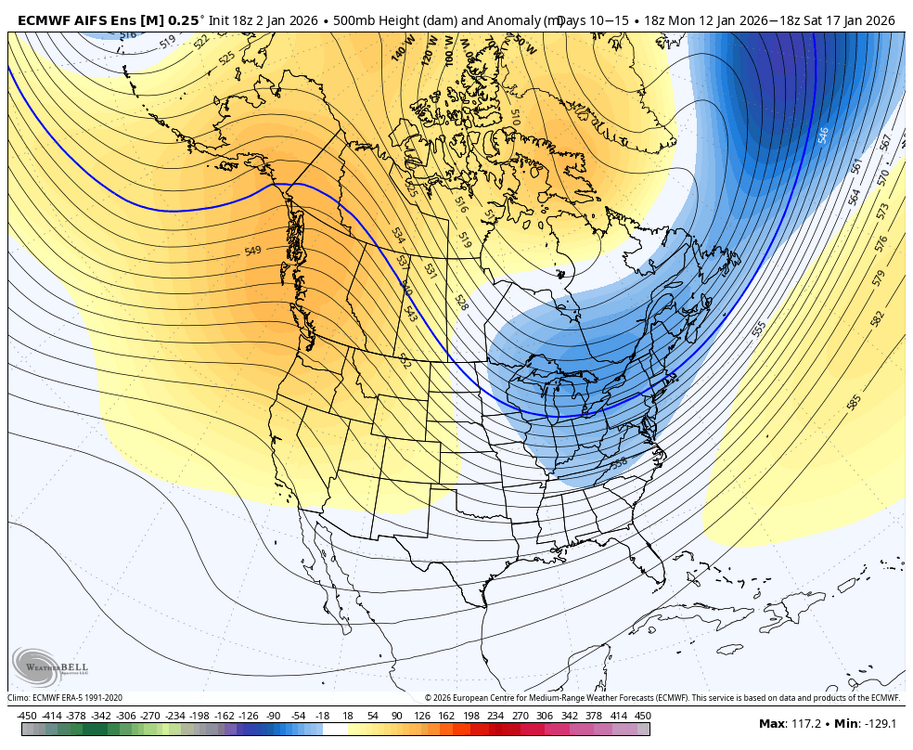
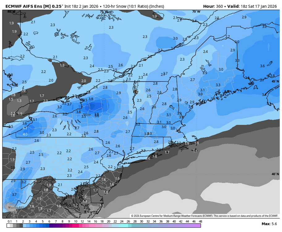
Here’s the day 10 to 15 AI Euro Ensemble look & snow for the period.
- Today
-
And if you don't like hobbies, set aside 2 weekends during the winter and drive to canaan/deep creek/snowshoe when the conditions are good out there. Getting that "fix" usually helps a lot.
-
It was spectacular...
-
@dailylurker your pics are all over my fb via Justin berk.
-
really starting to regret this post after the last few days