All Activity
- Past hour
-
Yeah. I think the mix can make it to your hood, but that signal on the initial WAA thump is absolutely incredible. The FGEN panels are nutty with a deep DGZ layer correlating with the same time frame. You’ll probably see some monster dendrites followed by clumped aggregates that will accumulate hard and fast before any flip. Should be a great storm down there, Bob!!
-

Possible Record Breaking Cold + Snow Sunday 1/25 - Tuesday 1/27
NJwx85 replied to TriPol's topic in New York City Metro
I’m not a 20 year old kid anymore. I’m a 40 year old man with 3 kids and a full time job. Don’t have the time I once had. I’ll do my best to chip in on this one though since it’s got blockbuster written all over it. -

Possible Record Breaking Cold + Snow Sunday 1/25 - Tuesday 1/27
TriPol replied to TriPol's topic in New York City Metro
If we dig any further, we'll truly bring Venezuela up here. -
Your wisdom makes me feel better about this. Let’s get this done. I’m nervous but cautiously optimistic.
-
14.5/7 at 10pm
-

January 2026 regional war/obs/disco thread
WinterWolf replied to Baroclinic Zone's topic in New England
Maybe he meant 7pm? 7 am sounds way to early? -
Guys, lets lock in. 0z suite time. We start with the ICON. Come on. You know the drill. Moderator @bncho is here to get you lot in order.
-
Possible Record Breaking Cold + Snow Sunday 1/25 - Tuesday 1/27
NJwx85 replied to TriPol's topic in New York City Metro
Long range NAM looks good.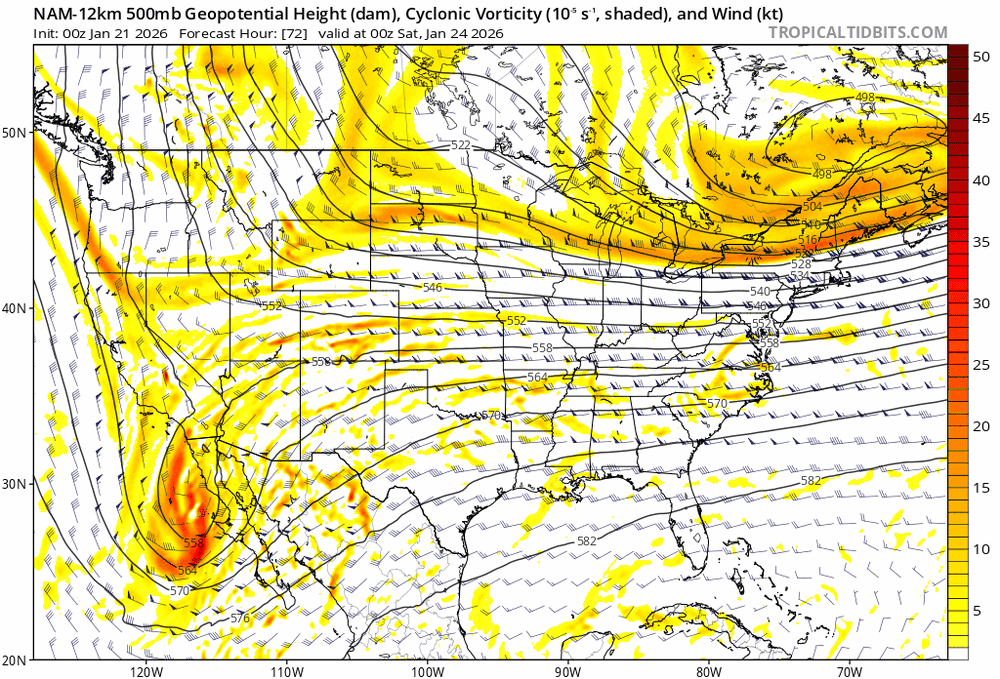
-
Icon through hour 60 has a more tilted N-S for the NS that opens up the SW and leads to it progressing east than its 18z run. 0z on top 18z below
-

E PA/NJ/DE Winter 2025-26 Obs/Discussion
Chadzachadam replied to LVblizzard's topic in Philadelphia Region
Warmest 10 degrees I’ve ever felt. Balmy out there -
is paul kocin still there lol?
-
I'm obviously no met, so pardon the uneducated question, but when you have warmer air aloft in situations like this coming weekend, doesn't that mean places like us at 3000-5000 feet elevation have MORE chance to get IP/ZR or pure rain since we are already in a "higher" part of the atmosphere vs say somewhere east of us at <500 ft elevation? It would seem that would put us in a more precarious situation than those East of us in cases like this. Am I thinking about this right? Thanks for the help trying to understand.
-
-
 @yanksfan and @allsnow used to do it and tony. used to be fun what happen to @Juliancolton
 -

January 2026 regional war/obs/disco thread
UnitedWx replied to Baroclinic Zone's topic in New England
7am? Now I need to go back and look again... crazy effed up day here, but i swear it was later -
SHOOT.. when you mix I feel like we end up mixing too.. can’t ignore the north trends no matter how positive I want to be. In reality though for both of us the WAA strip has hardly wavered for multiple runs now. Problem is the dreaded warm layer is starting to become a distinct reality. Hoping it keeps its mojo as we close in.
-
This is getting bad
-

Possible Record Breaking Cold + Snow Sunday 1/25 - Tuesday 1/27
NorthShoreWx replied to TriPol's topic in New York City Metro
I've seen great soundings for ratios, temps well down in the 20s, and gotten 12" of snow on 1.5" liquid in high winds. Mind you, the forecast soundings didn't verify perfectly, but the promise of high ratios was hollow. I think it happens more here because this is a windier place in a nor'easter; at least it is windier just off the deck with winds off the sound. -
I’m riding the NAM because it sounds like the model to jump on board with. Lol
-

January 2026 regional war/obs/disco thread
Go Kart Mozart replied to Baroclinic Zone's topic in New England
Big potential around the 30th too. We will probably need a separate thread for the Sunday-Monday event if we wake up to good 06zs tomorrow. -
Yeah, I wish there was more data. If the -34 was correct I would have to agree the NW NJ ice box spots might have been -40. I have always thought the -34 was too low though. Would like to know more about it. Good luck getting your weather station up. Shoot for Thursday....warmest day we'll see for a while.
-

January 25/26 Jimbo Back Surgery Storm
Prismshine Productions replied to Jimbo!'s topic in Southeastern States
Icon will becoming north Sent from my SM-S166V using Tapatalk -
January 2026 regional war/obs/disco thread
UnitedWx replied to Baroclinic Zone's topic in New England
I could see it coming in like a wall after it does. If this works out, that's a ton of moisture slamming into the area -

January 2026 regional war/obs/disco thread
Sey-Mour Snow replied to Baroclinic Zone's topic in New England
Most guidance is like 7am Sunday for CT, and these always start earlier -
Ha! Was watching that in a minimized window already.


