All Activity
- Past hour
-

2026-2027 Record-breaking El Nino
soadforecasterx replied to Stormchaserchuck1's topic in Weather Forecasting and Discussion
That was not the case on the east coast for last winter though. We had one of the coldest stretches since the 70s right after a massive winter storm. -

2026-2027 Record-breaking El Nino
EasternLI replied to Stormchaserchuck1's topic in Weather Forecasting and Discussion
Love that gradients were mentioned. Everything weather related needs gradients in order to operate, after all. I'm going to take this opportunity to add a PDO illustration to that same context. Because if you really dig deep into the research on it. You will find that the most important feature of that in a sst sense is the warm or cold tongue. Remember that when the PDO is in phase with enso, that enso effects are amplified. Out of phase, the opposite occurs to a degree. It is the increase or decrease in the gradients through latitude sst that contributes to this. You can see in the image below how a negative PDO(opposite of picture) in conjunction with El Niño offers a relaxed sst gradient by latitude. That makes it all the more interesting to see how this year evolves. -
August 28 1989: Baseball-sized hail pummels Pequot Lakes. For Friday, August 28, 2026 1898 - Torrents of rain accompanied by a furious wind upset the rain gage at Fort Mohave AZ. However, water in a wash tub set out on the mesa, clear of everything, measured eight inches after the 45 minute storm. (The Weather Channel) 1911 - Saint George, GA, was deluged with 18.00 inches of rain in 24 hours to establish a state record. (The Weather Channel) 1959 - Lieutenant Colonel William Rankin bailed out of his plane at a height of 46,000 feet into a violent thunderstorm, and lived to write about the 45 minute journey (which normally would have been a thirteen minute descent). He described it as one of the most bizarre and painful experiences imaginable. (The Weather Channel) (Note: Insane!!) 1971 - Heavy rains from Tropical Storm Doria caused devastating floods in central and northeast New Jersey resulting in 138 million dollars damage. In southeastern Pennsylvania, high winds downed trees and power lines, and in New York City, heavy rains flooded streets and subways. (David Ludlum) 1973 - An F4 tornado touched down near Canaan, New York, and moved to western Massachusetts. Three people were killed in West Stockbridge, Massachusetts when a truck stop was destroyed, and another person died in a ruined house nearby. 1986 - The temperature at Apalachicola, FL, dipped to 62 degrees to shatter their previous August record by four degrees, having tied their August record high of 99 degrees on the 2nd of the month. (The Weather Channel) 1987 - Severe thunderstorms broke the heat in the southeastern U.S. and the Gulf Coast Region, but not before seven cities reported record high temperatures for the date. The severe thunderstorms produced wind gusts to 80 mph downing large trees around Horse Shoe NC, and pelted southeastern Meridian MS with hail two inches in diameter. (The National Weather Summary) (Storm Data) 1988 - Tropical Storm Chris spawned a tornado near Manning, SC, which killed one person, and spawned three tornadoes in North Carolina. Chris produced one to two foot tides, and three to six inch rains, over coastal South Carolina. Severe thunderstorms in New York State and Vermont, developing ahead of a cold front, spawned a tornado which killed one person at Hector NY, produced tennis ball size hail at Brandon VT, and produced wind gusts to 80 mph at Lyndonville VT. (The National Weather Summary) (Storm Data) 1989 - Early morning thunderstorms in Nebraska produced 4.50 inches of rain around McCook, and 4.65 inches near Auburn and Brownville. Showers in Montana pushed the rainfall total for the month at Havre past the previous August record of 3.90 inches. (The National Weather Summary) 1990 - Between 3:15 p.m. and 3:45 p.m. a devastating F5 tornado ripped a 16.4 mile-long path through portions of Kendall and Will counties in northern Illinois. A total of 29 people were killed, and 350 more were injured. An estimated $160 million in damages occurred. The tornado's path width ranged from 200 yards to half a mile. A total of 470 homes were destroyed, and another 1000 homes were damaged. Sixty-five thousand customers lost power. 2005 - Hurricane Katrina attained Category 5 status on the morning of August 28 and reached its peak strength at 1800 UTC that day, with maximum sustained winds of 175 mph and a minimum central pressure of 902 mbars (26.6 inHg). Observances: 28 Fri March on Washington 28 Fri Rainbow Bridge Remembrance Day 28 Fri Bow Tie Day 28 Fri World Sanskrit Day 28 Fri Crackers Over The Keyboard Day 28 Fri National Bow Tie Day 28 Fri National Cherry Turnover Day 28 Fri Power Rangers Day 28 Fri Race Your Mouse Around the Icons Day
-
Good thing you chose meteorology over politics! Lol
-
Didn't matter with all that cloud cover last night.
-

2026-2027 Record-breaking El Nino
bluewave replied to Stormchaserchuck1's topic in Weather Forecasting and Discussion
Last season was the best this new much warmer climate could do as compared to the 95-96. More warmth was a factor in the NAO reversing so quickly in March as corals studies have found bigger NAO and AO swings from one state to another as the climate has warmed. Much less available cold made last winter the 2nd warmest for the CONUS. -

Augdewst 2026: Summer's Last Stand
Brian5671 replied to Prismshine Productions's topic in New England
Happy to miss the rains for the most part on this one. Finally drying out a bit here. 76 now waiting for the front to clear later today and wow didn't realize the political forum was back up...LOL -
Lightning and thunder last night 9:30 - 10 but zero rain.
-
FWIW, the GFS this morning redevelops Dolly's remnants in the GOM and gives Texas a hurricane. Thanks for posting this. After a careful look at the 6Z GFS, including the progged vorticity for various levels of the atmosphere, it appears to me like this may be a combo of Dolly’s remnants and additional vorticity similar to the vorticity that the last 4 full UKMET runs have shown off the SE coast developing into a sfc low (TC on last 3 runs).
-
E PA/NJ/DE Summer 2026 Obs/Discussion
Albedoman replied to PhiEaglesfan712's topic in Philadelphia Region
For the 100th time macungie got crap. The outflow boundary killed lehigh county once again. The story of this summer The haves and have not. -
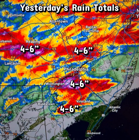
An uninspiring 0.20” Thursday but it did get me over 4” for August (Columbia)
-

Augdewst 2026: Summer's Last Stand
Brewbeer replied to Prismshine Productions's topic in New England
anything to rationalize the irrational -

Augdewst 2026: Summer's Last Stand
PhiEaglesfan712 replied to Prismshine Productions's topic in New England
Name changes are more common than you think. Just look at all the pro sports stadiums. You don't realize it, but their name changes hand often, and sometimes silently. As they say, in this country, if you pay enough... -
Around this time in 2024 we had a tropical remnant system headed our way and a massive precip forecast. Instead the bulk of the rain refused to go north of Richmond.
-
Storm got to my doorstep yesterday then changed its mind and just disappeared into thin air. lol
-
Looks like a great weekend coming up! Finally drying out a bit around here.
-

Augdewst 2026: Summer's Last Stand
OldSkool replied to Prismshine Productions's topic in New England
Tappan Zee bridge changed to Governor Mario Cuomo Bridge. -

E PA/NJ/DE Summer 2026 Obs/Discussion
Ralph Wiggum replied to PhiEaglesfan712's topic in Philadelphia Region
-

Occasional Thoughts on Climate Change
Typhoon Tip replied to donsutherland1's topic in Climate Change
There's no debate. The objective reality is that this was caused by destabilization of geological mass (ice/rock/water) failing and thus accelerating from elevation. The +flux (which means increase) of melt water destabilizes the previous the geologic structural integrity that previously held glacial lake mass, and potentially destabilizing land mass(es) made to fail, at bay. A collapse was inevitable. Occurring at significant elevation provided excessive momentum - a structural failure that went on to become mass-gaining. The land, ice, or both-slide probably inundated and ultimate pushed out glacial lake, and then en masse accelerating down the highly sloped region... Subsequently gaining more mass most every time in swept through and acquired any alpine lakes and kettle nadirs that may have been transiently filled with seasonal melt ...etc etc.. along the way. Until there's amassed biblical torrent with so much crushing momentum and weight it was capable of setting of seismology detection. That's it as far as cause. The rest is humanity building civility in the fertile/convenience of an alpine river valley, thus inherently placed in potential harms way. It is important to mention that anytime you place civility under a geological feature, eventually, given time, something like this is going to happen. It is perhaps of even more importance to mention, the acceleration of climate change is going to bring about this sort of thing with increased frequency. This is so for a lot of geo-physical reasons; each case analyzed precisely. In this case, the chain of events described above would likely occur at some point in geology, anyway, but the relationship to rapidly non-restoring climate change is directly provable/moved it up in geological history. Everywhere around the world where these risk zones that can be sought out and identified should be addressed. Now. But won't be... so that people can instead get off on these marvelously dystopian horror shows, watching what are likelier than not to become regular matinees as we go on blithely in denial or just stupidly forward in (humanity's end time?) history. Just wait until Greenland goes on ahead does the impossible whence its land-locked ice slides on off into the ocean, setting off a 22 ft global tsunamis that doesn't run back out to sea after it sweeps in for lunch and eats 3.8 billion lives one single afternoon. Or Antarctica... Luckily for humanity huh, these regions are "presumed" be slower contributors to sea-level rise. Weee. But, no one thought an entire planet and all it its integrated systems, could up and rise a half degree C in the spring of 2023 ... and stay there, either. Has anyone else paused in a moment of startling realization that we are living in an era where the impossible actually happens? By the way, the Greenland massive landslide in September 2023, remember? The one that set off a 200M mega-tsunami through the Dickson Fjord, it was also seismically detectable, worldwide for that matter. The planet rang like a bell for nine days. -
FWIW, the GFS this morning redevelops Dolly's remnants in the GOM and gives Texas a hurricane. Yeah should be interesting if/when it opens back into a wave, will NHC immediately put an orange/red back onto the TWO.
-
True about the models, but I don’t think that was a real can kick. If October is abnormally dry though, I’ll concede
-
I could get behind the petition to rename Canadian geese as Donald ducks.
- Today
-
Great pic! I'd send one, but it would have just been of the cloud deck and rain. Picked up 1.49" with LOTS of T&L between 10 pm and 1 am. Sitting at 5.28" for the month.
-
Why is it every time the models show a wet pattern coming up it collapses a week before it starts? Will the niño ever kick in? Or is this nw dominated pattern the new normal?
-
Punting from September to October. There were signs that September was going to turn wet but over the course of this week the modeling for it completely collapsed.