JJBASHB
-
Posts
852 -
Joined
-
Last visited
About JJBASHB

- Birthday 11/09/1987
Recent Profile Visitors
7,105 profile views


-
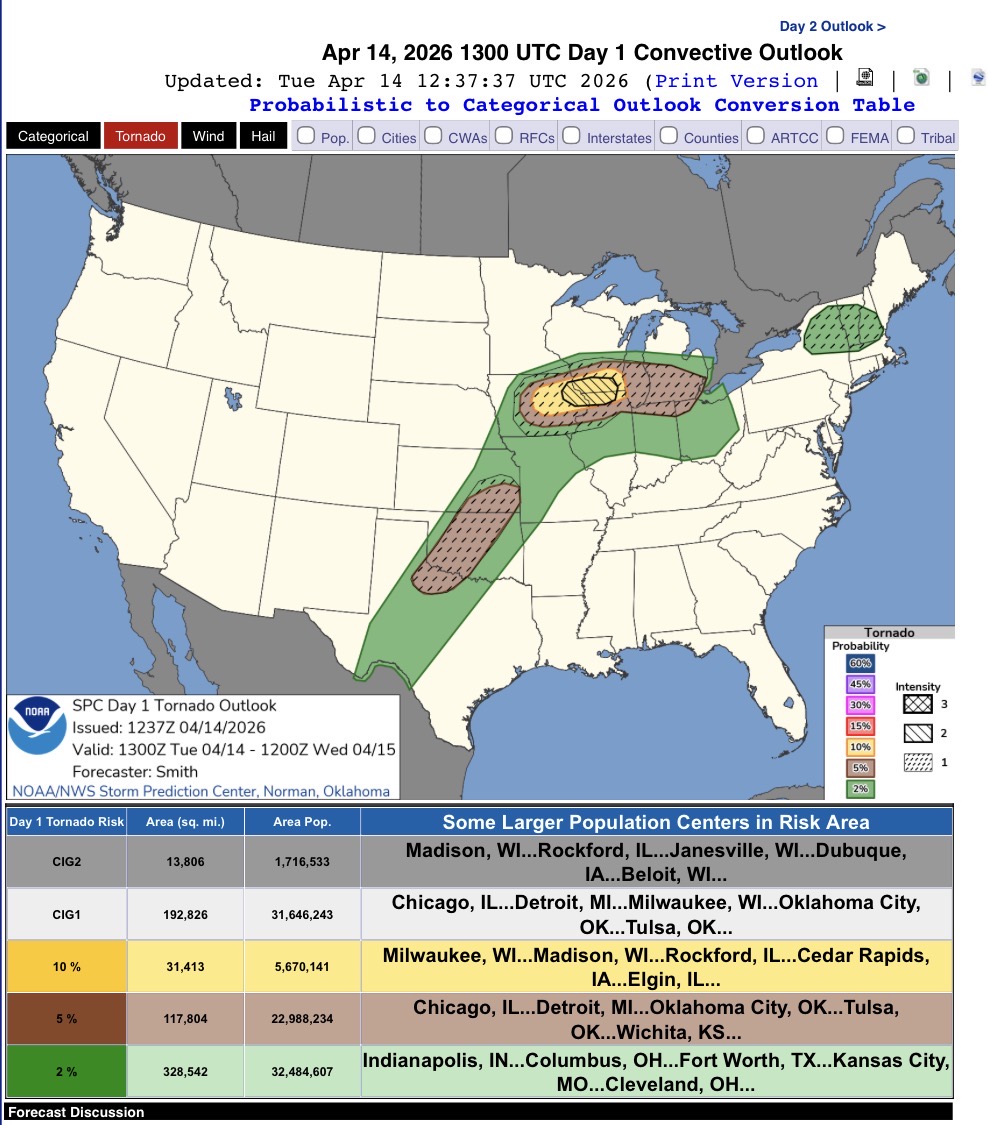
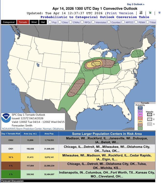
2% Tornado ...Northeast... A low-amplitude disturbance associated with an ongoing MCS near Lake Ontario this morning will move east into the Northeast during the day. Cloud breaks and low-level warm/moist advection will contribute to a destabilizing airmass by midday. Veering and strengthening winds with height will support storm organization, including the potential for supercells. Eventually a band of storms is forecast to evolve by mid-late afternoon with wind damage being the primary risk. Have introduced low hail/tornado probabilities to account for hazards associated with supercells.
-
First slight risk!
-
Sun!!!
-
We got a bit more over by the Bedford line, around 1.75” total. Sleet with a layer of snow on top.
-
Kinda looks like the sleet line is headed northeast again on CC? Heavy sleet in my part of MHT.
-
Sleet line has made it to MHT. Not an official measurement but ~4” before the change.
-
One of the few situations where MHT might be the envy of New England. Up to 37. Lots of dripping but mostly sun related as the dp is still in the teens. Kind of a perfect day to get outside. Not too wet from melting but the sun feels great.
-
Clipper Fires In Wednesday Feb 25 Disco/ Obs
JJBASHB replied to Damage In Tolland's topic in New England
Definitely was generous with my eye measurement earlier. Only an 1” in Manchester -
Clipper Fires In Wednesday Feb 25 Disco/ Obs
JJBASHB replied to Damage In Tolland's topic in New England
-SN bordering on SN despite the progressive radar. It’s like the snow form of misery mist. Lots of tiny flakes. Looks like 1.5” -
Clipper Fires In Wednesday Feb 25 Disco/ Obs
JJBASHB replied to Damage In Tolland's topic in New England
Steady light snow, surfaces disappearing fast. -
Clipper Fires In Wednesday Feb 25 Disco/ Obs
JJBASHB replied to Damage In Tolland's topic in New England
First flakes. -
Clipper Fires In Wednesday Feb 25 Disco/ Obs
JJBASHB replied to Damage In Tolland's topic in New England
Virga despite the heavier echos overhead. -
"Don’t do it" 2026 Blizzard obs, updates and pictures.
JJBASHB replied to Ginx snewx's topic in New England
Snow is drifting south of the heaviest radar returns up here. MHT with 0.25mi vis and gusting to 37mph. It must be incredible down in RI/SE Massachusetts. Someday I’ll get down there for one of these. -
"Don’t do it" 2026 Blizzard obs, updates and pictures.
JJBASHB replied to Ginx snewx's topic in New England
This consolation band has been fun.
-
"Don’t do it" 2026 Blizzard obs, updates and pictures.
JJBASHB replied to Ginx snewx's topic in New England
.25mi vis and gusting to 30 at MHT last observation. Getting closer to Blizzard conditions.