All Activity
- Past hour
-
.thumb.png.4150b06c63a21f61052e47a612bf1818.png)
Spooky Season (October Disco Thread)
HIPPYVALLEY replied to Prismshine Productions's topic in New England
Earlier today, somebody pointed out in the main hurricane thread, that although it would be biblical rains, the Jamaican mountains have very heavy vegetation, which will at least help prevent severe mudslides. Obviosly, still going to be crazy water issues. Brutal winds but at least Jamaica has a lot of cement buildings. -

Major Hurricane Melissa - 909mb - 175mph
WxWatcher007 replied to GaWx's topic in Tropical Headquarters
Yep. My bad lol -
And the 5am and 11pm
-
Not sure how much lower pressure the atmosphere can support down there. Assuming it can go close to 900mb. Just a sick setup. The depth of the warm water in that area is always off the chart.
-

Spooky Season (October Disco Thread)
WinterWolf replied to Prismshine Productions's topic in New England
Most of them will be turned into mud slides by tomorrow afternoon. -

Spooky Season (October Disco Thread)
Go Kart Mozart replied to Prismshine Productions's topic in New England
Answer to my own question: The Blue Mountains rise to these elevations from the coastal plain in the space of about 16 kilometres (9.9 mi), thus producing one of the steepest general gradients in the world.[1 This is going to really suck. -

Major Hurricane Melissa - 909mb - 175mph
hawkeye_wx replied to GaWx's topic in Tropical Headquarters
Latest Google track
-
WB 18Z AI

-
Spooky Season (October Disco Thread)
Go Kart Mozart replied to Prismshine Productions's topic in New England
Jamaica has some significant mountains, right? -
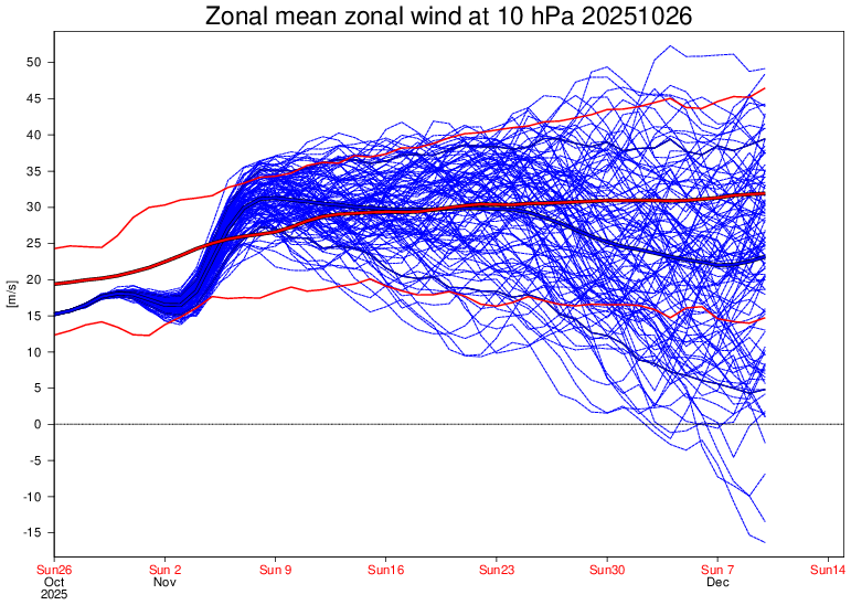
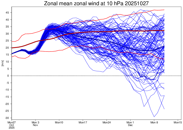
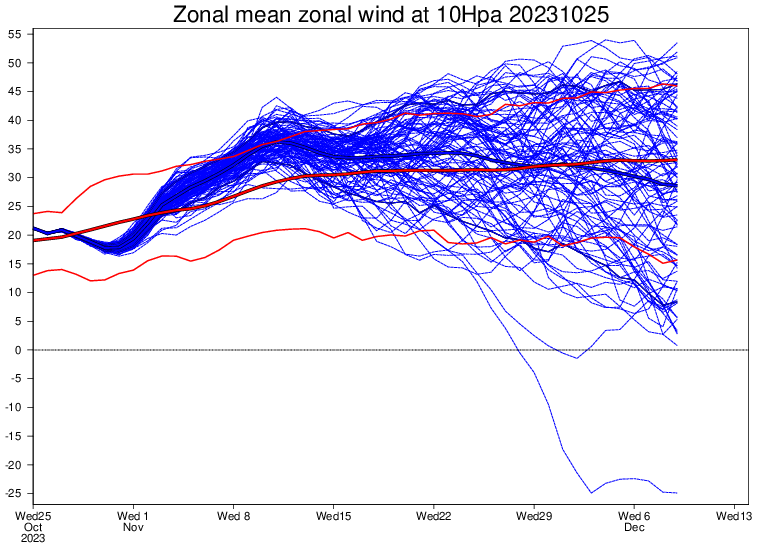
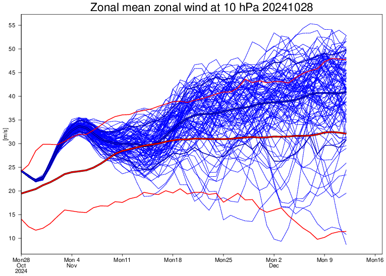
Today’s Euro Weeklies run mean has an even weaker SPV with only 8 of the 42 days’ mean stronger than normal, and it even includes 15% of members with a very early major SSW, by far the most yet of any run this season! Note that the mean Thanksgiving through Dec 11th of 2025 SPV is only ~20 vs normal of 31, which would be the weakest for that period since 2019-20: Compare the above to the same time last year: 40 of the 42 days’ mean stronger than normal along with ZERO members with a major SSW: Note that the mean Thanksgiving through Dec 12th of 2024 was up at ~37 (it verified to be way up at ~45) Now compare to the same time two years ago: 30 of the 42 days’ mean stronger than normal with only 2% with a major SSW: Note that the mean Thanksgiving through Dec 9th of 2023 was ~31 (it verified to be ~34): In summary, this post shows that the 100 member Euro Weeklies mean is suggesting a mainly weak SPV in late Nov and early Dec, which would compare to a very strong SPV for the same time in 2024 and a slightly stronger than normal SPV in 2023. Even if we assume that the 2025 prog is biased modestly too negative, a bc adjustment would still be progged pretty weak after a bias adjustment (~25) and would be way below 2024’s actual of 45 and significantly below 2023’s actual of 37. @mitchnick@snowman19
-
The 5 pm and 8 pm NHC cones are identical, as they usually are, as I don't recall them ever updating those maps for the intermediate advisories. Files too large to paste here, which surprises me. https://www.nhc.noaa.gov/archive/2025/MELISSA_graphics.php?product=3day_cone_with_line
-
Past ~30ish hours of just a wobbling crawl.
-
Major Hurricane Melissa - 909mb - 175mph
WxWatcher007 replied to GaWx's topic in Tropical Headquarters
Right for those lurking/not familiar with tropical—the intermediate advisories do not have a cone change. That happens at 5am, 11am, 5pm, and 11pm ET when the full advisory is issued. That’s also when we get the technical discussions. In addition, the width of the cone is based strictly on historical track error, which is defined before the season. What you’re seeing tonight is not uncommon at all for imminent coastal threats, especially powerful ones. They can drift/meander/wobble. The best way to track the longer term motion is to use radar and recon center fixes. All the way until landfall. -

Spooky Season (October Disco Thread)
dendrite replied to Prismshine Productions's topic in New England
Don’t worry about a thing. Cause every little thing is gonna be alright. -

Major Hurricane Melissa - 909mb - 175mph
SchaumburgStormer replied to GaWx's topic in Tropical Headquarters
Insane symmetry and cold tops. Wow -
It’s the best its looked yet. Unreal.
-
Look at the symmetry. It's got to be strengthening.
-
Hes not gone. Unless its by choice. He was given a much needed break.
-
It isn't updating because there isn't a new cone....
-
A strong NAO blocking regime is in place and will persist into early November. As a result, an extended period of cooler than normal weather will prevail through the end of the month. Tomorrow will be another cool day. Temperatures will top out in the lower and middle 50s across much of the region. Many locations outside of New York City will again see readings start in the 30s. Hard freezes are again likely well north and west of New York City. The unseasonably cool weather will continue through at least the middle of the week. Rain will likely arrive Wednesday night or Thursday. A general 1"-3" rainfall is likely late Wednesday night through Friday. There remains uncertainty about the area of heaviest rainfall. The storm will be followed by a continuation of cool weather. The ENSO Region 1+2 anomaly was +0.3°C and the Region 3.4 anomaly was -0.6°C for the week centered around October 22. For the past six weeks, the ENSO Region 1+2 anomaly has averaged -0.07°C and the ENSO Region 3.4 anomaly has averaged -0.48°C. La Niña conditions will likely continue through mid-winter. The SOI was +23.33 today. The preliminary Arctic Oscillation (AO) was +1.351 today. The NAO was -1.497. Based on sensitivity analysis applied to the latest guidance, there is an implied 70% probability that New York City will have a warmer than normal October (1991-2020 normal). October will likely finish with a mean temperature near 58.2° (0.3° above normal). Supplemental Information: The projected mean would be 1.3° above the 1981-2010 normal monthly value.
-
Looks like tidbits is having issues. Server overload it seems.
-
Certainly looks like it. Let's see if this is the beginning of a change towards a north/north east move.
-
Just rage engagement farming.
-
Here we go Jamaica. Hit a wall, expect N/NNE turn shortly. Also the best its ever looked on satellite.
-
Spooky Season (October Disco Thread)
WinterWolf replied to Prismshine Productions's topic in New England
Like what Maria did to Puerto Rico, and Dorian did to the Bahamas.