All Activity
- Past hour
-

2026-2027 Record-breaking El Nino
roardog replied to Stormchaserchuck1's topic in Weather Forecasting and Discussion
Yeah. There’s some questionable temp records from the early days of record keeping for sure. -
Broadleaf. Shade has died out, became too expensive to grow here.
-
Yeah chances of heavy rain have dropped
-

E PA/NJ/DE Summer 2026 Obs/Discussion
Birds~69 replied to PhiEaglesfan712's topic in Philadelphia Region
66F/DP 61F <40 days...
-
Forunately this will not come to fruition this weekend in the tri-state area.
-
 More strawmen! 1) The 1946-direction of temperature change. "If the station relocated onto a substation with massive transformers and high loads, the raw record should have jumped warm". Built on a mechanism I never asserted, but you attributed to me and then rebutted. 2) "Unverifiability is being offered as a reason for confidence". Same false premise as #1. 3) "Your mechanism implies a ramp, PHA fits steps — wrong shape". same false premise as #1. 4) "you claimed to know the direction/magnitude". Not something I ever said. I have offered a satellite-based 30 m pixel surface temperature map that showed progressively cooler station siting conditions for the day the satellite data was collected. Pretty neat I think. 5) The "documented" vs. "thermal zoo" contradiction charge. Not something I have claimed. I have said repeatedly, and will repeat now, that the I have fully documented the breaks as valid and necessary. I have never claimed to know or documented the precise direction or magnitude of breakpoints--that is your reading. To document the timing, direction and magnitude of each break I would need to have precise and accurate microsite details, precise and accurate knowledge of the instruments, and a precise and accurate records of every interaction of the observer with the instrument--probably much more--throughout the station's record. Beyond ridiculous.
 -
 Cheap generic Viagra: MenCare - cheap viagra
 -

Augdewst 2026: Summer's Last Stand
Damage In Tolland replied to Prismshine Productions's topic in New England
Looks slightly above to above normal thru the 31st. The coming week cool vanished. Something to keep in mind moving forward -
Aug dep through the 14th (first two weeks) PHL: +4.6 JFK: +2.9 ISP: +2.9 EWR: +2.8 LGA: +2.4 NYC: +1.1
-
Records: Highs: EWR: 99 (1988) NYC: 97 (1988) LGA: 97 (1985) JFK: 98 (1988) Lows: EWR: 54 (1964) NYC: 54 (1964) LGA: 59 (1964) JFK: 57 (1964) Historical: 1787 - Tornadoes were reported in Connecticut, Rhode Island, Massachusetts, and New Hampshire. Wethersfield CT was hard hit by the tornado outbreak. (David Ludlum) 1886: This tornado was estimated to be an F3 and moved northeast from 5 miles southwest of Newark, SD through town and into North Dakota. Only three buildings were reportedly undamaged at Newark, and a bartender at a saloon was killed. Three people died in two homes on adjoining farms two miles southwest of town. A saddle from a Newark stable was carried for a half mile. In North Dakota, homes and barns was damaged along the Wild River. (Ref. Wilson Wx. History) 1946 - Saint Louis, MO, was deluged with a record 8.78 inches of rain in 24 hours. (The Weather Channel) 1950: In 45 years of Hawaiian meteorological records, a hurricane had never affected the islands. On this date, Hurricane Hiki was moving north of the islands. Residents held their breath when the storm turned southwestward. Fortunately, the storm resumed its westward course and missed the islands. The highest wind speed recorded was at Kilauea Lighthouse, Kauai at 68 mph. (Ref. Wilson Wx. History) 1967 - The sundance fire in northern Idaho was started by lightning. Winds of 50 mph carried firebrands as much as ten miles in advance to ignite new fires, and as a result, the forest fire spread twenty miles across the Selkirk Mountains in just twelve hours, burning 56,000 acres. The heat of the fire produced whirlwinds of flame with winds up to 300 mph which flung giant trees about like matchsticks. (David Ludlum) 1969: Camille became a hurricane south of Cuba and entered the Gulf of Mexico as a major hurricane with winds of 115 mph. (Ref. AccWeather Weather History) 1971: Some of the worst flooding that ever occurred in western north Texas happened on this date. Heavy rain began on the 14th, but the worst of the rain and most of the flooding was on this date. On that day, rainfall amounted 4 to 11 inches. The Wichita River, on the northwest side of Wichita Falls, TX crested at its highest level in 30 years. At least 10 families were forced to evacuate their homes along the river as the waters rapidly rose. The river also rose so high that its swift-flowing waters undercut several streets, causing them to collapse. The official rainfall at the National Weather Service Office in Wichita Falls was 4.52 inches, making this the wettest August day ever observed in the city. (Ref. Wilson Wx. History) 1977: Lightning struck a cement well covering near Mankato, MN, causing shattered pieces of concrete to be blown over 30 feet, damaging cars. (Ref. AccWeather Weather History) Hurricane Doreen tracked north-northwest along the west coast of Baja California, dissipating over the coastal waters. Areas of southern California received at least two inches of rain with up to 8 inches in the mountains on this date through the 17th. Debris flows and flooding from Henderson Canyon into the Borrego Springs De Anza area damaged 100 homes. Mud flows grew to five feet deep. Flooded roads resulted in desert areas. Four people died and damage was set at $25 million dollars. (Ref. Wilson Wx. History) 1979: Early season chill across the Midwest and East produced record low temperatures for the date including: International Falls, MN: 33°, Grand Forks, ND: 36°, Madison, WI: 37°, St. Cloud, MN: 39°, Fargo, ND: 43°, La Crosse, WI: 43°, Dubuque, IA: 45°, Peoria, IL: 45°, Indianapolis, IN: 45°, Mansfield, OH: 46°-Tied, Moline, IL: 47°-Tied, Akron, OH: 47°- Tied, Youngstown, OH: 47°-Tied and Cincinnati, OH: 49°. (Ref. Wilson Wx. History) 1983 - Hurricane Alicia formed on this day and was the costliest tropical cyclone in the Atlantic since Hurricane Agnes in 1972. It struck Galveston and Houston, Texas directly, causing $2.6 billion (1983 USD) in damage and killing 21 people. This storm was the worst Texas hurricane since Hurricane Carla in 1961. Also, Alicia was the first billion-dollar tropical cyclone in Texas history. 1987 - Thunderstorms developing ahead of a sharp cold front produced severe weather in the Upper Midwest during the afternoon and evening hours, with Minnesota and eastern South Dakota hardest hit. A thunderstorm in west central Minnesota spawned a tornado at Eagle Lake which killed one person and injured eight others. A thunder- storm in eastern South Dakota produced softball size hail at Warner. (The National Weather Summary) (Storm Data) 1988 - Thirty five cities in twenty states in the north central and northeastern U.S. reported record high temperatures for the date, including Lamoni IA and Baltimore MD, where the mercury hit 105 degrees. Temperatures 100 degrees or above were reported in twenty-two states. Pierre SD was the hot spot in the nation with a high of 114 degrees. Bluefield WV reported eight straight days of record heat. (The National Weather Summary) 1989 - Evening thunderstorms in eastern New Mexico produced wind gusts to 66 mph at Clovis. Evening thunderstorms in West Texas produced baseball size hail around Hereford, Dimmitt, Ware and Dalhart. (The National Weather Summary) (Storm Data) 1993: Slow moving thunderstorms produced torrential rain across Mower County, MN. Rainfall exceeded 4.00" over most of the county with the highest total of 10.25" at Adams, MN. Significant flooding occurred within the city of Austin, MN, where 1,000 homes suffered water damage. The Cedar River in Austin rose rapidly out of its banks through the day. It crested at 21.3 feet, 6.3 feet above flood stage. (Ref. Wilson Wx. History) 1994: Tropical Storm Beryl formed in the northeast Gulf of Mexico and moved slowly east northeast, crossing the Florida panhandle coastline near Panama City. Beryl greatly added to the woes of people who were still recovering from Tropical Storm Alberto in July. At landfall the maximum sustained wind was estimated at 60 mph. The greatest rainfall total of 10.69 inches were observed at Apalachicola, but higher values likely occurred to the east of this location. Beryl weakened to a tropical depression as it moved northeast into extreme southwest Georgia at early on the 16th. There were no deaths and only 1 injury directly attributable to Beryl and damage was estimated at $5.9 million dollars. (Ref. Wilson Wx. History) 2004: Severe flooding in Death Valley National Park in California caused extensive flooding. The flooding completely washed away several miles of roadway and caused damage to several rest areas. Two people traveling along Highway 190 were caught in the flooding and killed. Damage was estimated at $20 million dollars and took 3 months to completely repair the damage. (Ref. Wilson Wx. History) (Ref. WxDoctor)
-
74 / 58 mostly sunny, low - mid 80s today. Clouds oush back sunday with showers/storms some heavy downpours mainly in the PM. Warmer period 8/17 - 8/19-20 the warm spots could touch a stray 90. Near normal 8/19-20 through the 23 before the Atlantic ridge builds back a more southerly warmer/humid flow beyond there.
-

2026-2027 Record-breaking El Nino
LakePaste25 replied to Stormchaserchuck1's topic in Weather Forecasting and Discussion
Definitely true for temperature records too. There’s no possible way that Phoenixville, PA hit 111 in the early 1900s. Many of these should be tossed IMO. -
AI can do that easily. I will put it to work. Should we look at daily, monthly, or annual? Tavg, or Tmin and Tmax?
-

Augdewst 2026: Summer's Last Stand
dendrite replied to Prismshine Productions's topic in New England
DJFM But yeah, mostly just brief warmups between COC shots. I wouldn’t call it cold though. Summer and the sun angle are quickly fleeting though. -
Severe Storms mainly south of us Sunday - most of the flooding rains will occur south of us also--BUT still have to monitor that situation for changes as PWATS are high over 2 .
-
Cheap generic Viagra [url=https://mencarevirtual.shop/#]MenCare[/url] Viagra online price
- Today
-

Chester County PA - Analytical Battle of Actual vs. Altered Climate Data
chubbs replied to ChescoWx's topic in Climate Change
Yes, Reading and West Chester are stable in the 1929 to 1960 period and I am going to add Reading to my analyses. A couple of comments. As I said above looking at shorter time periods significantly expands the list of reference stations for individual station breaks as all stations are stable between the station breaks. Second, there is no need to restrict to short distances from Chester County. Weather station data is well correlated over hundreds of miles. An interesting first step would be to check how far good correlation with Chester County extends. -
Chester County PA - Analytical Battle of Actual vs. Altered Climate Data
chubbs replied to ChescoWx's topic in Climate Change
Lets look at the big picture. All four estimates you've listed agree that Phoenixville experienced spurious cooling in 1948. Better to recognize that Phoenixville had a cooling move vs ignoring the move and using the raw data. However things aren't as uncertain as the four numbers make it seem. First the BEST estimate is 1.58F on Mike's chart not 1.88F, closer to NCEI. Second If you look at Mike's charts there are many small differences between NCEI and Berkeley that cancel out over a longer time period. I don't see a big difference in the NCEI and Berkeley climate history of Chester County. Third, I wouldn't expect my estimates to be that accurate. I haven't taken the time to optimize my approach and more importantly there are many other stations besides West Chester and Coatesville that can be used to estimate the impact of Phoenixville's move. I say the NCEI method is bullet-proof because it has a strong scientific foundation. Science says that there is a strong correlation in year-to-year temperature changes over a wide area and that's exactly what I have found. This chart is an example. These stations are well correlated at the time of the Phoenixville move indicating that they all can be used to estimate the timing and impact of the Phoenixville move. Moreover, I have only scratched the surface, there are just the ones that had the time to check.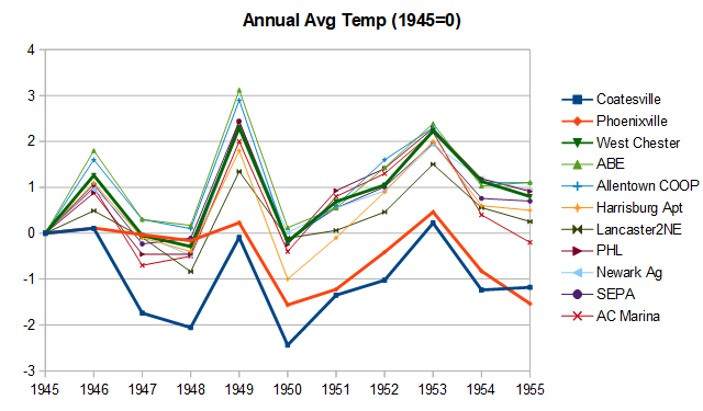
-
Understood, but seems LWX disagrees in their morning AFD? Or am I misreading? In addition to any heavy rain threat is the potential for bands of strong to severe thunderstorms. Increased flow down into the low levels would be favorable for organized line segments capable of mixing down damaging wind gusts in any organizing cold pools. The saturated profiles could result in water loading downdrafts, though the lack of mid-level dry air may keep DCAPE low putting a ceiling on just how high damaging wind gusts can get (most likely in the 50-65 mph range). The increased low- level flow and SRH coupled with moist profiles could lend to the threat of a few tornadoes as well. Although the prospect of early morning clouds and precip may at first glance seem to preclude a higher potential for heating and severe weather later in the day, the high low-level moisture content coupled with steady height falls aloft means that heating will not need to be as robust to result in sufficient CAPE for strong to severe convection, especially given the shear that will be present. Some severe weather or flood threat may persist into the night given the above listed factors.
-
Cheap generic Viagra online: Buy generic 100mg Viagra online - Buy generic 100mg Viagra online
-

Central PA Summer 2026 Discussion/Obs Thread
Mount Joy Snowman replied to Voyager's topic in Upstate New York/Pennsylvania
Low of 63 with a beautiful day upon us before the rain comes tomorrow. Taking some friends out on the river today with the kids. Should be a swell time. -

Central PA Summer 2026 Discussion/Obs Thread
pawatch replied to Voyager's topic in Upstate New York/Pennsylvania
59 degrees this morning…Beautiful out. -
When's the torch again? Hope I didn't miss it.
-
Did you happen to arrive to this stance on happen by happenstance?
-

Central PA Summer 2026 Discussion/Obs Thread
mahantango#1 replied to Voyager's topic in Upstate New York/Pennsylvania