All Activity
- Past hour
-
Oh, I get it! But it's like whiplash when a model comes out and one guy is "BULLSEYE!!" and the next is "Oh no!!! We lost it!!" Not complaining, just a cool little quirk of this thread.
-
Point and click are basically the NBM fed into a forecast graphic computer system. These are the model runs that went into the 18z NBM for snowfall at hour 42. So it's made from mostly ensemble members, short range models, and hasn't incorporated any data from the 12z/06z Euro at all that I can see. Model Date Cycle Projection Valid Date ECMWFE P1 20260129 0 60 2026013112 GEFS P27 20260129 6 54 2026013112 GEFS P26 20260129 6 54 2026013112 GEFS P25 20260129 6 54 2026013112 GEFS P24 20260129 6 54 2026013112 GEFS P23 20260129 6 54 2026013112 GEFS P22 20260129 6 54 2026013112 GEFS P21 20260129 6 54 2026013112 GEFS P20 20260129 6 54 2026013112 GEFS P2 20260129 6 54 2026013112 GEFS P28 20260129 6 54 2026013112 GEFS P19 20260129 6 54 2026013112 GEFS P17 20260129 6 54 2026013112 GEFS P16 20260129 6 54 2026013112 GEFS P15 20260129 6 54 2026013112 GEFS P14 20260129 6 54 2026013112 GEFS P13 20260129 6 54 2026013112 GEFS P12 20260129 6 54 2026013112 GEFS P11 20260129 6 54 2026013112 GEFS P10 20260129 6 54 2026013112 GEFS P1 20260129 6 54 2026013112 GEFS P18 20260129 6 54 2026013112 GEFS P29 20260129 6 54 2026013112 GEFS P3 20260129 6 54 2026013112 GEFS P30 20260129 6 54 2026013112 SREF ARW P6 20260129 3 57 2026013112 SREF ARW P4 20260129 3 57 2026013112 SREF ARW P3 20260129 3 57 2026013112 SREF ARW P2 20260129 3 57 2026013112 SREF ARW P1 20260129 3 57 2026013112 SREF ARW N6 20260129 3 57 2026013112 SREF ARW N4 20260129 3 57 2026013112 SREF ARW N3 20260129 3 57 2026013112 SREF ARW N2 20260129 3 57 2026013112 SREF ARW N1 20260129 3 57 2026013112 RAPX 20260129 15 45 2026013112 NAMH 20260129 12 48 2026013112 HRRRX 20260129 12 48 2026013112 HIRESW FV3 20260129 12 48 2026013112 GFS 20260129 6 54 2026013112 GEFS P9 20260129 6 54 2026013112 GEFS P8 20260129 6 54 2026013112 GEFS P7 20260129 6 54 2026013112 GEFS P6 20260129 6 54 2026013112 GEFS P5 20260129 6 54 2026013112 GEFS P4 20260129 6 54 2026013112 ECMWFE P9 20260129 0 60 2026013112 WRF ARW 20260129 12 48 2026013112 ECMWFE P8 20260129 0 60 2026013112 ECMWFE P6 20260129 0 60 2026013112 ECMWFE P28 20260129 0 60 2026013112 ECMWFE P27 20260129 0 60 2026013112 ECMWFE P26 20260129 0 60 2026013112 ECMWFE P25 20260129 0 60 2026013112 ECMWFE P24 20260129 0 60 2026013112 ECMWFE P23 20260129 0 60 2026013112 ECMWFE P22 20260129 0 60 2026013112 ECMWFE P21 20260129 0 60 2026013112 ECMWFE P20 20260129 0 60 2026013112 ECMWFE P29 20260129 0 60 2026013112 ECMWFE P2 20260129 0 60 2026013112 ECMWFE P18 20260129 0 60 2026013112 ECMWFE P17 20260129 0 60 2026013112 ECMWFE P16 20260129 0 60 2026013112 ECMWFE P15 20260129 0 60 2026013112 ECMWFE P14 20260129 0 60 2026013112 ECMWFE P13 20260129 0 60 2026013112 ECMWFE P12 20260129 0 60 2026013112 ECMWFE P11 20260129 0 60 2026013112 ECMWFE P10 20260129 0 60 2026013112 ECMWFE P19 20260129 0 60 2026013112 ECMWFE P3 20260129 0 60 2026013112 ECMWFE P30 20260129 0 60 2026013112 ECMWFE P31 20260129 0 60 2026013112 ECMWFE P50 20260129 0 60 2026013112 ECMWFE P5 20260129 0 60 2026013112 ECMWFE P49 20260129 0 60 2026013112 ECMWFE P48 20260129 0 60 2026013112 ECMWFE P47 20260129 0 60 2026013112 ECMWFE P46 20260129 0 60 2026013112 ECMWFE P45 20260129 0 60 2026013112 ECMWFE P44 20260129 0 60 2026013112 ECMWFE P43 20260129 0 60 2026013112 ECMWFE P42 20260129 0 60 2026013112 ECMWFE P41 20260129 0 60 2026013112 ECMWFE P40 20260129 0 60 2026013112 ECMWFE P4 20260129 0 60 2026013112 ECMWFE P39 20260129 0 60 2026013112 ECMWFE P38 20260129 0 60 2026013112 ECMWFE P37 20260129 0 60 2026013112 ECMWFE P36 20260129 0 60 2026013112 ECMWFE P35 20260129 0 60 2026013112 ECMWFE P34 20260129 0 60 2026013112 ECMWFE P33 20260129 0 60 2026013112 ECMWFE P32 20260129 0 60 2026013112 ECMWFE P7 20260129 0 60 2026013112 WRF MEM2 20260129 12 48 2026013112
-

1/30-1/31 Lake Effect Snow Threat - SE WI, NE IL, and NW IN
Chicago Storm replied to A-L-E-K's topic in Lakes/Ohio Valley
I'd say it's because each wave will be distinct, with a likely break between them. Additionally, the first wave is a guarantee at this point. Though, quality/widespread WWA level snows may not materialize in the end, and may be more localized. The second wave (single plume) is more in question in regards to placement. -

The “I bring the mojo” Jan 30-Feb 1 potential winter storm
HWY316wx replied to lilj4425's topic in Southeastern States
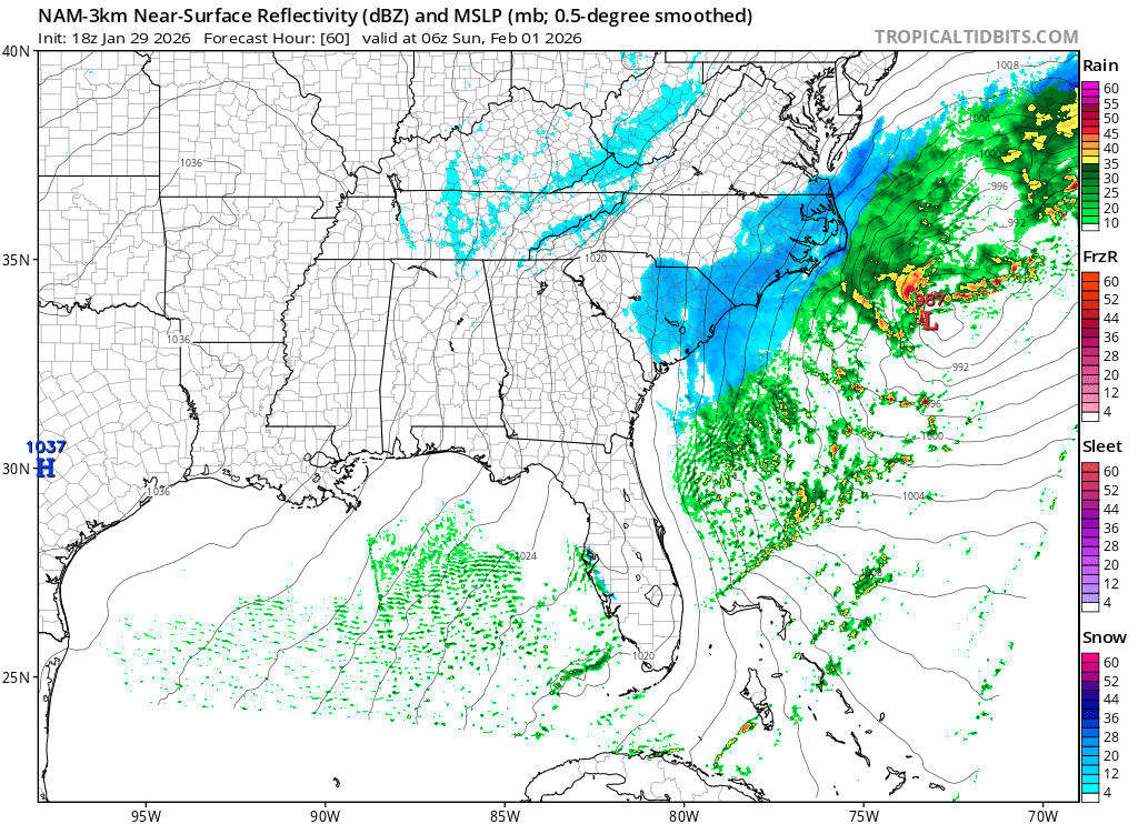
The question is, which one do you buy? The EURO has paid me way more times than the NAM ever thought about. Just say'n. -

Pittsburgh/Western PA WINTER ‘25/‘26
colonel717 replied to Burghblizz's topic in Upstate New York/Pennsylvania
Is it "Big Boss" only for east of here and coast? -

February 2026 Medium/ Long Range Discussion: Buckle Up!
WinstonSalemArlington replied to Weather Will's topic in Mid Atlantic
Woop Woop! -

The “I bring the mojo” Jan 30-Feb 1 potential winter storm
SnowDawg replied to lilj4425's topic in Southeastern States
I just can't confidently believe in the Euro totals in GA and upstate with the NAM/RRFS continuing to be so dry. -
Insane


-
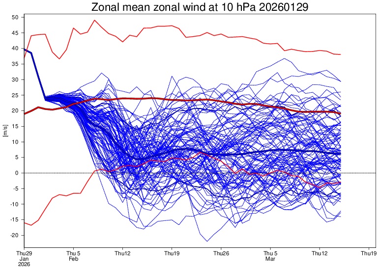
Blocking continues


-
The “I bring the mojo” Jan 30-Feb 1 potential winter storm
Aleksey replied to lilj4425's topic in Southeastern States
HRRR and NAM both give me 2”+ in NE GA and thats at 10:1. Ratios will be around 20:1 over here based off our latest NWS briefing that just got done. Any totals you fan multiply by 1.5-2 because ratios of 15:1 to 20:1. Sitting pretty over here [emoji3587] . -

The “I bring the mojo” Jan 30-Feb 1 potential winter storm
Ravens94 replied to lilj4425's topic in Southeastern States
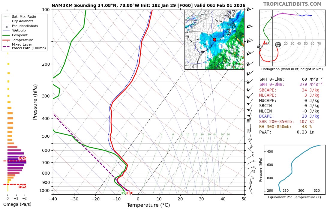
I mean this is rippage based on soundings.
-

The “I bring the mojo” Jan 30-Feb 1 potential winter storm
NorthHillsWx replied to lilj4425's topic in Southeastern States
It’s insane to me we’re talking about a storm with coastal influence and possible 20:1 ratios. To say that’s rare would be a massive understatement -

The “I bring the mojo” Jan 30-Feb 1 potential winter storm
AGardiner87 replied to lilj4425's topic in Southeastern States
https://www.facebook.com/share/p/1A3p99WK5K/?mibextid=wwXIfr Lastest from Brad P! -
I don't know. Normally, one doesn't see such a pattern. More may have been involved.
-

1/30-1/31 Lake Effect Snow Threat - SE WI, NE IL, and NW IN
Baum replied to A-L-E-K's topic in Lakes/Ohio Valley
Why not just WSW from noon to midnight in that county area for potential of 6” or greater? -
The “I bring the mojo” Jan 30-Feb 1 potential winter storm
HWY316wx replied to lilj4425's topic in Southeastern States
FFC out of Atlanta afternoon video is really good stuff! -

The “I bring the mojo” Jan 30-Feb 1 potential winter storm
NC_hailstorm replied to lilj4425's topic in Southeastern States
The long range HRRR has snow ratios at 17 to 20 to one,it's gonna stack up. -

The “I bring the mojo” Jan 30-Feb 1 potential winter storm
Regan replied to lilj4425's topic in Southeastern States
“More and more models” -
Jeez this is insane. People quickly thought February was going to torch because of La Nina but there were signs of it fading in December. This might end up the coldest winter in a long time for many areas.
-
The “I bring the mojo” Jan 30-Feb 1 potential winter storm
Berlin1926 replied to lilj4425's topic in Southeastern States
And south-central virginia -

Richmond Metro/Hampton Roads Area Discussion
jlewis1111 replied to RIC Airport's topic in Mid Atlantic
Yup def a beach storm kitty hawk up to you guys.. Congrats -
The “I bring the mojo” Jan 30-Feb 1 potential winter storm
Ravens94 replied to lilj4425's topic in Southeastern States
3k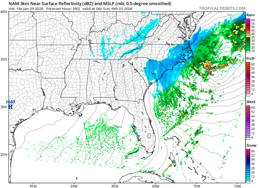
-
Ocean temperature gradient
-
The “I bring the mojo” Jan 30-Feb 1 potential winter storm
Ravens94 replied to lilj4425's topic in Southeastern States
I wouldn't use the nam for precip at all at this range. It's going to move every run -
We cant have the ULL track as far north as the NAM and RFFS show or we will get downsloped plain and simple. Luckily the Euro, GFS (somewhat) and AI models have it going in a better spot for us.