All Activity
- Past hour
-

Central PA Winter 25/26 Discussion and Obs
Jns2183 replied to MAG5035's topic in Upstate New York/Pennsylvania
I bit the bullet and downloaded state colleges record daily weather going back to 1894 and built a model to run 100,000 simulations. Got it to pass all over fitting tests, have a 99% percentile correlation, 94% interweek variability correlation, 98% intra- seasonal correlation based on auto-lag correlations. To have repeat of winter 1992-1993 and 1993-1994 back to back order not important it is a 1:1666 year event. To repeat the first four years of the 1960s 1:768 year event. Sent from my SM-S731U using Tapatalk -

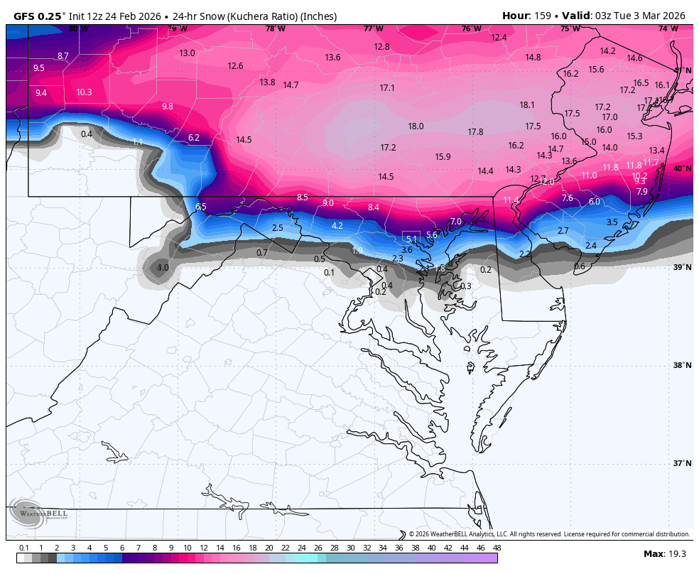
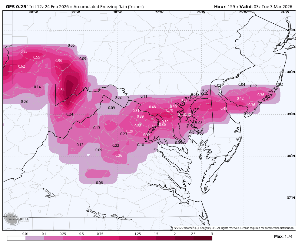
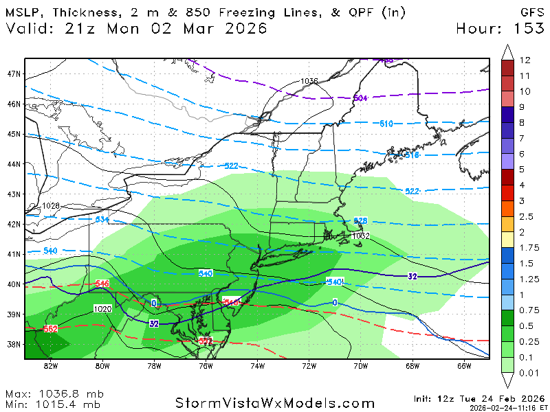
Late February/Early March 2026 Mid-Long Range
Weather Will replied to WxUSAF's topic in Mid Atlantic
It is close to being good for many of us. Someone should start a thread Th. If it is still there.

-
I'd say we can toss Thursday now just about though in winters like this I would caution don't dump it totally. Because this is the type of winter it'll find a way to make a comeback and we get a couple of inches.
-
Funny thing about depth and snowfall totals. Providence where they had 38 inches has a max depth yesterday of 21 inches.
-
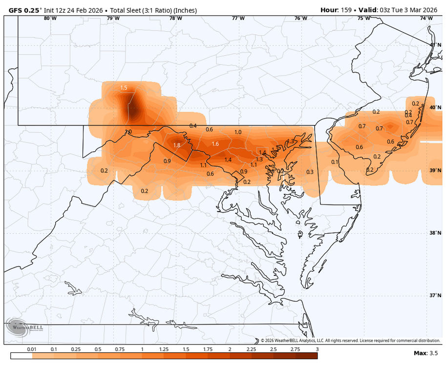
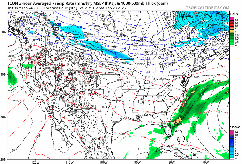
Nam and Icon try.. Icon bumped a good amount north at 12z
-
AIGFS probably all snow for metro areas Monday?
-
AI gfs is full-on Spring starting 3/5!
-
GFS way south with Monday Tuesday potential .. AI models not interested at all ... GFS with a northern mid atlantic special
-
Verbatim would be an impactful mixed precip event north of DC with temps in the 20s.
-

E PA/NJ/DE Winter 2025-26 Obs/Discussion
MJO812 replied to LVblizzard's topic in Philadelphia Region
Lets do it again
-
Bout 15” in Meriden
-
Gfs has 8-12 inches next week
-
Have you taken a look at what the AI GFS has been showing for the March 6th through the 10th, temperature wise? That might melt it all...
-
I get 34.5” measuring different areas in back yard. I’m 4 miles SSW from PVD. Incredible storm. For me, 1978 is still number 1. I was living in Providence then and while we may have had more snow, the ferocity of 1978 coupled with the societal impacts sets it apart. I was also in central NJ for 1996, that’s number 2 for me…

-

February 2026 OBS & Discussion
CentralNJSnowman replied to Stormlover74's topic in New York City Metro
12z GFS says we do it again next Monday -
Next week on the Gfs in mby is sufficient for me to forget 2 days ago and end the winter looking forward to next year's Niño.
-
Other than the town of Oxford (western Maine) which had only a trace, our 0.2" is the lowest amount reported to cocorahs, as of 11 this morning. (5-6 sites reported precip but left snowfall as NA. Other sites in those areas all had at least 1" snow and up to 5". Tops in Maine is 11.3" in Washington County.)
-

-

"Don’t do it" 2026 Blizzard obs, updates and pictures.
bristolri_wx replied to Ginx snewx's topic in New England
Haven’t left my street yet. No downed trees in my immediate neighborhood. -
GFS barely scrapes, AI models and GFS have been a bit more bullish especially AI models , I think ceiling with this is 1-3" south of pike . AIFS had several runs with 3-6" south of pike then last run was like coating to 2"
-
With the heaviest snow falling during daylight yesterday it was relatively low impact on main roads that were salted. Turned out to be a nice late season event. Can't believe such little snow fell at CLE though... the airport specifically always seems to miss .
-
10 years ago...
-

"Don’t do it" 2026 Blizzard obs, updates and pictures.
OceanStWx replied to Ginx snewx's topic in New England
Part of me kind of misses the days of broad ranges with highlighted zones for "locally higher amounts" The problem these days is that you can try and forecast the band from PVD-GHG on this run. But then the next run it's ORH-BOS, so you increase the snow there. But you don't want to drop it from PVD-GHG just in case that was actually right. So the snow amounts are forever only going up until it's too late to recover from the messenger shuffle. -

Clipper Fires In Wednesday Feb 25 Disco/ Obs
Sey-Mour Snow replied to Damage In Tolland's topic in New England
Euro is warmer in the afternoon. I’m not saying Hrrr is saying it’s not going to be cold enough to snow, it’s just really cold tonight and tomorrow AM then rises quickly to freezing.