All Activity
- Past hour
-
Yeah I’d put Friday's system as narrowly into Grinch territory. Usually they happen closer to Xmas but if it’s 6 days out that is prob close enough. At least we have a shot at redemption though. It would be nice to get 2 in a row after we weaseled a decent snow event before Xmas last year.
-

Central PA Winter 25/26 Discussion and Obs
Superstorm replied to MAG5035's topic in Upstate New York/Pennsylvania
Wonder if THV was ever national low? -

Winter 2025-26 Medium/Long Range Discussion
Geoboy645 replied to michsnowfreak's topic in Lakes/Ohio Valley
If this incoming ridge pattern was in June or July, it would be a ridge rider pattern with MCS's every night. Good thing it's *checks notes* the week of Christmas. -

Central PA Winter 25/26 Discussion and Obs
pasnownut replied to MAG5035's topic in Upstate New York/Pennsylvania
I obviously missed what happened, but no matter...happy that @paweatheris back. Wishin you all the best. -

December 2025 regional war/obs/disco thread
WxWatcher007 replied to Torch Tiger's topic in New England
Good thing that’s been our bread and butter for years now. I’d say it’s anything that rains or wipes the pack within 5-7 days of Christmas…but This 100%. If it rains but then we snow, the Grinch is either defeated or if it’s in the same storm (rain to snow) then it grew a heart. -
Central PA Winter 25/26 Discussion and Obs
pasnownut replied to MAG5035's topic in Upstate New York/Pennsylvania
I saw 4 on digi car thermo between Manheim and Etown. 10 at my house. skiff of snow all we had last night. Trainer sucked it all outta the clouds on the way east. -

Central PA Winter 25/26 Discussion and Obs
Mount Joy Snowman replied to MAG5035's topic in Upstate New York/Pennsylvania
THV hit -1. National low was only -8 at Presque Isle, ME. -
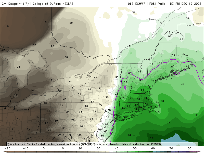
Open those windows Fri morning and let the dews in.
-
For records sake, the anomaly at Madison the first half of the month was -12.6 (!). We will see what it actually ends up being by the end of the month.

-
What will be higher? Your max temp or gust?
-
I used the top of my deck table which was in a good spot. Easy to measure like you said.
-

December 2025 regional war/obs/disco thread
Damage In Tolland replied to Torch Tiger's topic in New England
https://twitter.com/bostonwxconsult/status/2000911081170956622?s=46&t=dhcbvkjmRcyBVQtDxJ3lRg -
I got 9+ on the grass too. The 3 boards were all the same at 7.6. it's cool how consistent they were with no wind...easy measurement. There's no consistency on the lawn.
-

December 2025 regional war/obs/disco thread
weatherwiz replied to Torch Tiger's topic in New England
the NAM hints at that potential but it has a little pocket of steeper lapse rates and some higher MUCAPE. The NAM I think can often overdo those in these setups but its not unheard of to get some thunder/lightning with these, especially towards the outer Cape/Islands. -
One that does not populate the weather map. A subtle over-running of warm air on the northwest flank of departing high pressure.
-
Looks like Xmas torch is back on the menu.
-

December 2025 regional war/obs/disco thread
HoarfrostHubb replied to Torch Tiger's topic in New England
I would not be shocked at some thunder reports -

Central PA Winter 25/26 Discussion and Obs
paweather replied to MAG5035's topic in Upstate New York/Pennsylvania
Thanks Training -
December 2025 regional war/obs/disco thread
weatherwiz replied to Torch Tiger's topic in New England
I'm also curious as to exactly how high temperatures will climb in the warm sector Friday. You'll have a southerly flow coming off unseasonably cool waters, plus coming off a snow cover on Long Island Sound and then across southern CT. I wonder if it will be more upper 40's versus lower 50's type stuff (not that I guess it matters much). Wind potential probably held back too because I'm sure there would certainly be a stout inversion. Maybe some wind potential if any elevated convection can be generated. -
Ray, If you mean the link to the site that produces the graphs of 10 hPa/60N mean zonal wind back to 1978-9, those could be produced by going in here: https://acd-ext.gsfc.nasa.gov/Data_services/met/ann_data.html#ncep_clim_stats_nh
-

Central PA Winter 25/26 Discussion and Obs
Itstrainingtime replied to MAG5035's topic in Upstate New York/Pennsylvania
Interesting snippet from CTP's forecast discussion this morning: ( @canderson) The biggest story on Friday will be the potential for strong to damaging wind gusts. Building high pressure in the southeast US will interact with the potent and deepening cyclone crossing the Great Lakes to produce wind gusts exceeding 40mph Friday afternoon in the wake of the cold front. Anomalously strong wind fields could result in fairly widespread gusts of 40-50mph across the northeast US Friday afternoon. Wind Advisories may be needed for at least a portion of the area. -

December 2025 regional war/obs/disco thread
WinterWolf replied to Torch Tiger's topic in New England
Agreed…and we’ve had a lot of very nice/great patterns of late, that produce zero…or very little. I’ll take my chances with the not so pretty, or mediocre at best pattern and give that a shot. -

December 2025 regional war/obs/disco thread
Ginx snewx replied to Torch Tiger's topic in New England
Take a good look at surface temps from Friday on. High barometer and low barometer cold. -

Winter 2025-26 Medium/Long Range Discussion
DocATL replied to michsnowfreak's topic in Lakes/Ohio Valley
Excited for the thaw though and no more dirty ice sheets! -
I don't care what anybody says. That is impressive and was well advertised. We'll see where the month actually ends.


