All Activity
- Past hour
-
Will see the developing cu pass overhead here early afternoon. I'll crack open a beer and raise a toast to them and wish them well on their eastward journey.
-
This is the first evening that's really felt like warm season. 8:30pm and 68F... all windows and three sliding doors wide open. Still some light outside. What a couple of days and this evening has the feels, listening to the peepers and insects, late light, smell of fresh cut grass. Warm season. Still near 80F up in N.ME.
-
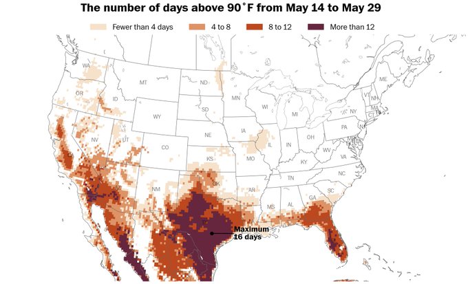
Showers will wind down later tonight. Although parts of the region picked up 1.00" or more of rain over the past two days, much higher amounts of rainfall were recorded farther south. For example, parts of western Virginia and western North Carolina saw more than 3.50" of rain. Sedalia (4 NW), VA picked up 5.36" of rain. It will turn somewhat warmer tomorrow and the week could end with temperatures in the upper 70s to perhaps 80°. Showers are possible during the weekend. Elsewhere, parts of Texas are experiencing extreme heat. Cotulla, TX reached 112°, which broke the May monthly record of 110° that was set just yesterday. Meanwhile, International Falls reached 91°, its fourth consecutive 90° day. The prior earliest four-day heatwave occurred on June 4-7, 1988 The extended guidance has grown noticeably cooler for the second half of May than it had been. Both the CFSv2 and ECMWF weekly guidance are now in good agreement that the second half of the month could average near or even below normal overall. Consistent with the guidance, it could turn unseasonably cool early next week following the coming weekend. The ENSO Region 1+2 anomaly was 0.0°C and the Region 3.4 anomaly was +0.1°C for the week centered around May 7. For the past six weeks, the ENSO Region 1+2 anomaly has averaged +0.55°C and the ENSO Region 3.4 anomaly has averaged -0.07°C. Neutral ENSO conditions will likely continue through at least mid summer. Early indications are that summer 2025 will be warmer than normal in the New York City and Philadelphia areas. The potential exists for a much warmer than normal summer (more than 1° above normal). The SOI was -3.35 today. The preliminary Arctic Oscillation (AO) was +0.160 today. Based on sensitivity analysis applied to the latest guidance, there is an implied near 66% probability that New York City will have a warmer than normal May (1991-2020 normal). May will likely finish with a mean temperature near 65.0° (1.8° above normal).
-
3K NAM, RRFS suggest the Sycamore area could well be in the bulls-eye.
-
Think I’m sitting a bit too far west unless things slow down, but looking forward to watching Gary, IN get tossed into the lake.
-
A month away? Cmon man. Haven't we learned anything about long range winter busts Sent from my SM-S921U using Tapatalk
-
It's been well above average but not alot of heat. I did turn my ac on last weekend when it was upper 80s
-
.83", up to 5.66" for the month.
-

2025-2026 ENSO
Stormchaserchuck1 replied to 40/70 Benchmark's topic in Weather Forecasting and Discussion
Here's what I'm looking at Ray -
Some super long-range looks show no real heat until early June to mid June. I like it !
-
How the heck is it May 14th and we still haven't put in the window AC units? I don't ever remember it staying this cool this late in the year. Am I crazy?
-
Looks like the NAM twins and the RRFS (spelling?). Not necessarily buying their output, especially beyond 48 hours, but they're definitely trying to cause some problems.
- 508 replies
-
- 1
-

-
- severe
- thunderstorms
- (and 2 more)
- Today
-
Which ones?
- Yesterday
-
I have not looked at this in great detail, but did a quick and dirty look and here are my thoughts regarding Friday night: For West TN and East AR, timing maybe the downfall to this event as the cold front appears to lagged behind, especially back towards the southwest. Model guidance shows any storm development will not only be along the frontal boundary but also occurring after 00z. While that is not terrible given the time of year, would still like to see some sort of prefrontal development before 00z. Secondly, there appears to be little to no prefrontal convection. This indicates there is a lack of forcing within the vicinity or the cap could be too strong for storms to overcome. For MO into KY, model guidance shows what looks to be a MCS to develop across the region. This is likely where the severe weather threat will be the greatest and would contain both the greatest wind and hail threat for Friday evening. Again, timing scares me off as a chaser given it will be near that 00z time frame. However, the MCS could provide a boundary downstream into Northeast AR and potentially Northwest TN that could allow for an isolated discrete cell or two to developed.
-
Sickening.
-

E PA/NJ/DE Spring 2025 Obs/Discussion
Hurricane Agnes replied to PhiEaglesfan712's topic in Philadelphia Region
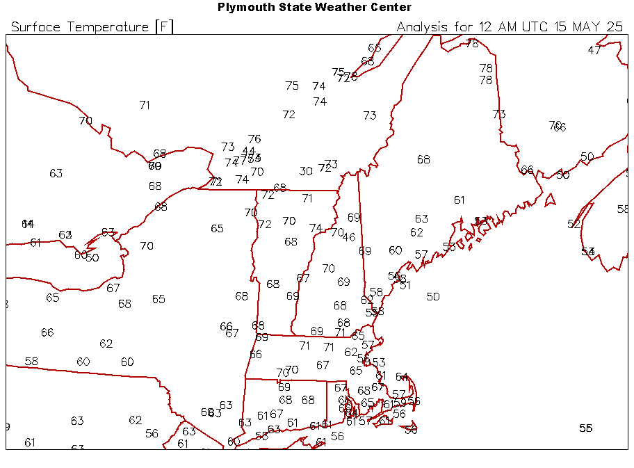
So far with today's round, I ended up with 1.64" at post time for a 2-day event total of 2.21" of much needed rain! It's currently overcast and misty and am at my high for today of 64, after a low of 58, and with dp 64. -
2025-2026 ENSO
Stormchaserchuck1 replied to 40/70 Benchmark's topic in Weather Forecasting and Discussion
The decadal NAO may be more realistically 20 years from changing its state. Early 1900s - positive, 60s and 70s - negative, peak positive lately? -
This is ridiculous for June 11th 3C at 850 mb
.png.7736d5ba95ca290ab3d69da3a213d60a.png)
-
not trying to troll but actually kind of shocked... 12z CFS long range keeps this pattern going through mid June..
.png.0eb77b568a5f29a66816a4e145a63930.png)
-
Yeah. I know exactly which CAM prompted that reaction from you... just have the MCS track 60-75 miles further north and...........
-

2025-2026 ENSO
40/70 Benchmark replied to 40/70 Benchmark's topic in Weather Forecasting and Discussion
Exactly. ..that is what I honed in on. -
2025-2026 ENSO
40/70 Benchmark replied to 40/70 Benchmark's topic in Weather Forecasting and Discussion
Out winter seasons are like the Celtics now....all or nothing...either the 3s hit, or they don't and they stumble. -
Heading to Lake Harmony tomorrow-Sunday. Was hoping I’d be far enough north to get out from the clouds but alas, looks unsettled up there too the entire trip. Blahhh
-
trust me none of that gets in once I do it I'll take a pic of it for you to ease your concerns
-
Some of the CAMs at range for Friday


.thumb.jpg.049f4a7f726ada07e8cd30bd17e713cb.jpg)


