All Activity
- Past hour
-

Central PA Winter 25/26 Discussion and Obs
Superstorm replied to MAG5035's topic in Upstate New York/Pennsylvania
Not liking this cold and snow in Europe. Tends to get stuck over there for a while. . -

January 2026 regional war/obs/disco thread
jbenedet replied to Baroclinic Zone's topic in New England
It’s not good— period —that the first pattern shake up of met winter is to land on hostile warmth for our region. If we didn’t land here at all it would portend better snow odds. Now we arrived here and need to hope for another shakeup. It’s just a game of odds…The long wave features are landing unfavorably. It also looks increasingly likely that it will stick beyond mid month. That said, the hostile period beginning around the 6th also is very unlikely to stick indefinitely. What’s most likely to me is we will settle in a gradient pattern. This has performed well in recent years from a line from just north of PWM, through DAW to N ORH. And extremely well in the far interior of NNE. Points south/east of there have been approx 50% of normal. That’s basically my expectation starting after the 15th. If this doesn’t work well for your lat/long or expectations, hope for another reshuffling in February. Still plenty of time for more shakeups…. -
Some good lake effect video on this guy's X feed. https://x.com/ChasingWConnor
-
12/5 0.2” 12/13 2.8” 1/1 0.1” Total: 3.1”
-
I’m about ready to call it. Nothing promising and if I hear the mountain crew say “it can snow in February and March” I might just go bananas. Guess a chilly Thanksgiving and first half of December with a Record warm Christmas week will be the story.
-

January 2026 regional war/obs/disco thread
weatherwiz replied to Baroclinic Zone's topic in New England
Yeah you've been pretty spot on so far. It can be really difficult to forecast the extent of the more anomalous regimes teleconnections can become. -
BAM weather is shutting the door on a potential flip to colder weather starting the 12th. They’re not ruling it out completely but they’re saying the polar vortex might not drop through North America, cutting off the cold air source. Remember, it’s been quite cold across northeast and Midwest, but rest of CONUS has been quite warm. Doesn’t look to have any end in sight. Winter never arrived for many places and without some cold air over there, there won’t be snow. It’s always good to see ample cold air and snow to our west. Instead; it’s only been directed towards our region since early December. Would be better for our storm chances if this changes up
-
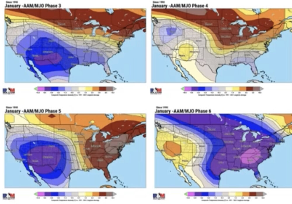
Today’s EPS and CFS are also going to ph 6 mid Jan. BAMwx posted that phase 6 in -AAM during Jan has been very cold in the E US, with the most intense cold in the interior SE (see lower right in image just below), which to me was very counterintuitive. So, I needed to know the answer. Now it’s even more important to know as the move to ph 6 midmonth now has increasing model support. The following are results of my research done on Tue, which looked at GSP, a station in that coldest (pink) area, during La Niña: Niña Year….# phase 6 days…avg anomaly 1975…3…-8 M 1976…13…-9 W-S 1989…3…+8 M 1999…3…+2 M 2000…3…-4 W 2006…6…+3 S 2008…3…+8 S 2009…6…+1 W-M 2011…12…-7 W-S 2012…19…+1 W-S 2017…2…0 W 2018…3…-2 S 2021…8…-1 M-S 2022…4…-9 W 2025…2…-5 W W weak (mainly in or near circle), M mod., S strong 91 total days (big sample) ————— So, 15 cases of ph 6 during Nina Jans: 3 MBN 3 BN 6 NN 1 AN 2 MAN ——————— - These La Nina Jan results weren’t at all what I would have expected for phase 6, one of the 3 mild Jan phases in the SE averaged out over all years: - Though there’s not surprisingly lots of variability, GSP did average 2 BN. Before seeing BAMwx’s post I never would have expected this. However, it should also be noted that BAM’s -6 to -7 for GSP is at the same time significantly too cold. - Only 3 of the 15 Jan cases were AN to MAN: 1989, 2006, and 2008. These were all M to S intensity (intuitive). - So, none of the last 8 were mild as there were 5 NN and 3 BN (2011, 2022, and 2025). These also averaged 2 BN. The weakest 3 averaged a solid cold 6 BN. - Thus if phase 6 continues to look more likely for midmonth, it will be interesting to see whether or not the NN to cold dominance works out in the SE (and E overall by association), especially if the bulk of ph 6 turns out to be anywhere from inside the circle to near/just outside the circle.
-
Looking at the CFSv2 LR model this morning, it does indeed keep retrograding the 500 ridge into Asia. It retrogrades the eastern trough into the Mountain West....and then it retrogrades yet another ridge into the West and holds it. If that happens, Larry Cosgrove is going to score the coup, and kudos to him for a great seasonal forecast if it does. He has adamantly held that the end of January and early February will hold the worst of winter, and cautioned patience. I think the ridge getting knocked down out west, reforming....wash, rinse, repeat...is the likely pattern beginning on the 12th. One could make a pretty good case that began on Dec 29th. I think at least one of those cycles will have very cold air in the pattern. A lot of decent winters featured that pattern. Let's see if that is how it unfolds. Either way, this winter has been one of wild swings...I fully expect that to continue.
-

January 2026 regional war/obs/disco thread
40/70 Benchmark replied to Baroclinic Zone's topic in New England
This is why you incorporate the QBO and solar cycle into analogs. I think my progression has been good so far....only blemish is the severe -WPO making December colder than I thought....but moving forward, I was confident in latter January +TNH last fall, and still am now. -
(002).thumb.png.6e3d9d46bca5fe41aab7a74871dd8af8.png)
Central PA Winter 25/26 Discussion and Obs
ChescoWx replied to MAG5035's topic in Upstate New York/Pennsylvania
As I had mentioned yesterday some models were hinting at some snow showers overnight and we did indeed see some overnight which as many have mentioned recoated drives across the area. Here in East Nantmeal we picked up 0.3" of snow. We continue with well below normal temperatures through Monday but then see a nice warmup with temperatures trending well above normal for much of next week. Overall the next week or so looks dry with maybe a snow shower chance Saturday night.
-
E PA/NJ/DE Winter 2025-26 Obs/Discussion
ChescoWx replied to LVblizzard's topic in Philadelphia Region
As I had mentioned yesterday some models were hinting at some snow showers overnight and we did indeed see some overnight which as many have mentioned recoated drives across the area. Here in East Nantmeal we picked up 0.3" of snow (our 8th winter event of the season). We continue with well below normal temperatures through Monday but then see a nice warmup with temperatures trending well above normal for much of next week. Overall the next week or so looks dry with maybe a snow shower chance Saturday night.
-
January 2026 regional war/obs/disco thread
40/70 Benchmark replied to Baroclinic Zone's topic in New England
I'm pretty confident that any huge PV infiltration would knife down through the center of the country, anyway. -
https://x.com/bam_weather/status/2007075997565284655?s=46&t=NyKvXvI1o-sJQb-68mmo4g This is the tweet. I think we’re seeing all the signs that winter might not return in January. I wish I could be optimistic but nothing looks good on modeling and all the long range indicators are starting to throw red flags. I think a lot of Mets jumped the gun before Christmas
-
January 2026 regional war/obs/disco thread
40/70 Benchmark replied to Baroclinic Zone's topic in New England
Last season I bailed after that big January threat failed. We has one decent stretch in early Feb and that was it. I felt like March was a lost cause dating back to the fall, and I was absolutely correct. It was. -
That overnight snowfall played out similarly here at our site – the underlying snowpack is currently consolidated enough that we picked up 4 inches of snow, and the snowpack depth went up the same amount. We’ve had a lot of continuously settling snowpack over the past couple of months with the types of systems we’ve been seeing, so each round of new snow has typically been compressing the underlying snow. This snow from this recent clipper was fairly dry down here (4 to 6% H2O), so it’s already settled an inch since yesterday.
-
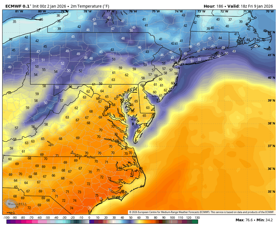
WB 0Z EURO. Looks like the mini thaw peaks on January 9. Hopefully, we will have something to track by next weekend for the second half of January. (By the way, this is very consistent with what the extended EURO has shown for several weeks. No can kicks here....).
-
January 2026 regional war/obs/disco thread
40/70 Benchmark replied to Baroclinic Zone's topic in New England
I don't know, ask someone who think it's over- -
January 2026 regional war/obs/disco thread
40/70 Benchmark replied to Baroclinic Zone's topic in New England
I think "by January 12th" is aggressive, anyway. -

January 2026 regional war/obs/disco thread
UnitedWx replied to Baroclinic Zone's topic in New England
I get that some are irritated, but we need to roll with it like always. We have NO idea what is really going to happen and that's part of the fun. Look at what models showed a few days back huge blocking etc. They recalculated like a crappy Garmin GPS and will again. Into what... stay tuned LOL. Wasn't it somewhere around 2015 where we didn't have any sign of winter until near mid January and then we were off to the races -

Winter 2025-26 Medium/Long Range Discussion
DocATL replied to michsnowfreak's topic in Lakes/Ohio Valley
Never a harbinger, always a curse. -

January 2026 regional war/obs/disco thread
WinterWolf replied to Baroclinic Zone's topic in New England
For sure. Very wintry out there now, and has been for the holiday season too. Looks, feels and seems like it should for late December, and now for the very start of January in a lot of places. -
Oh boy. Now we’re starting to see Bam have cold feet.
-

Winter 2025-26 Medium/Long Range Discussion
Cary67 replied to michsnowfreak's topic in Lakes/Ohio Valley
Sub 30" seasonal totals will be tough with 2.5 months worth of nickle dimer chances left. Already at 20" here for the season. Another week or 2 window of opportunity will probably reveal itself before mid March. However N.IL was pretty much ground zero for the 1st window; doubt it happens for the 2nd window. -
Im not sure all areas will go green during that period but I'm curious why you view that as better?


