All Activity
- Past hour
-
Forget it if this is right


-
Just in time for April

-
*shudder* That was the year after I opened a ski/snowboard shop. Both of my first two years sucked for snow.
-
Timber just in time for April


-
Snark with nothing useful, thanks
-
Nah, temps will bust low. Don’t think most of us crack 50 east of the city
-
Warm Today ?
-
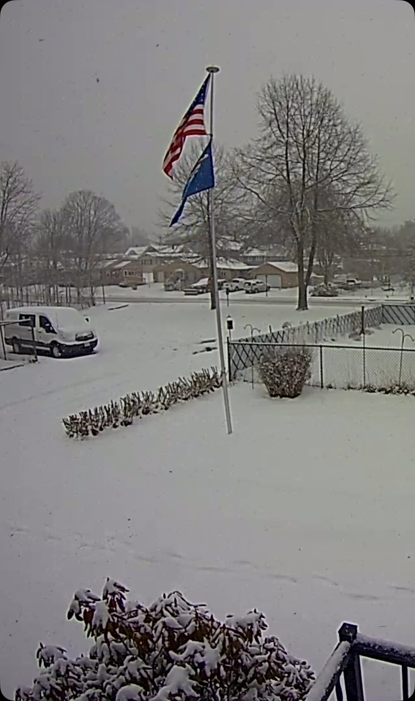
SN, 29/28°F, 2" so far. SPECI KLEW 221551Z AUTO 09007KT 1/2SM SN FG SCT006 OVC010 00/M02 A2990 RMK AO2 PRESFR P0000 FZRANO

-
Try again in 82 years
-
Snowed for a bit earlier but driveway has cleared itself already. Dropped from 35 to 34.
-
you're enjoying it too much..act like it hurts
-
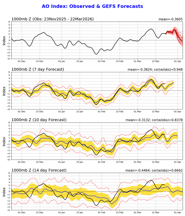
If the new EPS is correct, it’s going to get very warm again the 1st week of April
-

2026-2027 El Nino
snowman19 replied to Stormchaserchuck1's topic in Weather Forecasting and Discussion
EPS is projecting a TC or possibly a pair/twin TC’s to develop within the big WWB. What happens with those could be very important in terms of how strong this El Niño gets down the road….. -
Eyeballing about 2” in Glen, NH.
- Today
-
very chilly this morning i was out in my full winter gear
-

Central PA Spring 2026 Discussion/Obs Thread
Voyager replied to Voyager's topic in Upstate New York/Pennsylvania
I just came along to mention the same exact thing. Seems to me that this one may produce better than Monday did. -
 The dude was an international superstar!
 -
Bring it. Screens in the door, warmer temps. I'm ready for it. Plus it'll help with my partner healing from her knee replacement surgery.
-
Decent rates. All sn, anout 0.5". 29f Sent from my SM-S921U using Tapatalk
-
Rain showers moved through last night. Snowpack dwindling quickly. Although highs today will be around freezing so not so much today.
-

E PA/NJ/DE Spring 2026 Obs/Discussion
Albedoman replied to PhiEaglesfan712's topic in Philadelphia Region
Mike, I expect a tornado watch or severe thunderstorm watches to be issued by 3pm in our area. Unlike last weeks storm event, the sun will be coming out in the next few hours based on the satellites imagery. The chances of severe weather will double when this happens with the unstabilized air mass in place. I would expect many severe t- storm warnings this evening becuase of it. Its already sunny near Harrisburg. Not a good sign. This forum will be lighting up later this evening with the severe weather reports. I see Hagerstown MD has a high in the low 80's. Just prime for tornado formation too. -
It’s wild that 2 months ago we were tracking a snowcrete storm and an anomalous stretch of cold that left mounds of snow and local lakes frozen to the point that you could play ice hockey on them. That was fun and interesting meteorologically, but needless to say I prefer this weather. Screen door is open, birds are chirping, and March Madness is ramping up.
-

Central PA Spring 2026 Discussion/Obs Thread
mahantango#1 replied to Voyager's topic in Upstate New York/Pennsylvania
Sun has been out now for a half hour. We'll see if it helps destabilize the atmosphere. -
March 22 1991: A historic ice storm begins during the afternoon and ends as heavy, wet snow on the 23rd. This event coated the city of Duluth with as much as 6 inches of ice. The 850-foot WDIO TV tower was toppled. 4 million pine trees were damaged or destroyed with the heaviest damage at G.C. Andrews State Forest near Moose Lake in Pine County. NOTE: That makes 2 historic events in my area in 1991 with the other being the "Halloween Blizzard", but I was still in the Army when this happened. 1952: A snowstorm dumps 13.2 inches on the Twin Cities. For Sunday, March 22, 2026 1920 - A spectacular display of the Northern Lights was visible as far south as Bradenton FL, El Paso TX, and Fresno CA. At Detroit MI, the display was described so brilliant as to blot out all stars below first magnitude. (22nd-23rd) (The Weather Channel) 1936 - A great flood crested on rivers from Ohio to Maine. The flood claimed 107 lives and caused 270 million dollars property damage. (David Ludlum) 1954 - Six to ten inch rains caused the Chicago River to overflow its banks. (The Weather Channel) 1987 - An intense storm produced heavy snow in the southern and central Rockies, and high winds from southern California to West Texas. Wolf Creek Pass CO received 24 inches of snow, and winds gusted to 69 mph at Ruidoso NM. Blizzard conditions were reported in eastern Colorado. (The National Weather Summary) (Storm Data) 1988 - Rain and high winds battered the Northern Pacific Coast Region, with wind gusts to 78 mph at Ocean Shores WA. The high winds uprooted trees and down power lines. Ten cities in the northeastern U.S. reported new record low temperatures for the date. Eight cities in the central U.S. reported record highs. Southerly winds gusting to 60 mph helped push the mercury at Ottumwa IA to a record warm reading of 83 degrees. (Storm Data) (The National Weather Summary) 1989 - Six cities in the Great Lakes Region, and three in southern Texas, reported new record low temperatures for the date, including Alpena MI with a reading of 9 above zero, and Brownsville TX with a reading of 38 degrees. (The National Weather Summary) 1990 - A surge of arctic air kept temperatures in the teens and 20s during the day in the north central U.S., and heavy snow fell over parts of Montana. Record warmth was reported in the western U.S.,and in Alaska. Phoenix AZ reported a record high of 94 degrees, and the town of Barrow, located along the arctic coast of Alaska, reported a record high of 20 degrees. (The National Weather Summary)
-
Yup…all pure snow now here too. Probably 3/4sm -SN


.thumb.png.4150b06c63a21f61052e47a612bf1818.png)


