All Activity
- Past hour
-
 Snow picked up the last hour with radar looking increasingly better
 -
The good news with this type of setup is there should be a fairly quick resolution to whether this will work around parts of Tennessee or not. I believe if it's not going to work it will move toward a mostly coastal or central Carolina snow over the next 24-36 hours of runs.
-
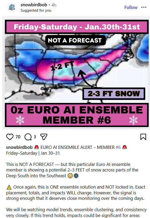
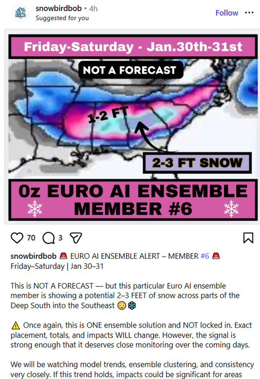
it would be almost funny if these slop weather pages didn't get ad revenue and clicks for posting ridiculous nonsense like this (and make everyone else think the weather is basically not predictable at all) ...
-
I think it's technically NoVA for the most part...I mean Bob abandoned us all to the southern corner of VA but other than that...yeah NOVA.
-
The ICON was almost another way to win a good storm, the case of a N/S digging and closing off passing where we'd like it to give us good snow. Just a few hours too late on the formation and tilting of the trough.
-
Which is exactly what I think our area should be rooting for (the coastal seems a reach). I’d like to see the energy out west a little further north and the ns system as well.
-
LWX AFD added a mention of the potential storm. KEY MESSAGE 3...The next round of winter weather is possible this weekend. A large scale, northern stream trough will dig south from the upper Great Lakes toward the central Appalachians this weekend. At the same time, a southern stream ejects from the Four Corners toward the Gulf states. As these systems phase along the Eastern Seaboard, there is good agreement that an area of low pressure develops along or near the coast. The location of the phasing will determine how close to the coast the low is. The long range models are painting a typical Miller A type Nor`easter that could bring wintry precipitation along some of the Mid-Atlantic coast. Cold air won't be an issue with an Arctic airmass leading up to the weekend (highs in the teens to low 20s Fri/Sat) and a reinforcing high building over southern Quebec/Ontario on Sunday. It is important to note that model uncertainty for any given solution is very high at 5-6 days out, but the ensemble guidance does hint at the possibility of some snow in the area this weekend. The 12Z European, GFS, and Canadian all have around a 20-30pct chance for 3" of snow east of the Blue Ridge. The NBM speak best to the wide range of possibilities for this system, with the 13Z run having a 20-30pct chance for 6" of snow, around 20pct chance for 12", around 15pct chance for 18", and around 5pct chance for 24". Expect model guidance to bounce around significantly over the next few days before settling on a solution by the end of this week. By Wednesday the regional models will have some output that goes into the weekend. For now, take note of this potential threat and continue to monitor for updates as the week progresses.
-

The “I bring the mojo” Jan 30-Feb 1 potential winter storm
olafminesaw replied to lilj4425's topic in Southeastern States
Nice, gotta focus on the big picture pieces. All the pieces are on the board,just need to nail down phasing/timing of all the energy. Will be a few more days of model mayhem before we can start focusing on the details -
 Makes sense thank you
 -

Snow Contest January 25th-26th
WeatherGeek2025 replied to WeatherGeek2025's topic in New York City Metro
we gotta find out the totals @donsutherland1 @dendriteyou know the totals for these cities you guys are major contributors here -
No it’s not
-
 Steady backbuilding bands and moderate, accumulating snow continues
 -
Who won?
-

January 25-26th, 2026 Final Storm Totals
The 4 Seasons replied to The 4 Seasons's topic in New England
yea once i heard the sleet mixing in so early, i think it was around 4PM, i was like oh boy here we go a changeover happening shortly and im gonna be stuck at like 10. but then it washed out and we snowed for several more hours with occasional sleet and rimmed flakes mixing and out. And we never fully changed over until about the end around 9PM when it was getting very close to the end. I dont think ive seen that happen before where the sleet line didnt just blow through with a clean changeover and we washed out like that. -
Yea that wasn’t going to escape .
-
Is Norfolk in our "CWA"? How far south do we go?
-
I see some leeside enhancement showing up which makes me hopeful. It all depends on how far south the ULL digs.
-

The “I bring the mojo” Jan 30-Feb 1 potential winter storm
HKY_WX replied to lilj4425's topic in Southeastern States
ICON EPS . Love the location of the HP. Generally a very good spot for SECS Miller A's. -

The “I bring the mojo” Jan 30-Feb 1 potential winter storm
Brick Tamland replied to lilj4425's topic in Southeastern States
18z only goes out 120 hours. -
Sharp, backed up PNA = winner Flatter, more east PNA = congrats Norfolk
-

The “I bring the mojo” Jan 30-Feb 1 potential winter storm
BornAgain13 replied to lilj4425's topic in Southeastern States
18z ICON looks good! Hopefully GFS keeps coming back this way -

January 2026 Medium/Long Range Discussion
SomeguyfromTakomaPark replied to snowfan's topic in Mid Atlantic
ICON is 100 miles to the right of going boom for us. Shift the trough that much and we’re good. -
Every model so far is giving Norfolk a low 970mbs Blizzard. Need to bring this storm closer to the coast for us. ICON is close but not quite there
-
It absolutely looks like 11-12” fell here and then some. The mall piles will be huge. Sleet is a buzzkill when it’s happening but we’re thankful tomorrow and after. It’s just hell trying to shovel it, but excellent for building and keeping snowpack.
-

Possible coastal storm centered on Feb 1 2026.
Baroclinic Zone replied to Typhoon Tip's topic in New England
18z ICON shifted entire ULL north NNE about 200mi. Looks like following 120hr it would ride up coast before kicking out to sea.